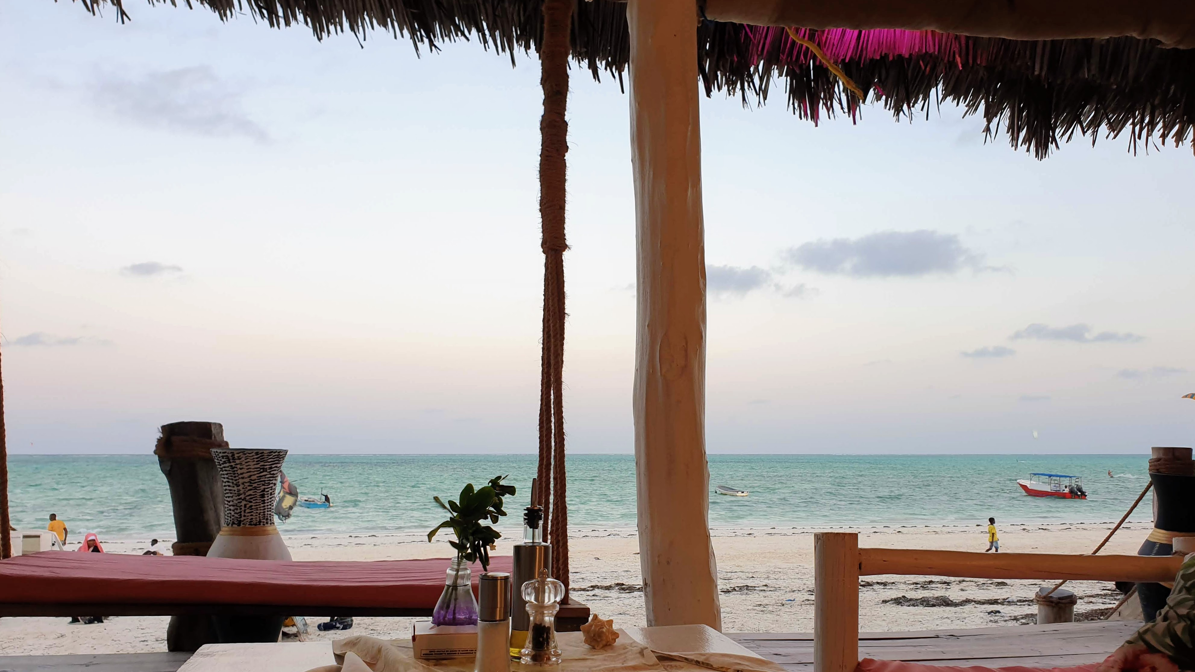
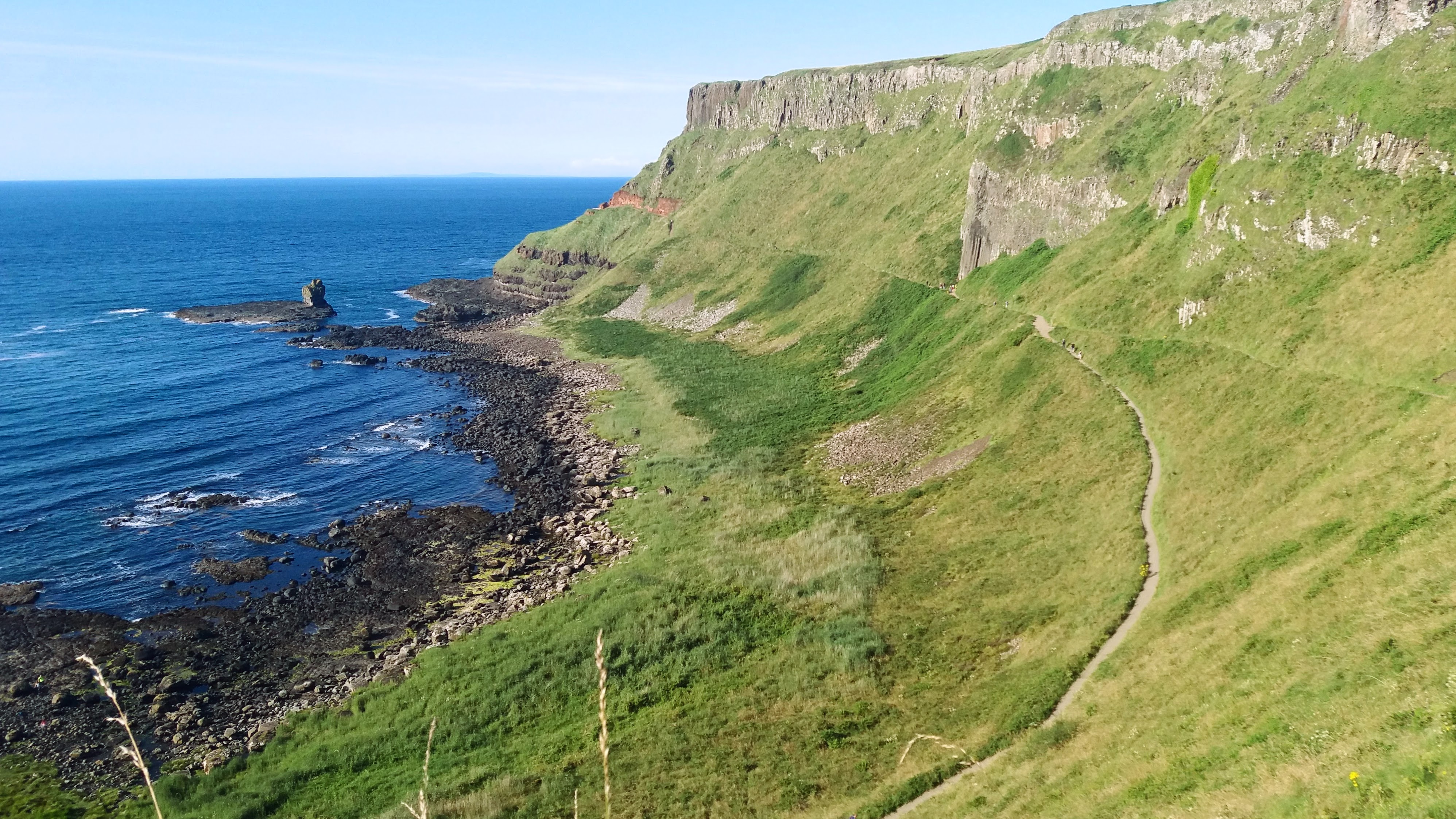
I spent a full week in Stone Town which might have been too much. It is where almost every tour leaves from, but after day 5 I was starting to feel like I had hit all the highlights. I missed out on Prison Island (where the giant turtles live) because the weather wasn’t good for the boat trip on the day I’d booked and I was too tired to navigate booking another day. Nevertheless, I was ready to move on. My second stop was at Paje Beach on the east coast of the island.
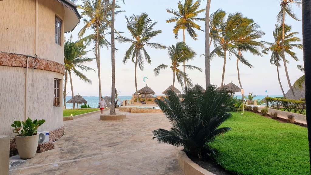
Paje is described as being more low key, less resorts and more backpacking beach bums. I booked a private room in a hostel that was less than 500m from the beach. The hostel itself was very cute with a courtyard filled with greenery and comfortable places to lounge. The art in the room was really strange, but the room was clean and sometimes that’s enough. There’s a single main road that goes through the town that’s lined with a mix of shops that serve locals and tourists. The roundabout has the town’s 3 ATMs only, one of which was working when I went. I met another traveler who said all three were out of cash the day before, so they had to taxi back to Stone Town just to get money since no one outside the resorts takes cards in Zanzibar (my hostel was cash only, too).


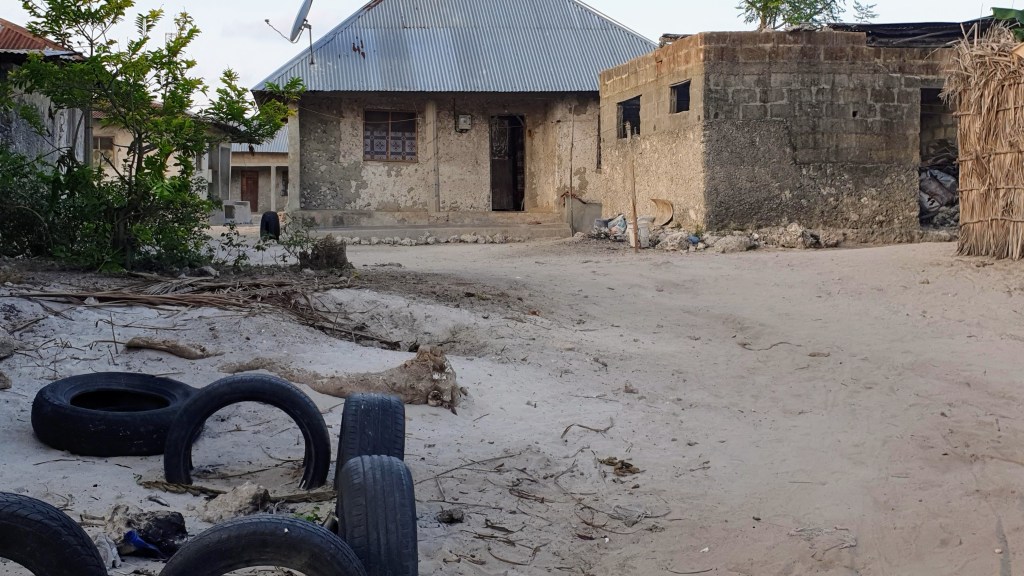
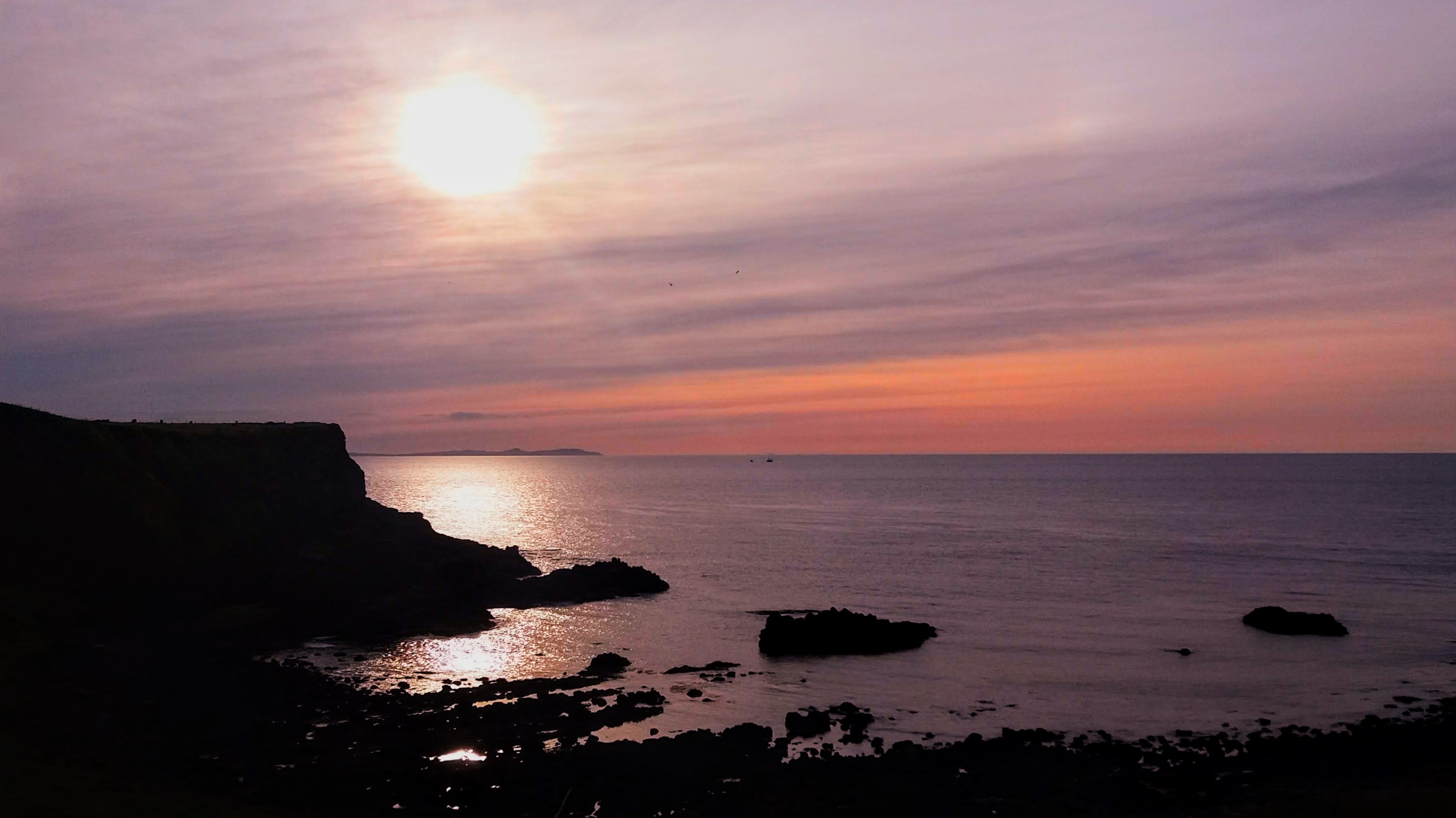
The town layout of Paje is very open compared to Stone Town and is consequently hotter. The afternoon I arrived, I had to hide inside until it cooled off because the walk to the ATM and back almost baked me. As dusk brought cooler air, I headed down to the beach for dinner and was surprised that the short walk was through a local neighborhood (the part not for tourists). It was heart wrenching to see the contrast of how the people who live in this paradise island live so close to the luxury beachfront resorts. Unlike some resort towns, at least the beach at Paje is open to all, and I saw plenty of local kids playing and a mix of abaya clad ladies amid the western beachwear.


At the restaurant, I accidentally brushed my leg against the leg of the chair and opened a few dozen micro-blisters that I didn’t even know I had. I knew that the burn I got on the back of my calves while snorkeling was not great, but I had spent several days keeping that area carefully out of the sun and applying aloe and shea lotion many many times each day (and night). I thought it was getting better and didn’t realize that there was a layer of blister basically on the whole thing. The casual bump against the chair leg started a cascade event where my skin decided it was time to peeeeeel.
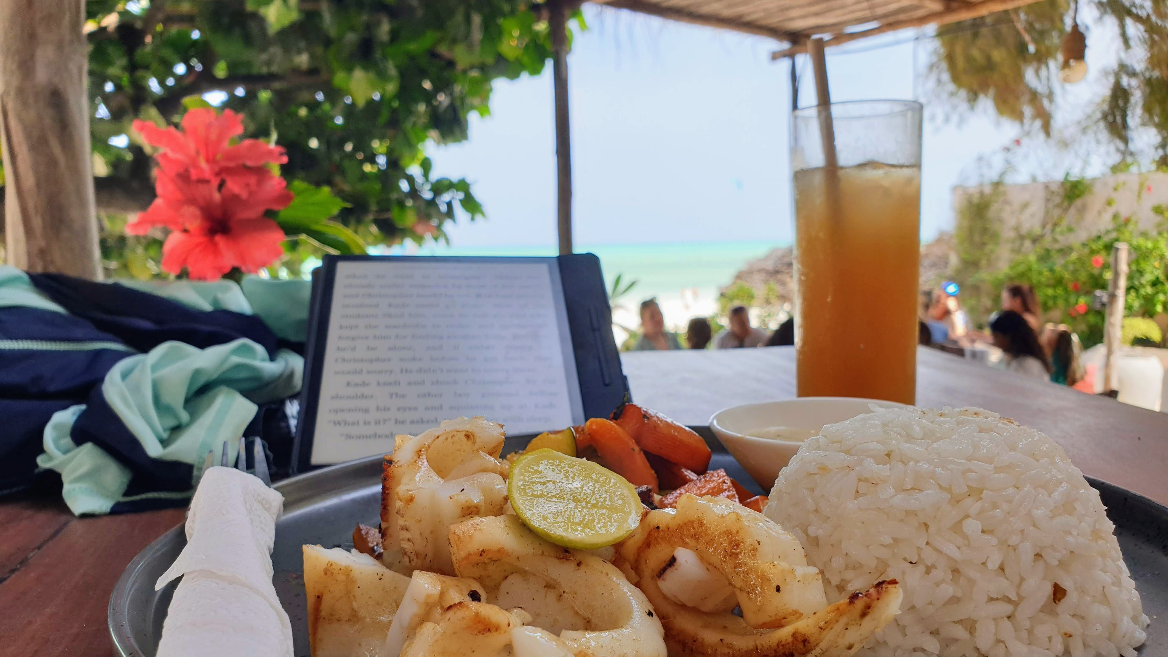
The whole next day I felt like a molting reptile. I knew for sure I couldn’t go swimming until they had some time to heal or else I’d be risking infection. Can I just reiterate how horrible sunburns are, and that with the UV index of OMG sunscreen isn’t always enough? Long sleeves and pants may not be the most fashionable swimwear, but they save not only your skin, but your vacation as well. I spent all that day lounging in a beachfront café ordering drinks and snacks every so often while reading my eBook and watching the ocean. I won’t say that it was a waste of time, because I don’t think any time spent with that view can be wasted, but it would have been more fun if I could have done some of the water activities.
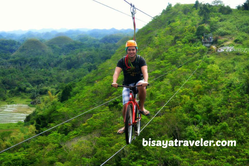
Paje is famous for the beach and the kite surfing. I was interested to try it out. I went parasailing in Mexico. I was able to do a scuba dive in a single day in Aqaba, and I’ve gone caving with guides and minimal training in the US and New Zealand. All those activities can take years of training and practice to master, but can also be done in an afternoon at the beginner level. So when my skin recovered enough for me to be willing to go in the sea again, I sought out the local instructors thinking it would be similar. Nope! The school offered classes that cost 60$/hour or more and said that it usually took students 10-12 hours of training on land before they were even ready to get in the water! There was simply no “try it out for beginners” option available.

Kite surfing is like wakeboarding with a parasail. You have a wakeboard which is a shorter, wider version of a surfboard, and you are harnessed into a thing that looks like a parachute (all those kite looking things in the photo). The wind then pulls you across the water. Some of the windsurfers were even lifted into the air by the strength of the wind. The water at Paje is extremely shallow, so for the most part the kite surfers were skimming over water that was no more than knee deep. However, the kites and lines are pretty expensive, so I imagine that the schools and rental shops don’t want to risk the inexperienced dropping on and having it fly off or get drenched.

The sales pitches on the beach were different from those in Stone Town. There were two main groups of people on the beach selling stuff and they were strongly divided by gender. The men were all dressed as traditional Masai from the mainland. I know at least some were because they also had the body scarring that goes with the Masai cultural milestones, but there’s a portion of locals who adopt the dress code to play on tourists. They are referred to as “Fa-sai”, btw. Real or Fake, the men are gregarious but polite. They would greet me and start walking along with me. The conversation would begin with small talk, asking where I was from and how long I’d been there, then slowly it would move into the sales pitch. The things they had on offer were very much the same as the Masai themed shops in Stone Town. The ladies were almost all in conservative abaya and hijab coverings, and were less likely to follow tourists or engage in small talk. They were peddling massages, hair braiding, and henna tattoos.

Jozani National Park
Jozani is the only national park on the island. It’s part of an environmental conservation movement to preserve the local ecosystem and rare species. Plenty of locals would happily tear it all up for lumber and farm land, so paying for tours helps fund the park as well as the economic projects that run in tandem with it to provide other means of earning a living for those who are being asked not to use the land. It was on my wish list for Zanzibar from the beginning, but I had been on the fence about it since discovering my sunburn. Then, one morning at my hostel’s breakfast, I started talking to a young man about his AbFab phone case (so rare I find a fellow fan these days, sweetie darling). He turned out to be working on his PhD at the Jozani forest. Hearing him talk about the forest and his work gave me the push I needed to get up off my beach bum and go do the thing.
I learned from some folks who’d been in town a while that I could get to the park via the local bus (called Dala Dala) which would stop at the nearby roundabout. There was no bus stop or any signs, so I waited in some shade and watched the locals. Before long a minivan pulled up in front of a small shop and people started rushing to board. It wasn’t hard for me to get in line and verify with the driver that he was heading the right way. The driver and money man were absolutely able to communicate with me in English, though mostly used Swahili in general. The men on board moved around so I could have a seat. There are plastic jugs that can be moved around the aisle to make extra seats, and with the windows down there’s a good road breeze that keeps it from being too hot.
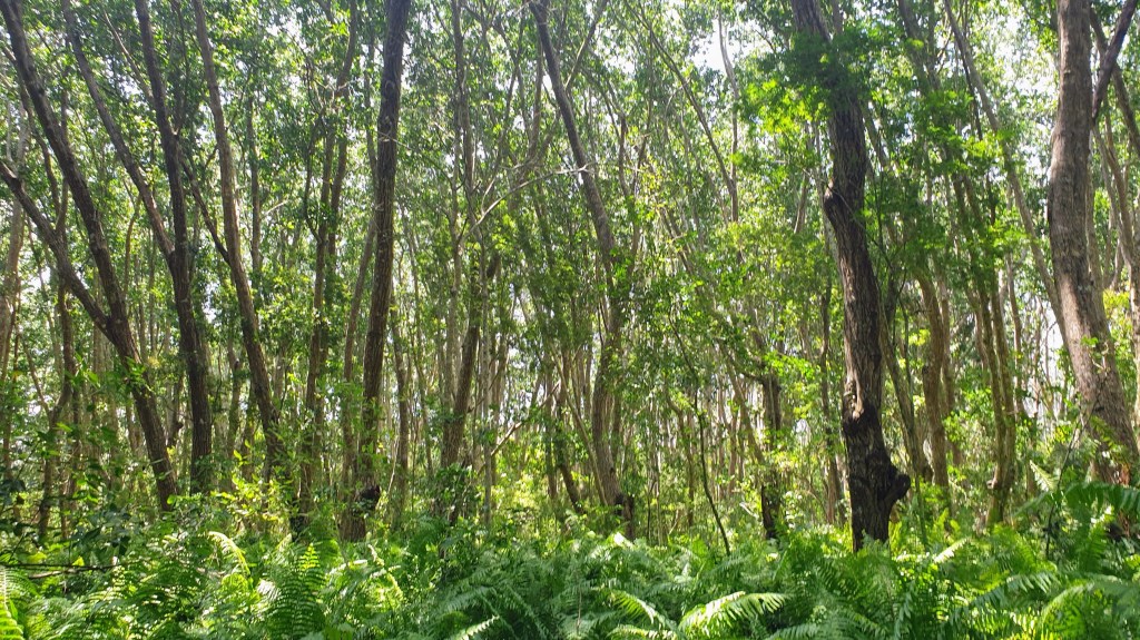
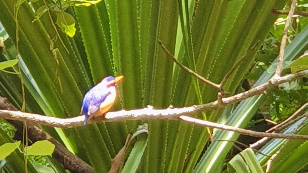
The entry fee to the park is 10.70$ (25,000tzs) and the price includes a mandatory guide. I got a guide all to myself because the only other people coming in at the same time as me were in a hurry and didn’t want to do the whole walk. Their loss. My guide explained things, and helped me avoid looming roots and branches, but didn’t feel the need to fill all the space with talking. Being alone in the beautiful forest with my guide gave me lots of chances to enjoy the silence and see interesting critters. These are photos of the forest itself (some native trees and the remnants of a colonial mahogany plantation) and 3 of the 4 wildlife species I got to see on this part of the walk: millipede, skink, and kingfisher (the larger lizards were too fast to photograph).


The forest is home to two species of monkey: the more common Sykes and the totally rare unique-to-this-one-island-in-the-whole-world Red Colobus. After we walked around the forest for a while, we went to the area inhabited by the monkeys. The Sykes are very un-shy and enjoy coming down to the ground or low branches to look at the tourists. There are signs warning visitors to stay several meters away from the monkeys at all times, and the monkeys clearly do not wish to obey. It was actually impossible to keep my distance from the curious critters, but they never came so close that I was worried about having my phone snatched.


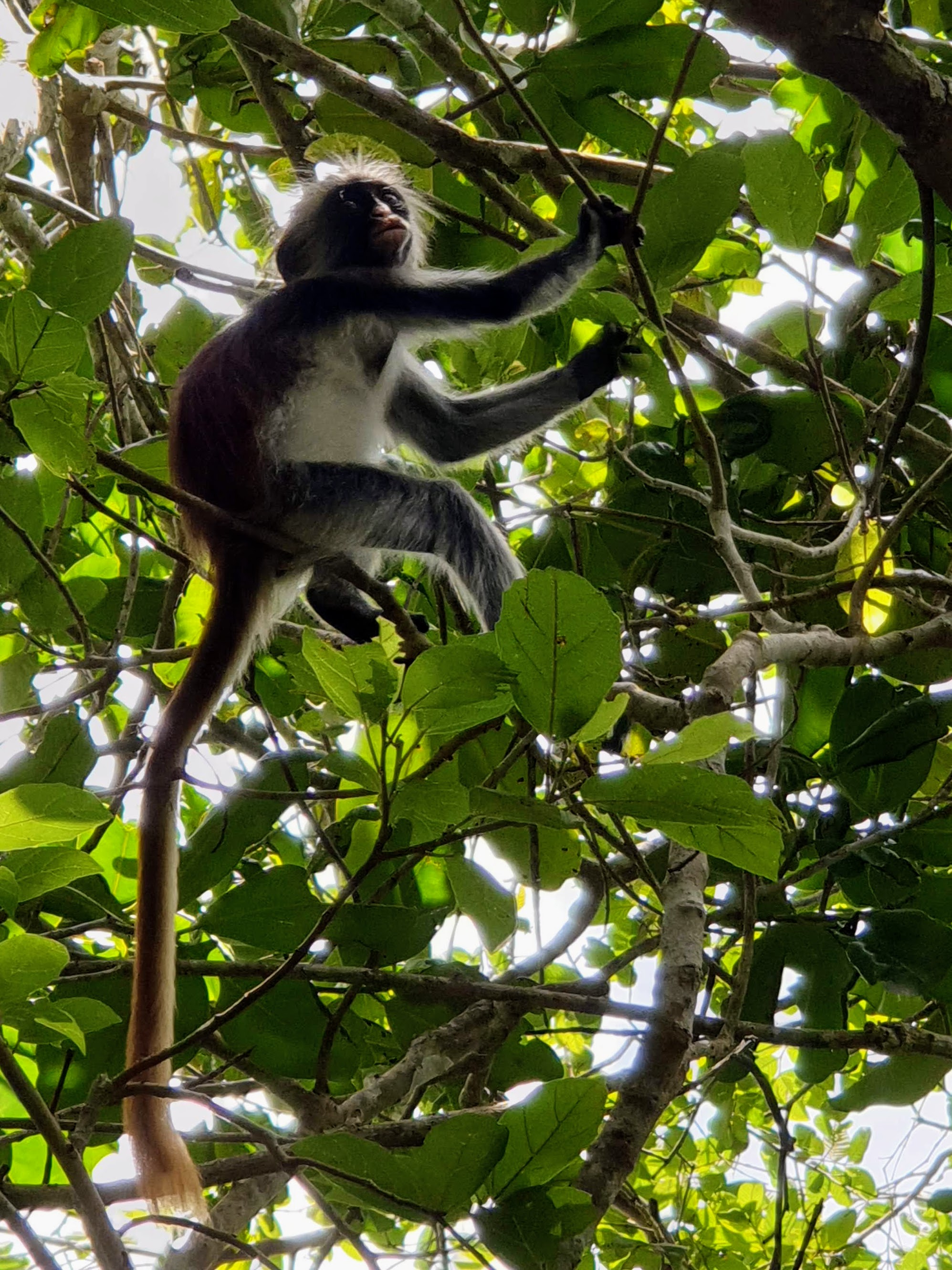
The Red Colobus on the other hand are more reclusive, more arboreal, and just generally harder to find. The guides text each other with location updates so visitors won’t miss out. When we came upon the tribe that had been located for that day, there was another rather large group of tourists being loud and shoving selfie sticks towards the upper branches. I did see one guide gently push a tourist back who got too invasive, but overall, the animals were far enough above us that they could have run off if they were really annoyed. Maybe human tourists are not more annoying than baby monkeys? I didn’t have a selfie stick for phone extension, but I think I got a couple cute photos anyway.


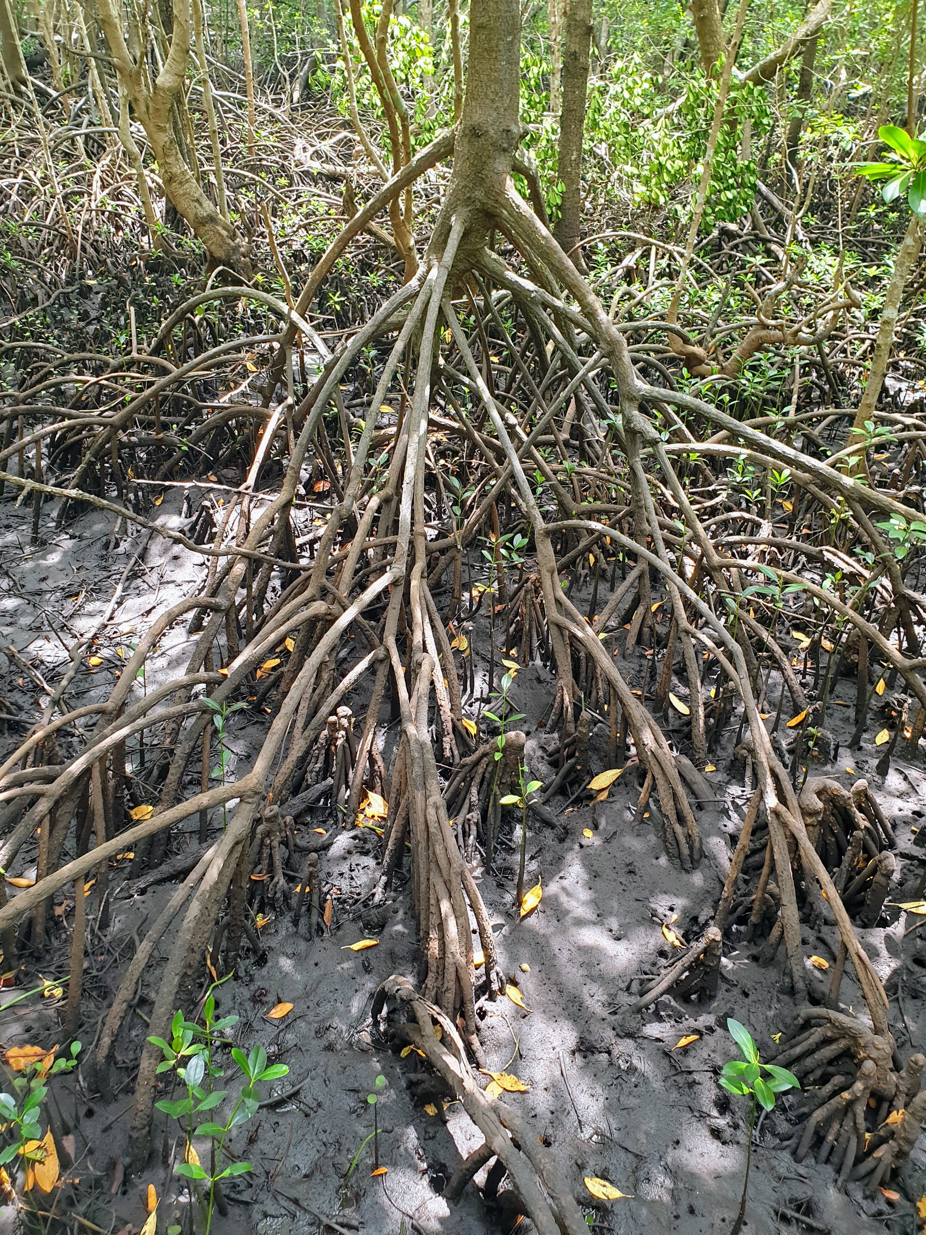
The Jozani mangroves are a little more than a mile away from the main entrance, and my guide seemed flummoxed when I said I’d used the public transit and didn’t have a car or driver waiting to take us over. Quick on his feet, he went to get his own motorcycle to drive us there. Nothing like riding helmetless on the back roads! We made it safely, though, and I got to see the mangroves at low tide (a recurring issue of this visit) which is actually kind of cool because all the roots and crabs that would normally be underwater are visible. I’d like to suggest “low tide mangrove” as someone’s next Halloween theme.


The Butterfly Park isn’t technically part of Jozani, but the entrance is quite close to the mangroves and my guide offered to drive me over and wait while I looked around (very kind offer). It’s another conservation area that’s also working to help employ and educate nearby villagers to help them have income that comes from environmental preservation rather than income that destroys the environment. They breed and release several native species including the bush babies, many butterflies, and chameleons. The cost for tourists is 18,000 TZS (about 7.50 USD), but locals can enjoy it at a hefty discount.
The butterfly guide told me about the work they are doing with the nearby village, the local school, and the forest before giving me the chance to hold some infant bush babies. Squeeee! I don’t normally go in for handling wild animals, but these are a domesticated pair they’re using for education and promoting the conservation. They were entirely comfortable climbing on me (yeah, that’s my pasty white arm in the photo) and were so cute!! As a species, bush babies are usually asleep during the day (the adult pair sure were) so tourists don’t get to see them in the forest and don’t realize there’s more than monkeys being protected there. These fuzzy lil’ ambassadors help raise awareness of the breeding program and need for environmental conservation.


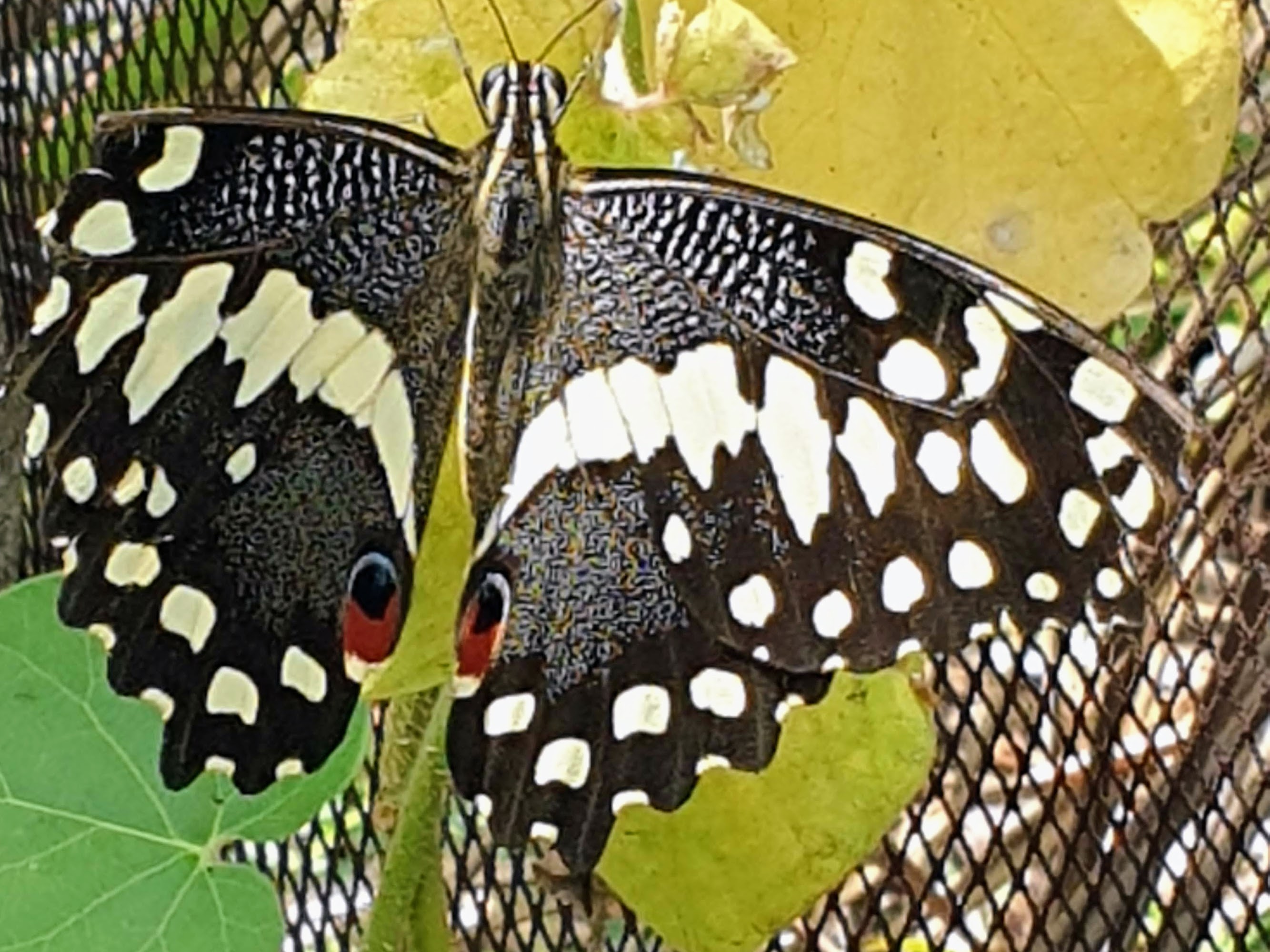
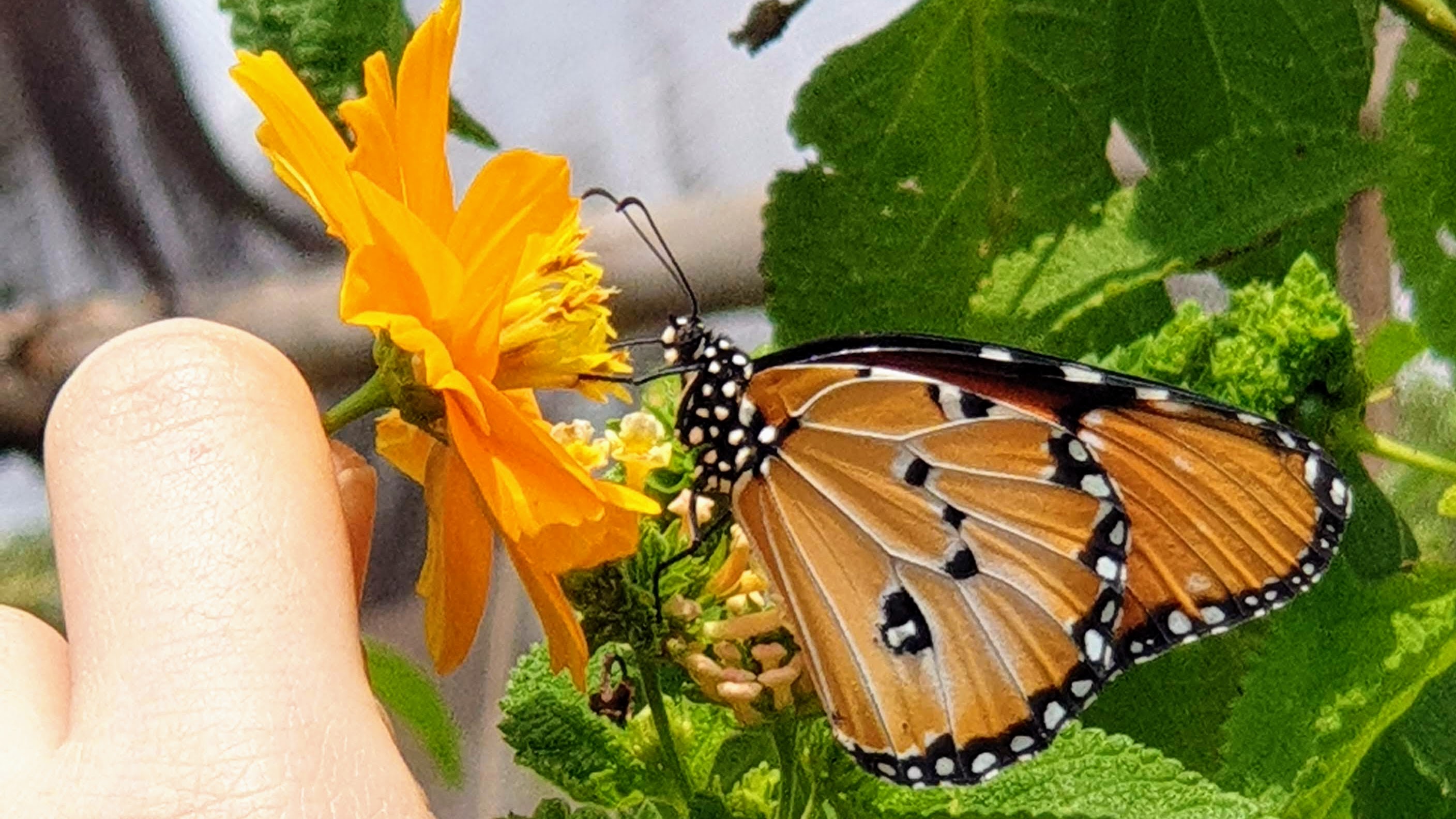
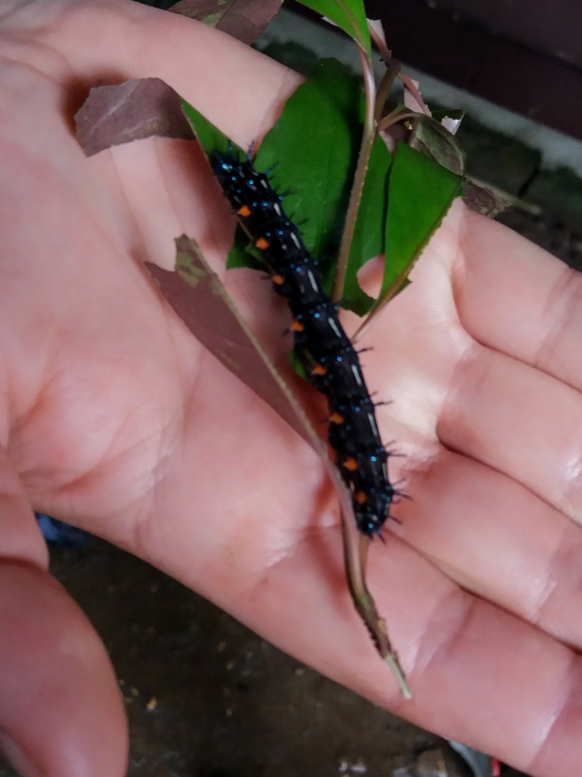
Next we moved on to the butterfly breeding program. In addition to helping the furry species, they are helping the flutters as well. They are much needed pollinators and beautiful as well, but their breeding environments are often under siege by human development or by displaced predators. This park helps breed pollinators year round. As an ongoing part of the hands-on education, I got a handful of caterpillars as he showed me the 4 species they have this time of year (it changes seasonally) at egg, caterpillar and chrysalis stages. We then entered a small enclosure where the butterflies are safe from predators and breeding efforts continue.


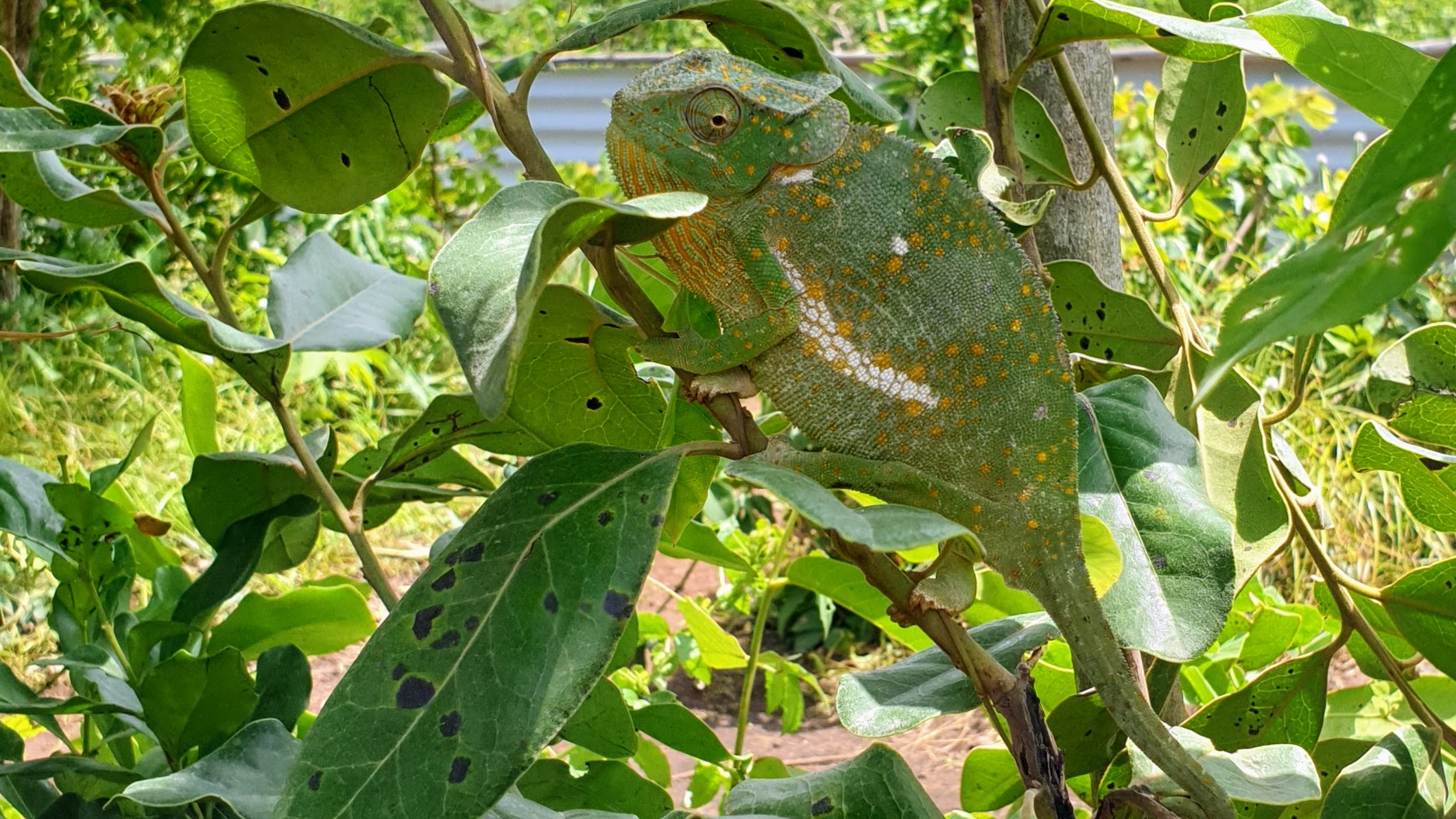
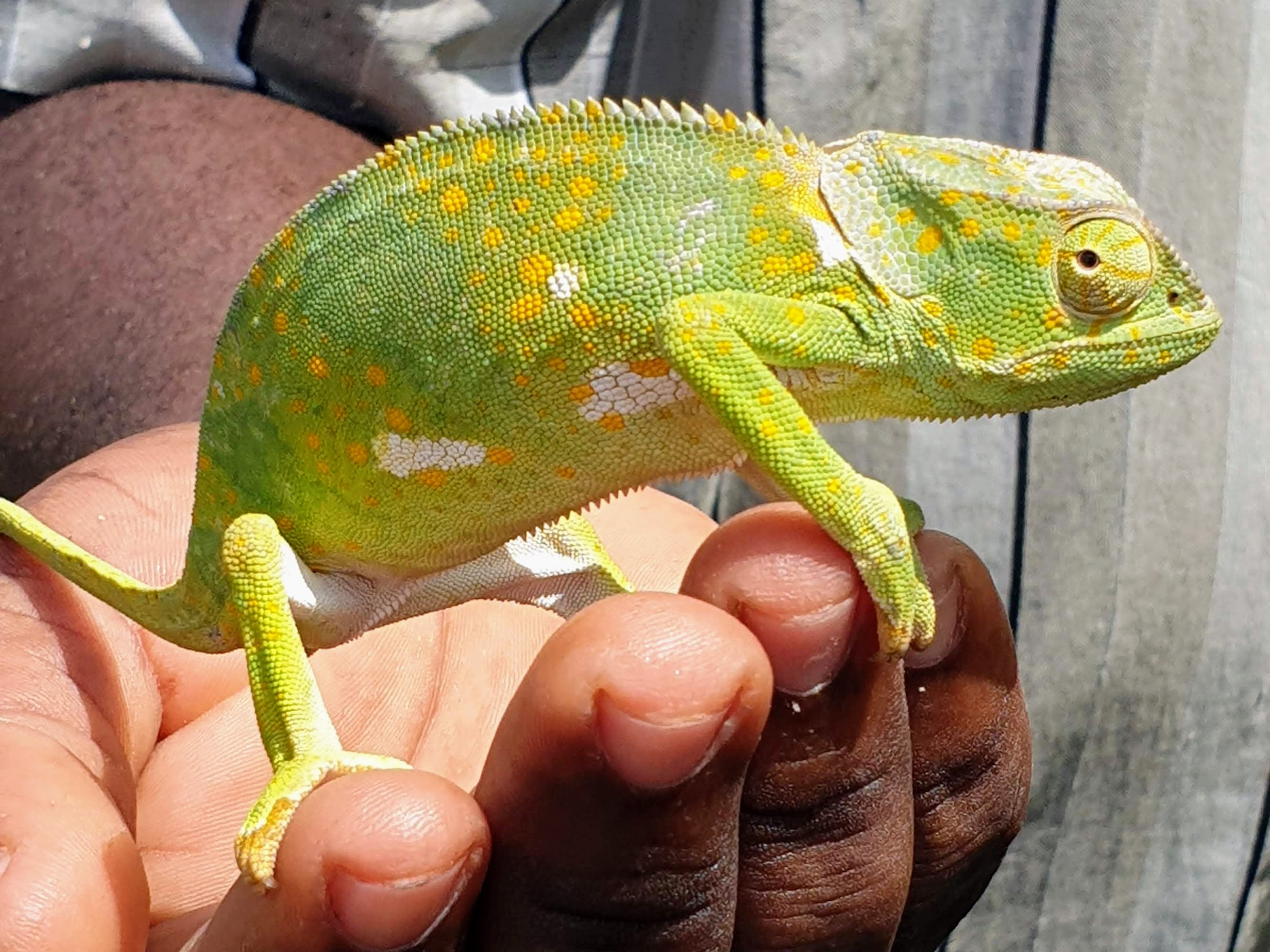
The tour concluded with the chameleon enclosure, although they didn’t need any netting, and were content to hang out on some trees which were roughly segregated by a low fence. I love the way they always seem to be giving a disdainful side-eye.

The Local Economy vs The Tourist Economy
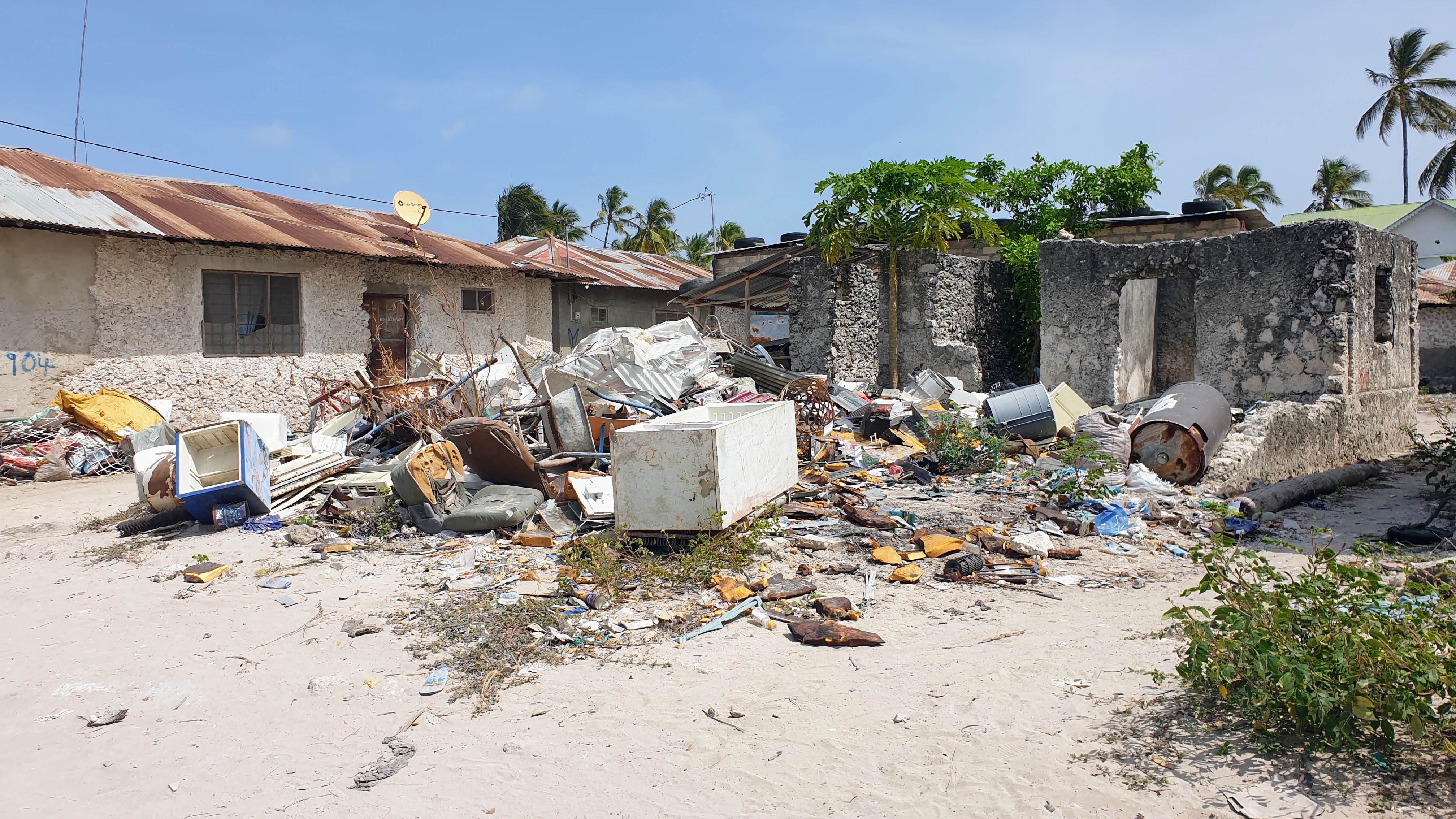
The whole time I was in Zanzibar, I was in shock at how expensive everything is yet how little the average person lives on there ($150-350USD/month). Walking though the local village to get to the resorts in the beach was a real eye opener. The homes don’t have running water, there’s a well and I saw young girls walking to and fro with large buckets. People are cooking on fire. Plenty of cows, goats, and chickens around. Tiny fruit stands and dry goods shops. Places that look like ruins but are actually houses. Then the beach 300m away with luxury resorts.
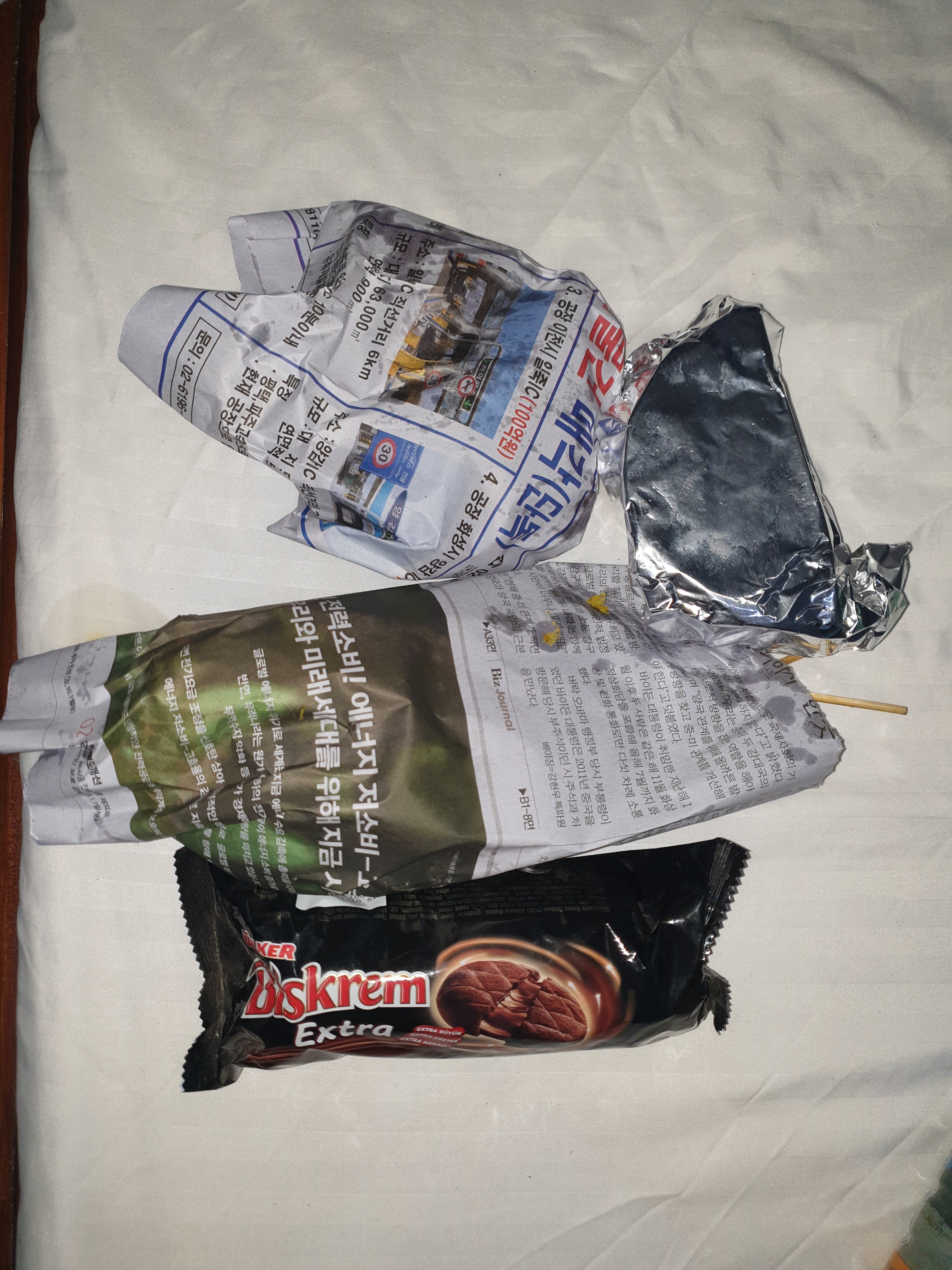
I ate about one meal a day at tourist restaurants and the quality was nice. Tourist and especially beach restaurants are known to be expensive, but most were less than 25$US for a nice meal and drink, which is not a bank breaker. One night in Paje I decided to try the local street food up on the main road. I got grilled meat skewers, samosas and fresh pineapple slices (all wrapped inexplicably in Korean newspaper for takeaway) for about 2$. Filling and tasty at 1/10 the cost of a meal at a restaurant. I’m used to street food being less, but woah! It’s not just beachfront vs main road either. There’s a place less than 30 feet from the actual street food that calls itself “The Street Food Court” which has several takeaway windows and a common seating area. I tried to go there for lunch earlier and saw that most of the dishes were still in the 10-15$ rangeY yes less than the beach but still 5+ times more than the actual street food!

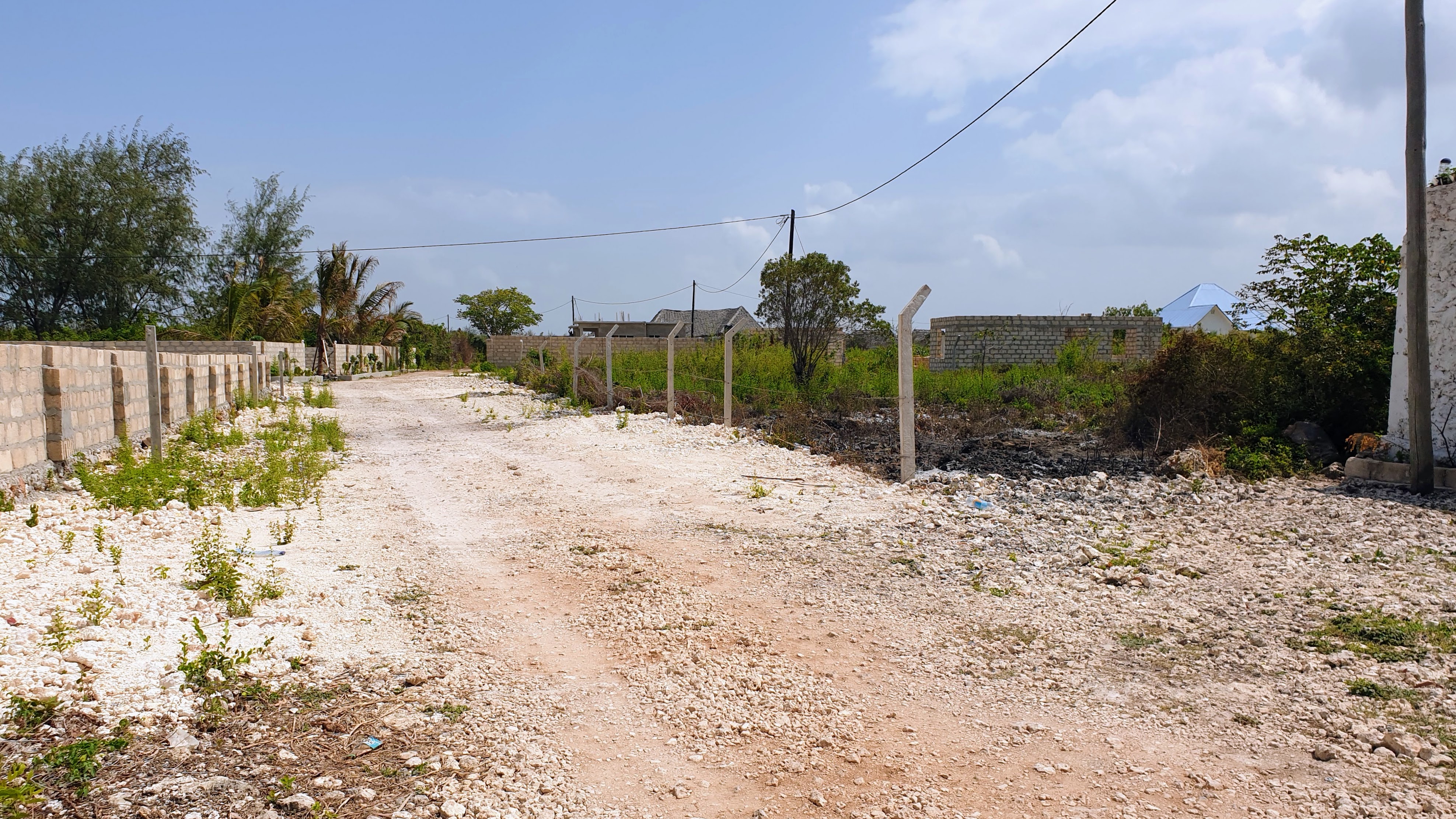
Then there’s the taxis. There’s no “taxis” in the drop fare charge per mile sense. There’s drivers with vans and special licenses who will take you to places around the island but rates are negotiable. 15-20$ to get from the airport to Stone Town (7-8km), 30$ to go from Stone Town to Paje (50km), 25$ to go from my hotel in Paje to my next one in Menai Bay (27km). The driver at the hotel wanted 40$ round trip to go to Jozani, and the ones out in the taxi lot wanted 50$! For 43¢ each way, I was able to use the public transit. 1/100th the cost of the taxi? I’m used to buses being cheaper but that was next level. (My view from the back of the bus)

Maluum Cave Spring
Another wish list item was the cave pools. I visited one of those in Bohol after my terrible sunburn there and it was ah-maze-ing, so I knew I wanted to do that again with my new sunburn. There are a few caves around the island with natural swimming pools, including one rather famous one about a 10 minute drive from my hostel called Kuza. It was highly reviewed online, and I was trying to figure out how to get there what with all the taxis nearby wanting 30$ to go a few kilometers. Then I met yet another traveler over breakfast who told me about a hidden gem: a little cave pool just one kilometer away that was almost unknown!
This sounded appealing both because of the shorter distance and the potential lack of extreme tourism that had been slowly eating my brain since my arrival on Zanzibar. I looked up the place online and noticed that they had time slots and only allowed a limited number of people into the pool at a time. They also banned sunscreen and other skin/hair products that could harm the ecosystem and provided showers for people to clean off before swimming. It was a level of dedication to ecological preservation that I appreciate everywhere, but had come to see as rare on the island where tourist money was a bigger priority for most than the environment.

I walked the 1.3km rather than trying to navigate the local bus. I’m sure it could have been an option, but the walk was interesting because it gave me a chance to see more of the area that isn’t curated for tourists. Maluum cave is set back a bit from the main road, so the last bit of the walk took me through undeveloped lots on back roads through fields alternately overgrown and filled with construction debris. Like so many things in Africa, the outsides tend to look somewhere between “plain”, “run down”, and “oh god oh god we’re all gonna die”, but the insides can be quite luxurious.

I was greeted at the gate by some young men in Masai garb and checked in at the registration desk. There was a big group that arrived at the same time I did, and I was disappointed when I realized that we’d be sharing the pool because they were very loud and energetic and I was riding the quiet forest & beach bum vibe of the last few days. Thankfully, they were also running late on whatever tour they were doing, so they basically got into the water long enough to take some selfies and then trundled back out leaving me in the pristine natural beauty all by myself.


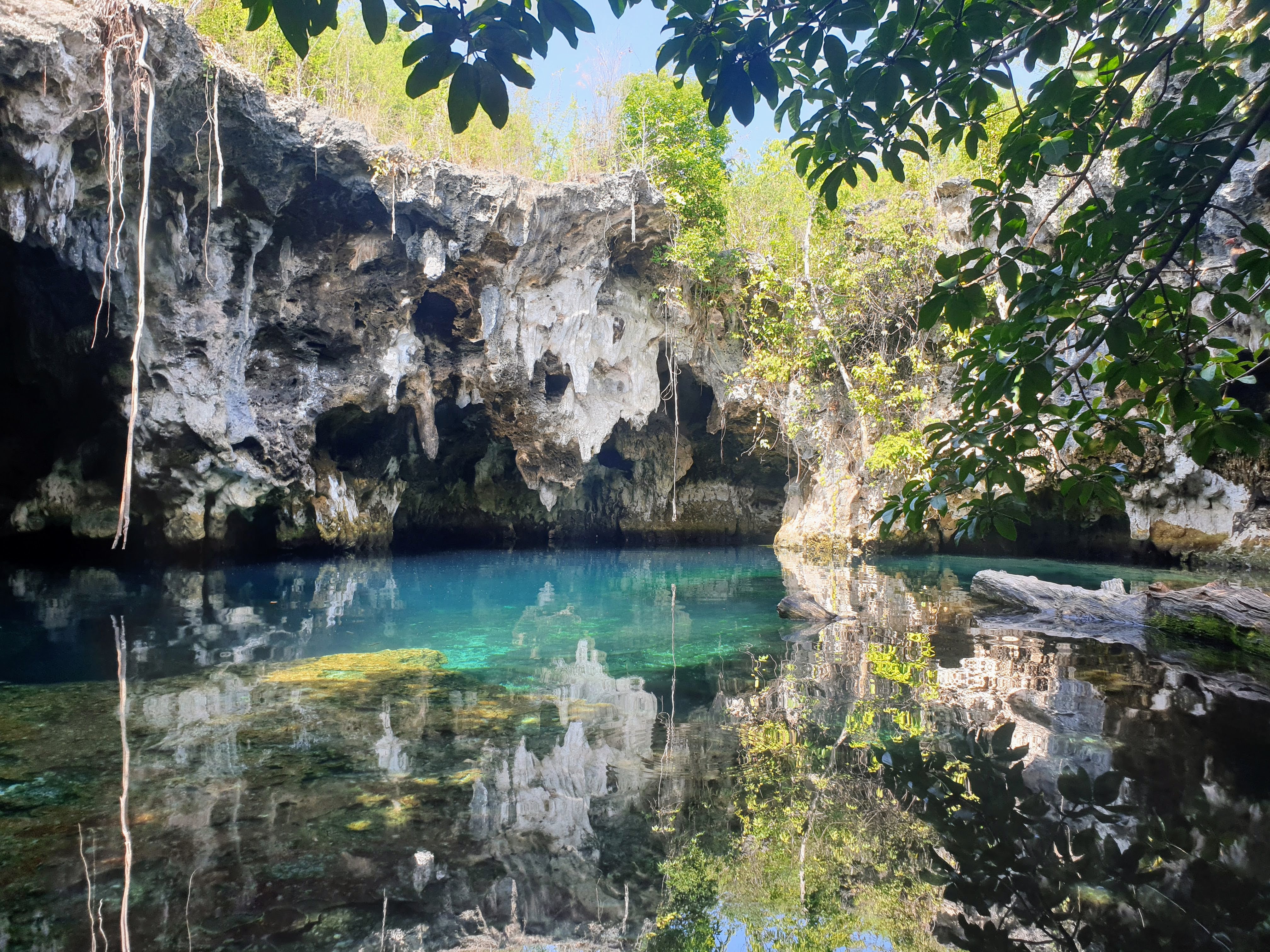


I didn’t have it to myself for long, but I saw a purple crab, several little fish, and had a short staring contest with a hornbill. Unfortunately, the waterproof case I’ve been using since 2017 finally died that day, so I was only able to take photos while out of the water. The next group that came through shared my calm vibes and I had gotten some time to commune with the nature on my own, so I was happy to share and enjoy the company until the staff signaled my reserved time was up.

They have a restaurant on site as well, so I headed over there for dinner and to air dry before changing back into my street clothes for the return walk. I had green banana curry for the first time. I have had dishes made with green plantains (a banana cousin) which cook a lot like potatoes, but I had never thought of using actual bananas while green. It was delicious and the banana flavor was not at all overwhelming. The weather had cooled somewhat by the time I left, and I had a leisurely walk back to my hostel for my final night in Paje. Here are some cows I passed on the way.


Aside: Due to the current situation in Dakar (where I’m living), I’m adding a little note to let you all know I’m safe. I plan on writing a full post on experiencing this historic unrest in West Africa’s most stable democracy first hand, which I’ll likely publish after my triumphant return to America in August. Until then, I am in a quieter neighborhood with no strategic targets. I have food, water, electricity and a working VPN. If you’re curious about what’s going on, you may have trouble finding details in English, but there’s a lot French resources available and Google Translate is good enough. I recommend searching terms like “manifestation” (French for protest or demonstration), Sonko (the political candidate at the center of the controversy), and of course the popular hashtag “Free Senegal”.


")


 However, when Finn saw Benadonner crossing, he realized the giant was much bigger than he previously thought. He fled the coast, retreating into his home. His wife Sadhbh (omg Gaelic, amirite?, that’s probably pronounced “Saive”, maybe?) heard what he’d done and quickly dressed her husband up as a baby.


 At first I didn’t know what they were. I only saw the bright colors from a distance and was drawn closer with curiosity. As I examined the strings of color, it became clear that these were chains of paper cranes folded and strung together in a way that most Westerners are familiar with from the story of


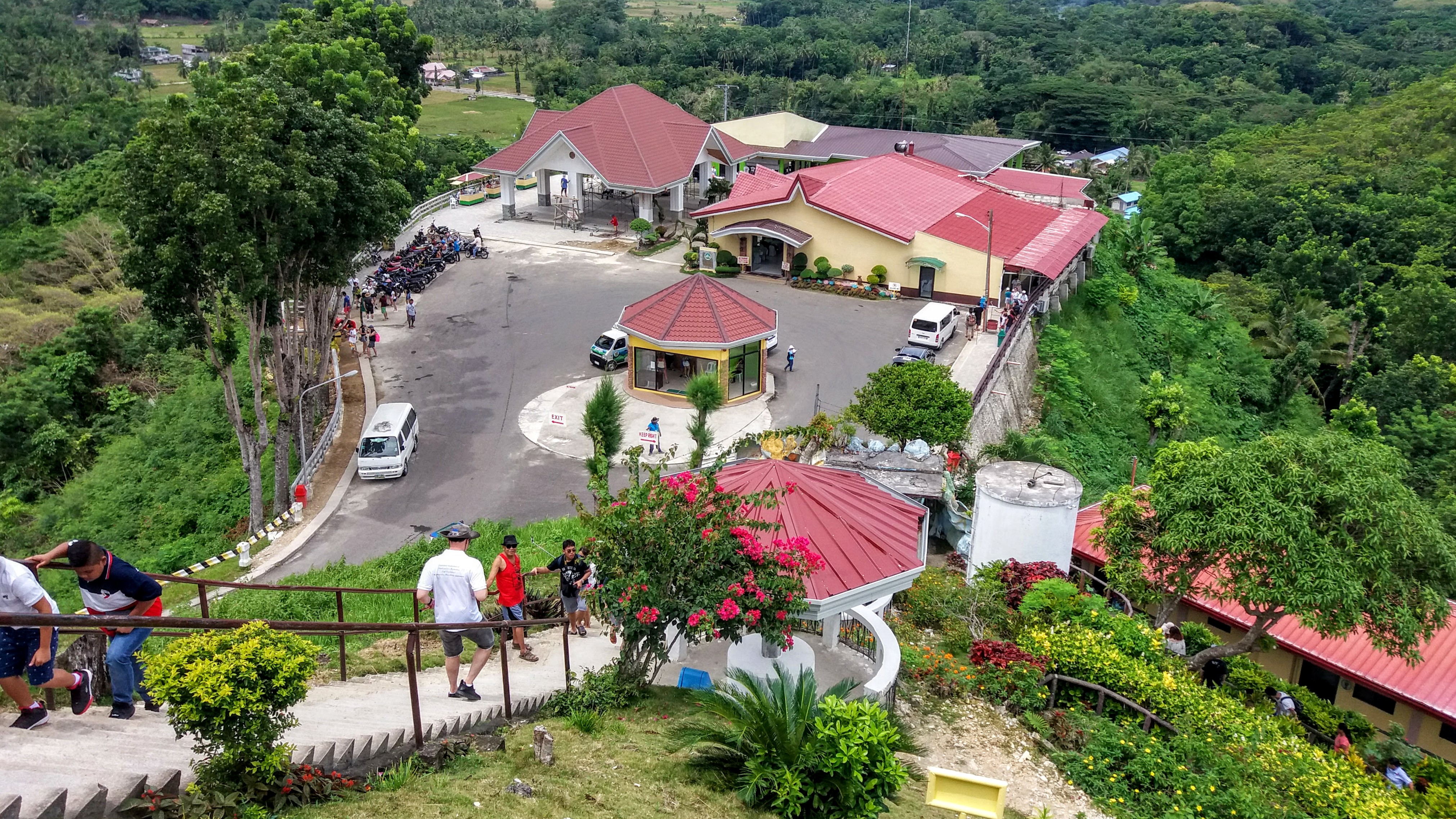
 After 2 and a half hours of driving, we finally made it to the Chocolate Hills Lookout (sometimes called the Chocolate Hills Complex). There was a line of cars and vans stopping at something on the way, but they all looked like tourist groups and there were no clear signs, so we just drove around them and on up to the parking lot at the top. Motorbikes always have a separate parking area from cars here, so we pulled in and were asked for our tickets… which we didn’t have. I’m not sure if that was what we should have done in that long line of cars or not, but it didn’t seem to bother anyone, we just gave an attendant the money for the parking and tickets and she returned with our passes and receipt. We left the bikes there, and although we had to leave them unlocked, the lot was watched so we weren’t too worried.
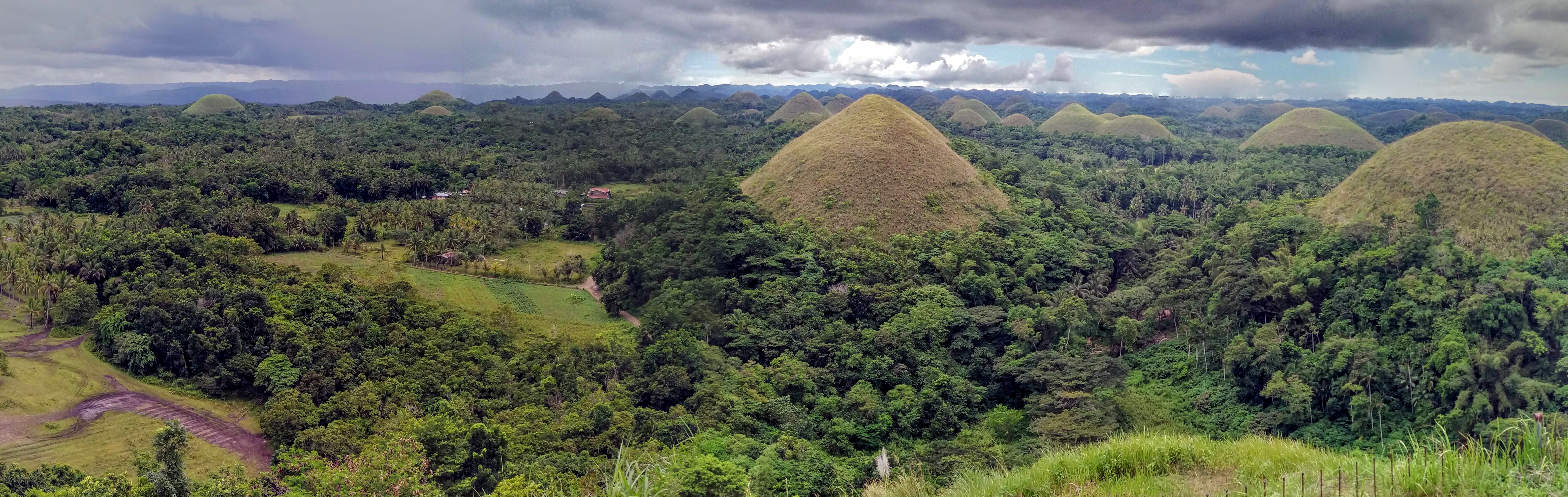
 When going to view the Chocolate Hills, there are two main scenic points, the one I went to, and another on the opposite side called Sagbayan Peak. The descriptions I’d read online make Sagbayan seem like a great place to go with kids, with a water park and giant animal sculptures and other places to play, but after a 2.5 hour drive to the Complex in Carmen, I opted not to drive to Sagbayan as well. There are other places to get a view, and there are some ATV rental places you can do an off road drive in the area, but it seems like the best way to be sure of getting a nice look is to go to one of these two peaks for a high ground advantage.
 Once we completed the survey of the base level, we headed over to the stairs. I’m not a champion stair climber, but there were lots of places to stop, and a few side paths for extra sights. It’s not too much of a climb for all that it’s the tallest of the hills. Part way up is the turn off to see the “Our Lady of Lourdes” Grotto. The Philippines are mostly Catholic, a holdover from the Spanish colonization. There are churches and shrines everywhere, but I don’t mind too much as Catholic art tends to be beautiful, and no one was trying to convert me.
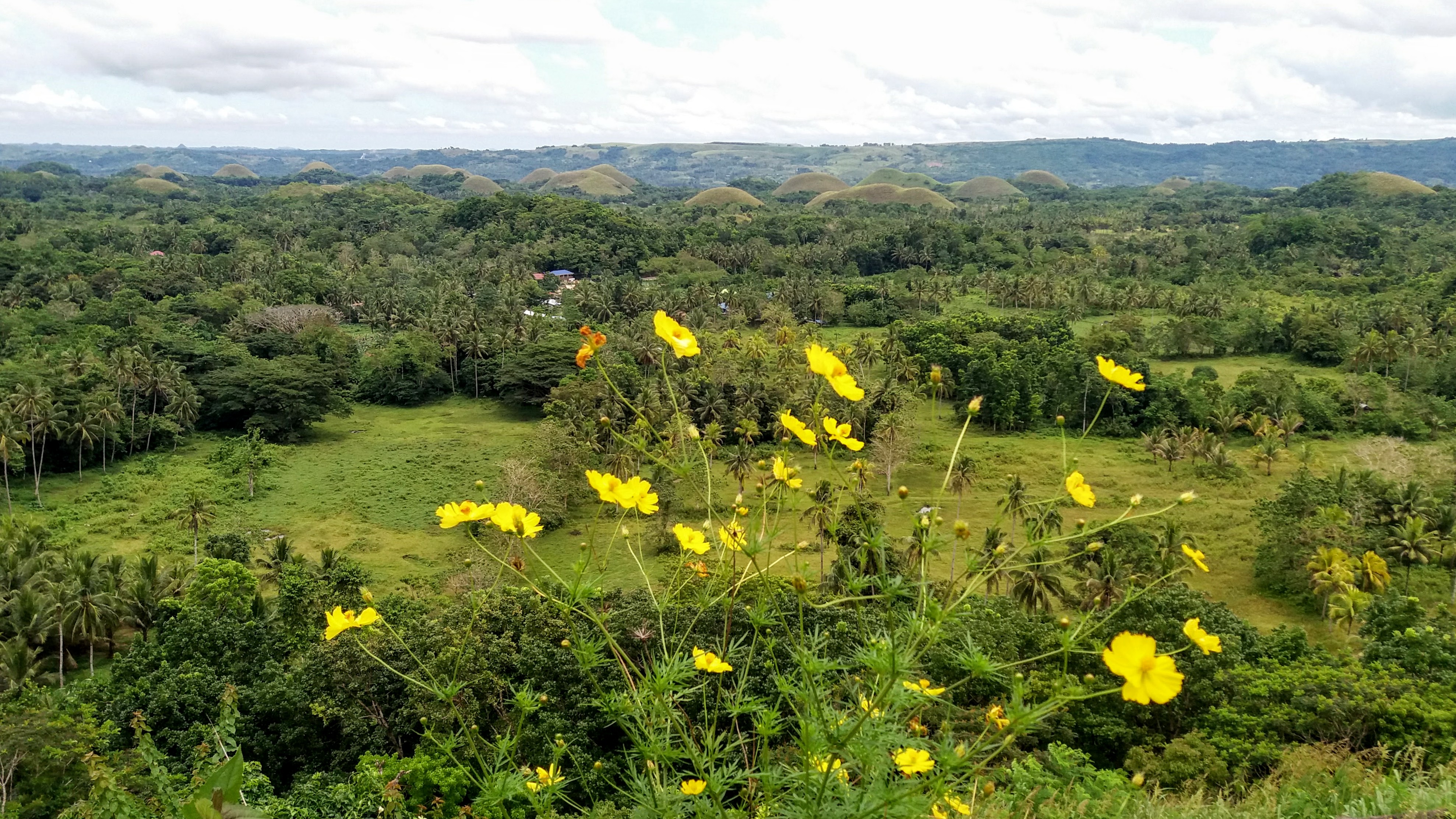 I took about a million pictures of beautiful flowers and the shifting view on our way to the top. And when I finally reached the peak, took obligatory selfies from the viewing platform. I also went to find the not-actually-famous-at-all well with a a bell to ring the bell and make a wish. There was also a cute little backdrop on one side for people who like to pose with man-made scenery. I liked it despite or perhaps because of it’s total kitsch, but I’m glad it was off to one side and not covering the whole viewing platform.
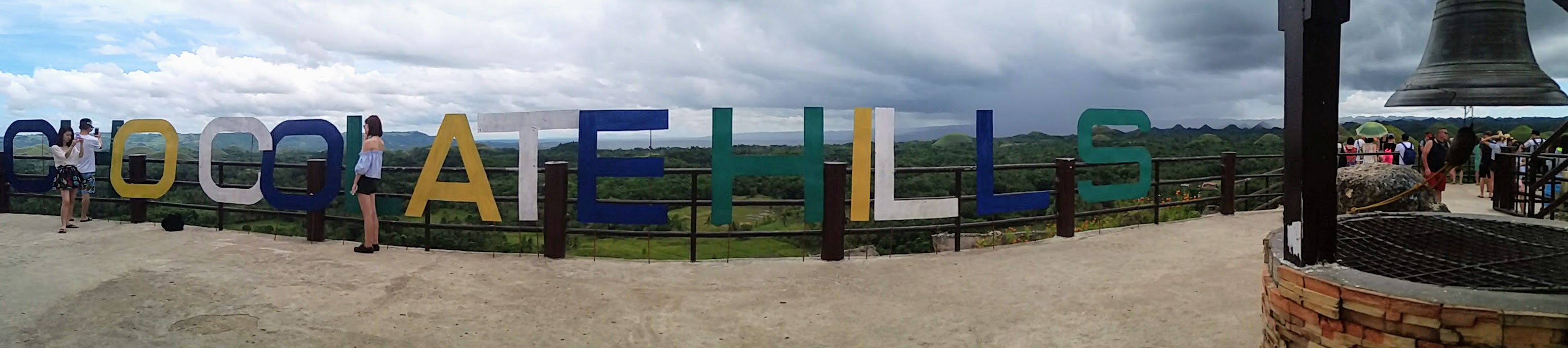
 Even as the week continued, we experienced very little rain. I am told that the rainy season is short but has strong showers every day, and the hotel hostess did say that the weather was a little unusually dry for my visit, so maybe I just got lucky? Anyway, not wanting to be caught on the very top of the highest peak around if a thunderstorm hit, we began to descend the stairs.
 One of the many things I found online about Bohol was the prevalence of adventure parks. We have these in Korea too, and for some reason I still haven’t ziplined. The Chocolate Hills Adventure Park advertised a kind of zip bike, where you pedal a special bike (with a safety harness) along a zip line between two chocolate peaks. I have nothing against ziplining, it just doesn’t seem like a great way to actually see anything, so I keep putting it off in favor of taking in sights until I manage to find one in a place I’ve thoroughly explored. But this bike thing seemed unique and slow enough to get a great view with plenty of time to look around and admire the scenery instead of zipping through it.
 I read online that the park had a weight limit, but we decided try anyway and see how much they actually meant it and how much was just a liability disclaimer. It turned out to be sort of both. We were each a few kilos over the weight limit, but instead of telling us straight up “no”, the staff advised us to head on up to the zip bike area and try on the harness with the safety guide to see if it would fit anyway. In retrospect, I’m not sure if this was their way of shifting the responsibility or not. I think if we’d been WAY over the limit they would have turned us away, but since we were close?
 We headed further in, following signs to the zip bike and were led to a steep stone stairway with the sign “fitness test starts here” at the bottom. I theorized that anyone who couldn’t climb the stairs to the starting point wasn’t fit enough for the activity, and we began the ascent. Whatever your opinions of stairs are, know that the jungle makes it harder. Humidity. Nonetheless, we persevered and made it to the top and were rewarded with a breathtaking view and a less than stellar ride attendant. I do try to give people the benefit of the doube, and maybe she was annoyed with her coworker on the radio or something else we couldn’t even see and not with us at all, but it was clear she was annoyed with something.
 We waited on the viewing platform, and I have to say that even though we’d just come from the tallest peak in the hills, the Adventure Park’s view was stunning. I don’t think I would have gone there only for the view, but it was certainly a nice perk. We also watched a few more tourists take the bikes out and back on the lines from the tower above us to the hill next door. The attendant at first told us that we had to wait due to lightning (the storm that had just passed us?), but then we saw people riding anyway? I’m not sure what was the deal there. I also accidentally got doused in ants trying to take a picture of the hanging trellis flowers. The ants really liked the flowers too, and when I bumped into one, they transferred from the petals to me. Thankfully, they were just small black ones, and I was able to brush them off with no bites, but it reminded me to keep an eye out for what I touch or lean on in the jungle.


 If you’re going to the Adventure Park anyway, go ahead and visit their butterflies, but don’t go out of your way for this display. We were accompanied by a guide who had been trained to take lots of pictures for us (with our phones, they weren’t trying to sell them back to us or anything, but Asian tourists especially love appearing in their own travel photos in a way I never will) and move people through. She showed us a display on the life-cycle of a butterfly, and we got to hold a caterpillar. Then we walked through a path in a netted off part of the forest. We only saw a couple butterflies and at one point our guide threw a rock in an attempt to get on up on the top net to fly. We quickly stopped her from continuing that and said we were fine with the way things were. She said the butterflies were inactive because of the rain, but I felt like I’d seen half a dozen just climbing down the stairs from the zip bike.
 After the butterfly enclosure, we were guided over to the suspension bridge which is included in the park entrance fee already. This kind of bridge through the canopy is another very common tourist must do in Bohol, available at multiple locations. Even though I may not deliberately go looking for the silliest touristy things to do, I’m hardly going to turn it down if it’s right there in front of me. We had fun, and got a nice view of the park from the air before descending the stairs on the far side and heading back to the bikes.
 Following a delightful and refreshing stop for some locally sourced buffalo milk ice cream, we headed back down the main road where were would be able to find the Tarsier Conservation Area (not to be confused with the “Philippine Tarsier Sanctuary”). Bohol is also famous as the home of the world’s smallest primate, the tarsier. There are two tarsier spots near the Chocolate Hills, and it was worth it to me to visit both, since I was already planning other road trips near each one. I’ll say now, if you can only do one, do the Sanctuary, but seeing both was nice.
 I can’t be sure if they are placed at these viewing stations or if the park simply made attractive bowers in good places and hoped. I did see one little guy hanging out in a not great viewing spot with no guide to point him out, so at least a few must be slightly rogue. We were also told they are territorial, and tend to stay in or near one tree as adults.
 Whether we like it or not, tourism is the main reason species like these will survive. In fact, the growing interest in ecotourism is a big part of what’s paying for conservation in developing countries. It can be hard to draw the line between exploitation and preservation, but I think the Conservatory is leaning on the right side. Of course, the park dumps you back into a souvenir shop between the exit and the parking lot which was full of tarsier themed everything, and one shelf of wooden phallus ashtrays for no discernible reason at all.
 Several days later on my way to a lunch cruise on the Loboc river, I started out extra early to make time for the Philippine Tarsier Sanctuary to see how it compared to the Conservation Area. I tried to get there as close to opening as possible to beat the crowds of tourists, and I think I very well may have been the first customer of the day since cashiers had to be found, then change had to be found. It’s not an expensive tour, but like every little adventure in Bohol, it does cost a small amount to go in. I got a personal guide who walked me through a kind of netting air lock into the forest beyond.
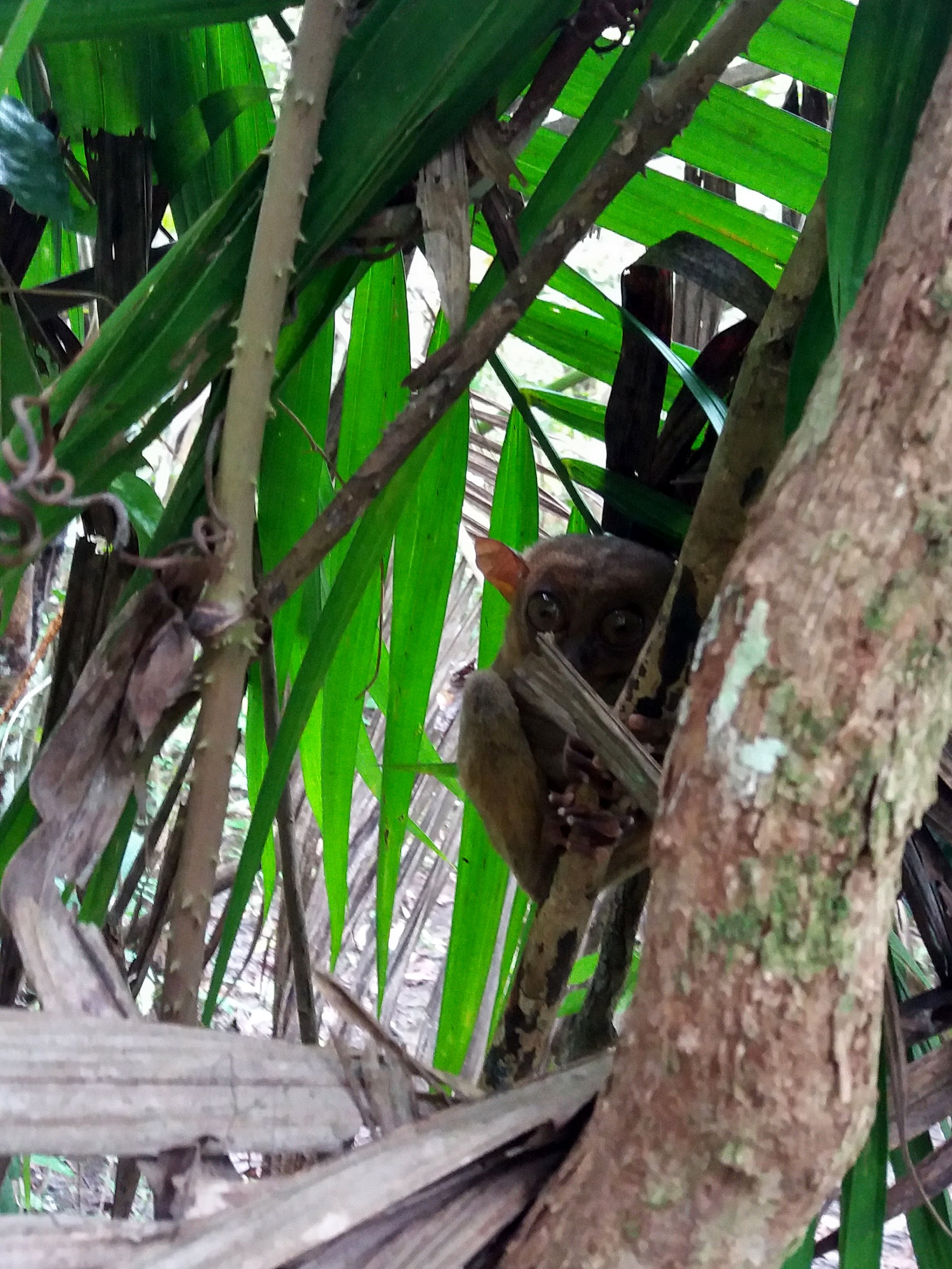 While the Conservation center had been paved paths with guides stationed at each Tarsier, the Sanctuary was much more a natural jungle with mud paths through the trees. I doubt I would have gotten lost in the small area behind the building, but I certainly wouldn’t have seen as many tarsiers without my guide. The Sanctuary is closed in, but the fence and netting are very unobtrusive, designed more to keep predators out than to restrict the tarsiers. I also felt like the tarsier perches here were probably man made to encourage the critters to good viewing sites, and to make sure they were visible from the paths while being sheltered from the sun. However, where the Conservatory perches were obviously man-made, the Sanctuary perches looked far more natural, drawing less attention to themselves and who knows, maybe being more comfortable.
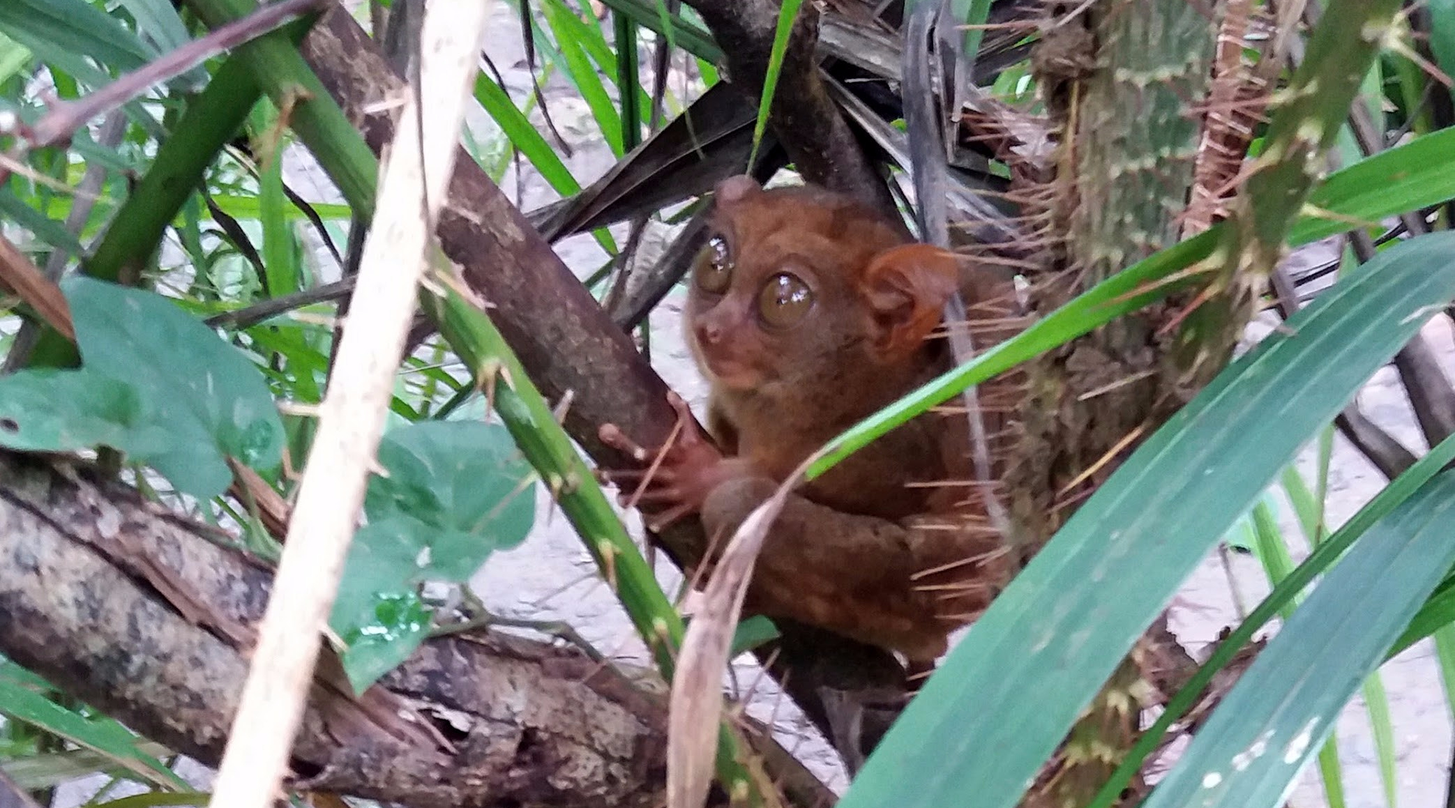
 My guide quietly and confidently led me through the tangle of muddy paths, stopping every few minutes to point out a tiny sleeping primate. I was surprised at how close they were to the path after my experience at the Conservation center. While I’d been hard pressed to get any decent photos at the Conservation center, I had merely to hold up my phone to be close enough for great detail here at the sanctuary. I was worried about disturbing the little critters, so I tried to keep a reasonable distance, although more than once they were close enough for me to have reached out and touched, I know that would have been dangerous and damaging for them, so I resisted the urge. My guide was in no rush, and was happy to stand by while I got a good look at each one, and until I was satisfied with my photos. I can’t say I always had a good photo before I decided to move on, since I was keenly aware that simply by watching me back, I was keeping them awake and didn’t want to become a source of greater stress. I probably stayed at each spot between 2-5 minutes before moving on.
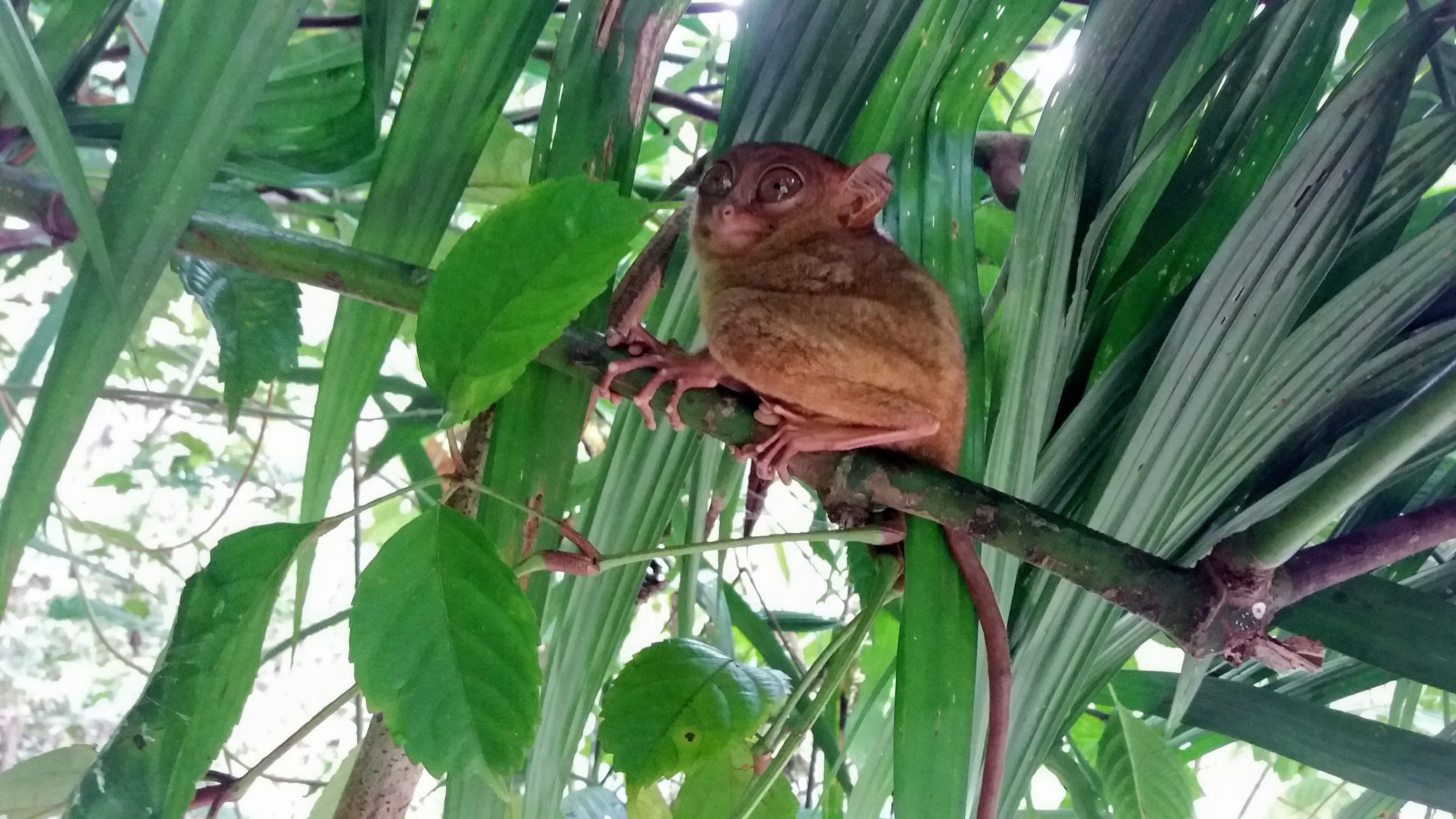 The Sanctuary jungle was also the hottest thing I did on this vacation. The trees were so close together and the netting caught the breezes, so even at 9:30 am it was sweltering hot and I was drenched in sweat the whole time. It was entirely worth it.
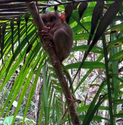 It was so peacefully quiet and there were no other visitors in the park so I felt very special getting to have this beautiful jungle and adorable creatures all to myself. I talked to them in soft reassuring tones like I was trying to sooth a scared kitten, and I have no idea if that was effective at all or just my own human oddness, but it was so obvious that they were watching me back, I couldn’t help but wonder how many myths of goblins or fairies these peculiarly shaped animals inspired. Their eyes are so large in comparison with their heads and yet the gaze is penetrating. Their hands are smaller than a newborn, but their fingers long and deft with large pads at the tips like a lizard or a frog.