Northern Ireland is stunning. I was incredibly lucky to have very nice weather on the days we were exploring the country and the coast, but I can’t imagine it is any less stunning when it’s cloudy and ominous than when it’s sunny and blue and you can see Scotland from the cliffs. This isn’t only wild, untamed scenery. It includes some ruins which have begun to merge with the landscape and some cultivated gardens that show the lovely flowers to their best advantage. In the tradition of saving the best for last, you have to wait till the end to see the Giant’s Causeway.
In Between
There are places in Ireland that everyone wants to go to, me too, but driving from one of those to the next could mean endless hours of highways OR it could mean tiny back roads and mini stop offs to lesser known, but still beautiful sights. Guess which one I chose? Here are a few of the in between places that were added to the itinerary purely because we wanted somewhere to stop between points A and B.
Grianan of Aileach
I almost forgot about this stop. For shame. It was a bit of an afterthought on the day we visited as well. On the road between the Belleek Pottery factory and the city of Derry, we drove up a little side road to find this ring fort. The view from the top is breathtaking, and it’s just my type of mountain top that you can drive up and park on top! There were not too many other people out, but there was a small cafe style food truck hoping to sell some refreshments. There’s no toilet facilities however, so we declined.
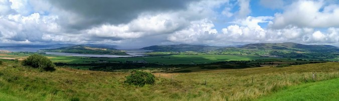
The fort was built in the late 700s-early 800s, raided by Vikings in the early 900s, and finally destroyed around 1100. The restoration project started in 1870 and is protected and maintained by the Office of Public Works today. It’s one of many tiny little treasures that make driving a much more appealing option to bus tours. We only spent about 15 minutes at the fort, just long enough to gasp at the view and enjoy the archaeology.

Glenarm & Glenarife
These two stops were along the west coast of Northern Ireland, after we finished the Causeway and before we arrived in Belfast. Glenarm is a beautiful castle estate (not a ruin) with cultivated walled gardens. Genarife is a beautiful forest hike with a waterfall.
Glenarm Castle is related to Dunluce Castle, a ruin located on the Causeway Coast which I’ll get to that later in the post. The story goes that in 1639 as the McDonnell family were waiting for dinner one evening at Dunluce, the kitchen – along with kitchen staff – fell into the sea. After that, the family commissioned a new castle to be built on their land at Glenarm which was finally completed some 80 years later. Viscount and Viscountess Dunluce and their family still live there today. Tours are offered of the public portions of the castle, usually between 12-4pm (although the website gives a lot of COVID closure warnings these days).
While I’m sure the inside of the castle is stunning, we were much more interested in the walled garden on our visit and so I can’t tell you anything else about the home. The garden is well worth the visit, however. It is one of Ireland’s oldest walled gardens and it is impeccably maintained. There are dozens and dozens of beautiful examples of flowers, fruits and vegetables, a lovely miniature maze, a small “mountain”, and multiple lovely statues placed throughout.
The afternoon we visited was quite gray and rainy. We were forced to wear our outer shoe rain booties and carry around umbrellas, but I personally think that raindrops on flowers make for beautiful scenery (and photos) so I wasn’t too upset.
Sidenote: We lost MS Video Maker, then YouTube Video Editor and now Google Photos has decided to make the photo slide shows vertical for some unholy reason, I had to go find a quick and dirty way to make a slideshow. I’m sorry that the quality is a little rough. If one of the hip people could clue me in on what we’re all using these days, I’d really appreciate it.
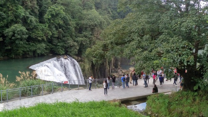
Glenarife was a bit of a back track for us on the road trip, but we had made the decision to go there second so we could have dinner at the restaurant inside the park. I plan to write a separate post about the food in Ireland, but I want to stress that planning meals on any vacation is really important, but especially on a road trip through the countryside. If you’re staying in a city, it can be easy to just head down any major street and walk into any restaurant that looks interesting. If you’re driving (or busing) around, then taking time to find where there are restaurants and WHEN THEY ARE OPEN can save you a lot of heartache and petrol station snack meals.
There is not a lot in the way of eateries on this particular stretch of the Irish coastline, so when I found the Laragh Lodge attached to a waterfall I was excited to get two birds with one parking lot, so to speak. We arrived at the Lodge around dinner time and were quite surprised to find the place very full. They had a wedding party in. Thankfully, there was a dining room off to the side for the general public, so we could still eat there. Because the day was drawing to a close, we decided to go on our waterfall walk before dinner. Same gray rainy day, still, but the raindrops had mostly stopped.
The trail leads a over a little creek which looked like it was made of Guinness, and up a slight hill. It’s a short walk from the parking lot to the falls. There are longer hikes around the enormous forest park for those who want to spend more time in the great outdoors. I personally was there for the waterfall and the food.
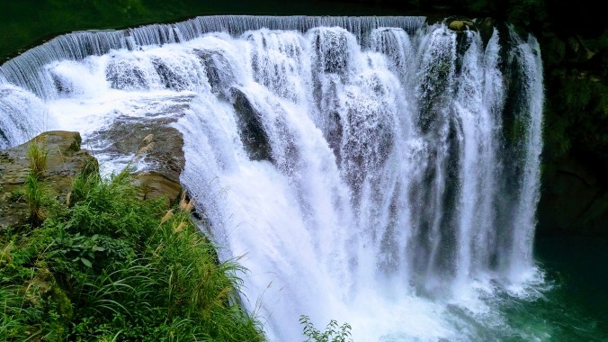
When you look up the Glenarife falls online or go to their website, you see pictures of a pretty little fall with usually 2-3 streams down the broad rock face. When I was there, it had been raining. A lot. No cute trickle of water, not even a stout fall, no — that day, the torrent could be used to power a whole hydroelectric station. Waterfalls release negative ions, which reduce depression and stimulate the brain and body. I know sounds kind of like pseudo-science bunk, but it’s been tested I swear! #waterfallinlove
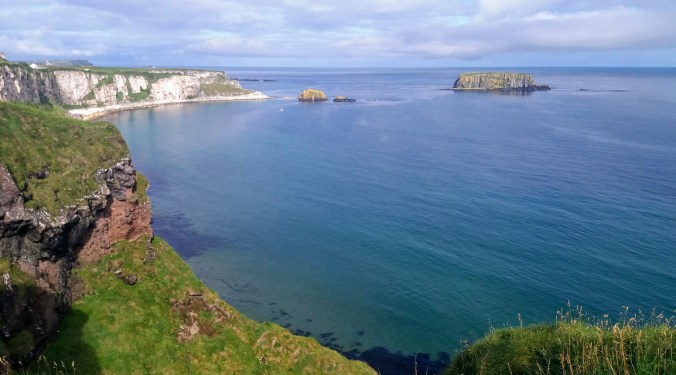
One Day on the Causeway Coast
The Giant’s Causeway may be the most popular thing on the north coast, but it’s far from the only one. We spent an entire day from dawn to dusk travelling the Causeway Road, visiting both it’s famous and less well known attractions. Technically the Coastal Route extends from Derry to Belfast and would therefore include my stops at Downhill Demesne, Bushmills, and Glenarm, but I am focusing on those parts most immediately surrounding the Giant’s Causeway itself.
Carrick a Rede
The rope bride of Carrick a Rede is often included on a tour of the Giant’s Causeway. After my initial research about things like parking and ticket times, we decided that the best way to do the bridge was very first thing in the morning. There is a parking lot near (1km) from the bridge access, but it’s small and fills up fast. Alternate parking is, of course, farther away. In addition, you must buy tickets in advance and reserve a ticket time. If you miss your window, then you don’t get to go. The bridge can only accommodate so many people at once, so the staff on site work hard to make sure everyone can have a good and safe experience. Weather is also important. As you may have seen in my Aran Islands post, the Irish weather on the coast is extremely fickle, and tourists aren’t able to enter the bridge if the weather makes conditions unsafe.
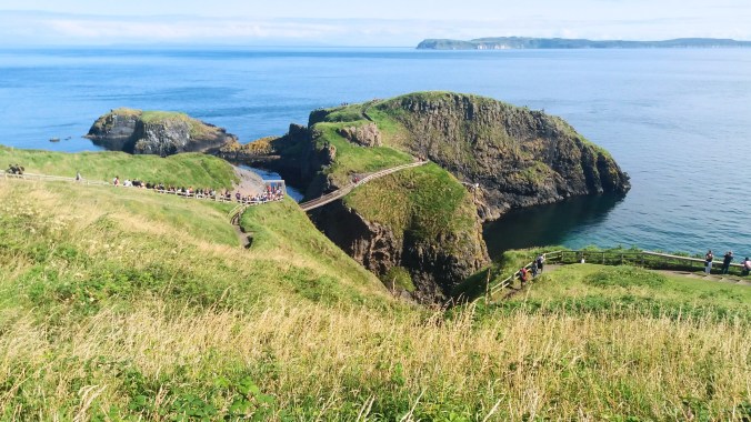
I was so happy that our weather was clear and blue. We showed up to the parking lot with plenty of time to walk. We had no trouble parking since we were in the first group. There was a little confusion at the ticket booth, a little bottle neck where we all clustered together waiting for them to let us in already! The other advantage to early morning tickets is that the tour buses almost never show up that early, so those of us who had made this effort really wanted to get the jump.
Finally, our e-tickets were scanned and we started the hike from the gate to the bridge. It’s not a hard hike, but there is an upward incline and many stairs. The great news is that the whole path walks along the cliffs and so you spend the hike up with the view to your left, and the hike down with the view to your right. Almost all the photos I took were on the way back down since we were in a hurry going up.
The bridge was built by salmon fishermen way back in the day because the little volcanic island had much better fishing than the mainland. The bridge today is purely a tourist attraction, but you can see the remains of the small fishing “village” on the island after you cross. There is a gate at the point where the trail meets the bridge manned by park staff who ensure that the safety measures are followed and to help people who may be nervous. The narrow (one person wide) rope and plank bridge is 100 ft above the sea and sways and wobbles as you walk on it. It is recommended that you and your travel buddies take pictures with the camera holder on solid ground while the other poses on the bridge. There’s no time for perfect Instagram poses, though, because while the staff will let you take a couple snaps, they urge everyone to keep going. Being so narrow, the bridge cannot accommodate cross traffic, and so a small group goes to the island, then when the bridge is clear a small group returns.

")
I could have spent the whole day on the beautiful little island. It was just such perfect weather and the grass was soft and fresh. I took a small infinity of photos of the sea and the sky, as well as the little flowers and volcanic rocks. It was only with great reluctance that I finally left to get to the next stops on the day’s itinerary.


I found a slightly alternate route back that took me up a little farther and gave some spectacular views down onto the path and island, and I positively delighted in the tiny flowers and busy bees along the cliff-side path on the way back down.
Dunseverick Castle & Falls
Along the Causeway Road are a large number of small sights. The rope bridge and the Giant’s Causeway are the main stops on every tourist bus tour, and in order to avoid those crowds, we decided to spend the prime tourism hours going to the smaller locales. The first one of these as we drove westward was Dunseverick Castle and Falls. What? Castle ruins and waterfalls? in one place? Twist my arm.
Dunseverick has been a seat of power in Ireland from the 400s! It was a ring fort for a bit, and supposedly visited by St. Patrick himself. Invaded by Vikings, and contested by clans, it was owned by the O’Cahan (anglicized as McCain or O’Kane) family until it was destroyed by CROMWELL (ugh, that guy again) in 1642. All that remains of the castle is the ruins of the gate lodge.
There’s a long walking trail that also runs alongside the cliffs which some people choose to hike, and you can access the ruins this way. I was not particularly interested in the route from parking spot to ruin, but the falls looked decently close, so I hopped a stile and headed off through the nettles to find a waterfall. It’s not as bad as it sounds. Stiles are meant to be hopped, they’re just ways to step over fences that humans can do but animals can’t. Also, nettles only hurt you if you grab them (which I didn’t) or fall on them (which I did, ouch).
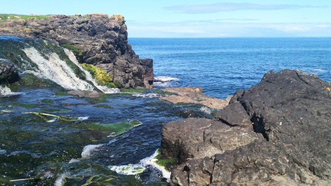
Nonetheless, the day persisted in being superb and I found the low and wide falls amid the dark brown and black volcanic rock. I don’t think I’ve ever seen falls along the seaside, so while they were a bit short, they made up for that by being unique.
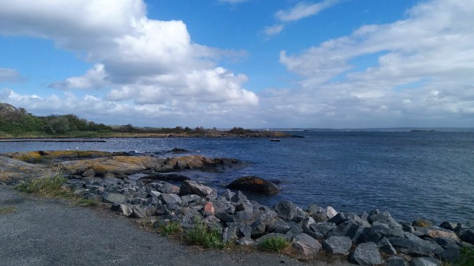
Bushfoot Beach
There are a few “beaches” along the coast as well, but not especially the kind you think of for sandcastles or bathing. We looked for Runkerry Beach, but I wasn’t able to figure out how to get the car there. Bushfoot Beach was adjacent to a golf club so we parked there and meandered down to have a look. It was small, and cute, with a nice bench to sit on and rest. Locals were out walking dogs along the path, and there was a river that came down and flowed into the sea right where we were. It wasn’t a highlight, but it was a beautiful and quiet place to have a little rest before the next stop.

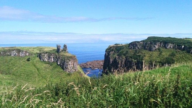
Dunluce Castle
Sound familiar? Yeah! This is the same Dunluce castle that dropped it’s kitchen and staff into the sea, prompting the McDonnells to move to Glenarm. The McDonnells are not actually Irish, they’re Scottish originally.

In case it wasn’t abundantly clear by now, I am an absolute sucker for ruins. Literally, if I could take a vacation that was made of waterfalls and ruins with a few good restaurants, I would be in heaven. I try to look up the history and learn things about the ruins I visit. They often have fascinating secrets or at least interesting stories. In the case of Dunluce, the kitchen staff falling into the sea might be the most interesting thing that ever happened to it until it was used by Led Zeplin as album art.
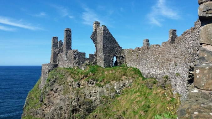
There were some very informative signs on site, showing artist renditions of what the house and grounds may have looked like when it was alive, and there’s a very dry Wikipedia article about the Earls and the invasions. I could recite that for you, but why? A far more amusing resource is this Belfast Telegraph article. Otherwise, please enjoy the photos!
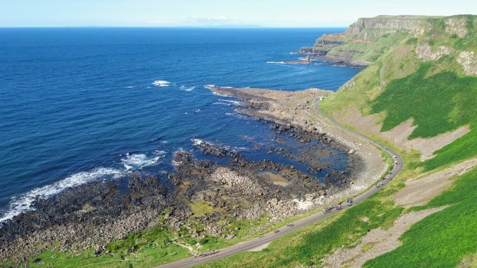
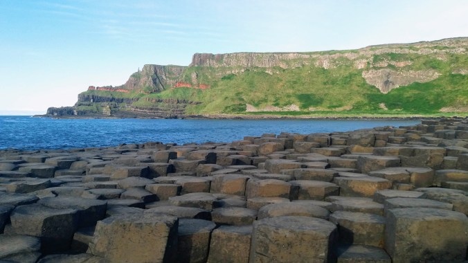
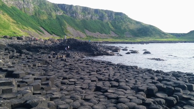
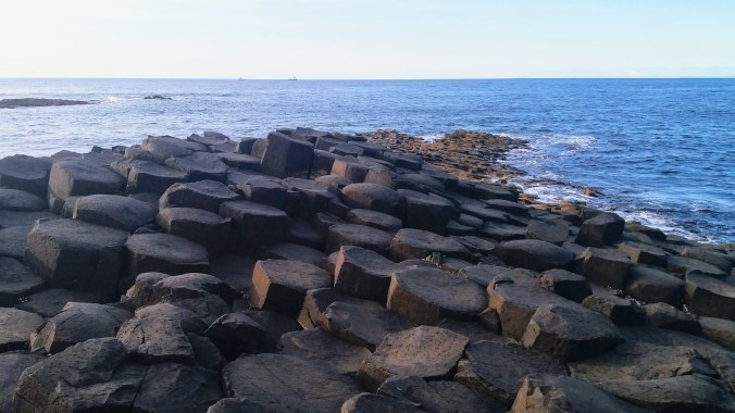
Giants Causeway
This is what we’re here for right? If you’ve come all the way to the tippy top of Northern Ireland you are here for THIS and everything else is pretty much frosting and sprinkles. Don’t get me wrong, everything else was wonderful, and I’m extremely grateful that I had the chance to drive myself around to the variety of stops. If you can’t rent a car or don’t want to drive on the left, there are tour buses that go to Carrick-a-Rede, Dunluce, and the Giant’s Causeway in a day, but after having done a driving tour and a bus tour (later) I have to say that driving in Ireland is (mostly) very easy and pleasant and having the freedom is well worth it.
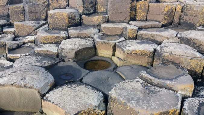
The Giant’s Causeway is a totally unique geographical formation of honeycomb-like stones reaching from the base of high grassy cliffs out into the sea. These formations are called basalt columns, and are made by lava cooling. As a not-geologist, I can’t really understand, let alone explain why some lava makes pumice, and some makes lava tubes, and some makes these cool hexagonal shapes, but I trust that there are geologists who can. The short and easy version is that something in the molecular makeup of basalt causes it to form cracks in these shapes when it cools rapidly. Probably why these formations are almost always found near water.

Although the Giant’s Causeway is by far the most famous, there are many other examples of basalt columns around the world, so you can still see them even if you don’t make it here. I was most fascinated to see there’s one here in Korea, on Jeju Island, that looks like a tiny version of the one in Ireland. It’s not a popular tourist attraction yet, so my tour didn’t go there when I visited Jeju several years ago. I’ll look for it if I ever go back.
Today we understand the science behind these fascinating formations, but when humans first came into the area, they incorporated the stones into the mythology of Ireland. I talked briefly about the pre-history mythology in my Two Irelands post. The beginning of Ireland was fraught with many races of monsters, giants, gods, and fairies, each one supplanted by the next. The 5th race was the Tuatha Dé Danann (from which almost all modern fairies seem to be descended), and the 6th and final were the humans. The stories of Finn McCool (Fionn mac Cumhaill) seem to be set toward the beginning of the humans arrival into Ireland since he fights with giants and at least one of the Tuatha Dé Danann.
The myth, like all myths, is tricky, and not every source agrees on the details. Most of us are more familiar with the Arthurian legends, and as anyone who has tried to sort out the details knows, it’s not possible. So, I’m presenting a vague and “best guess” version of Finn McCool here.

He was born into if not actual royalty, then the next best thing. His father’s clan was said to be descendants of the Fir Bolg (the 4th race) and his mother was recorded as a granddaughter of the Tuatha Dé Danann. Finn himself became the leader of the Fianna, a kind of warrior band, and had all kinds of fantastic feats attributed to him. You can’t go anywhere in Ireland without finding some piece of local Finn legend. According to the most popular stories, he (like Arthur) is not dead, but merely sleeping in a secret cave and will return in Ireland’s greatest hour of need.
When it comes to the Giant’s Causeway, there are still a few versions of the tale, but the most common involves a Giant named Benadonner. Benadonner was a fierce Scottish warrior and a giant (one of the races previously driven from Ireland). One day Finn challenged him to a fight, but the giant didn’t want to cross from Scotland and made excuses about the sea as an obstacle.
Finn then built a bridge between Ireland and Scotland. This is one of the closest points between Ireland and Scotland, only about 28 miles to the nearest Scottish peninsula. When the bridge was complete, Finn sent a message to Benadonner that he had no more excuses, so come along and fight me!
 However, when Finn saw Benadonner crossing, he realized the giant was much bigger than he previously thought. He fled the coast, retreating into his home. His wife Sadhbh (omg Gaelic, amirite?, that’s probably pronounced “Saive”, maybe?) heard what he’d done and quickly dressed her husband up as a baby.
When Benadonner came to find him, he saw the disguised Finn alone in the house and thought to himself, “If this is the infant, what must the father be like?”, and quickly fled back to Scotland, tearing up the bridge in his haste, leaving only the remnants at either end: The Giant’s Causeway in Ireland, and Fingal’s Cave on the Scottish Isle of Staffa, named for Finn himself. (Although the nearest point is only 28 miles from the Causeway in Ireland, Fingal’s Cave is 82.5 miles as the giant flees).
Whether you are drawn to the science or the more whimsical heroic tale, there’s no doubt that the natural beauty of the Causeway is breathtaking. We scheduled 4 hours for it and that was barely enough. It’s a hard choice to make as far as what to see in a single day. If I had it to do over, I might have scheduled one day for just the Causeway, and a second day for all the other stops. We planned to arrive around 3pm so that we would be walking in about the time that most of the tour buses were walking out.
I found some shuttle bus information online, but it turned out not to be as accurate as I’d hoped and in the end, we decided that paying for parking at the visitors center was going to be better for us convenience-wise than trying to take the shuttle bus from Bushmills, and honestly only slightly more expensive. If you happen to have a National Trust membership or possibly even a tourist pass, you can get steep discounts on things like the shuttles, the parking and the entry tickets (many are free included), and I also looked into buying that, but since only Northern Ireland is run by the UK National Trust, we just weren’t going to go to enough places to make pass worthwhile. If I were to plan a trip that included even one more day in the UK, I think it would have been.

The parking lot is enormous and the walkways funnel tourists to the Visitor’s Center. You don’t have to go there. The outdoor parts of the park are FREE (after you pay for parking or the shuttle bus) and the visitor’s center is like 13£. I opted to spend my time and money seeing the sights in person, but I can see if you perhaps had bad weather, the visitor’s center might be appealing.
Another travel blogger advised me to take the red trail from the Visitor’s Center to the Causeway. There is a main road (paved wide road) that goes very directly. People who are in a hurry may use this, and there is another shuttle bus that runs between the Causeway and the Visitor’s center which I think is very nice for those with limited walking ability. However, the red trail leads up along the cliff tops before descending to the sea, and it has some really stunning views. It’s much easier to walk it going down than going up, so starting on the red trail and then using the wide seaside road to return seemed the way to go.


The main trail starts by going through a tunnel near the visitor’s center, while the red trail starts before the tunnel and off to one side. There are signs. It is marked as a more demanding route, but that is only in comparison to the smooth wide paved main path. It’s about a mile (UK, back to imperial not metric!) and there are maybe 100 stairs going down. I thought we could take the shuttle bus back up, but that stops running when the visitor’s center closes at 4pm, so if you are mobility limited, make sure you plan your visit earlier in the day that I did.
The red trail is not for those afraid of heights. It goes along the edge and has some harrowing narrow paths and steep steps on the climb down. I thoroughly enjoyed the walk which included yet more stunning cliff-side views, a million tiny flowers and the little bugs that live in them (one of my favorite subject for photography), and a chance to see the organ pipes formation and the giant’s boot on the way down (something those who take the main path would have to climb up to see).


It was charming to see the tourists delighting in hopping from rock to rock like a childhood game of hopscotch. I climbed as far out to the edge as I could, marveling at the geometrical patterns and the tiny lichens and barnacles living there.


Finally, as dusk loomed, we headed back up the road, enjoying the tide pools and sunset over the water. There’s no doubt in my mind that the Giant’s Causeway is the jewel in the crown of Northern Ireland’s natural beauty and I’m grateful that I was able to experience it on such a beautiful day.


 After eating and stretching our legs, the buses moved on to Dutayeon. The area of Dutayeon is beyond the Civilian Control Line, was closed to civilians after the Korean War and was only recently reopened to the public in 2006. It’s still necessary for us to register ahead of time with the government in order to visit the area, and for some of our group to wear GPS tracking necklaces around while in the park. Of course I volunteered to wear one for our group. Are you kidding? The Dutayeon Park area also includes the warning: “Not all landmines have been found, so stay within the permitted areas.” It’s not your average hike in the woods.
 That being said, it is a beautiful area. The river that runs through it ends in a small but powerful waterfall that is the crown jewel of the park, visible across from the pond and from viewing platforms on both sides. There is a loop trail around the park, so it doesn’t matter which way you go from the pond. We headed right and passed by quite a large number of unexploded mine signs on our way toward an outdoor exhibit of mines used in the war,
  as well as other security measures and a mock explosion that demonstrated the sensitivity of the mines by blowing foam bits around in a ball while playing a low volume explosion sound whenever hikers came too close. There were also many happier decorations including party banners between trees, wooden deer and pigs, and a whole wall of paper prayers and wishes.
  After crossing the brigde, we followed more winding forest paths through beautiful red trees. We climbed up some stairs to get to a viewing platform just above the falls and then continued on further upriver. When it came time to cross again, there was no bridge, but instead a trail of stones that required us to hop across. Most stones were large enough to allow two people at a time, but not all. Some stones could be easily stepped between and others required jumping. Plus, everyone wanted to stop in midstream for a geourgous photo-op. The end result was a long and patient crossing while trying not to get bumped into the water by people crossing the other way. This was mostly acheivable, except for when the Ajuma needed to pass. These are the ladies who wait for no one and push everyone aside to pass. Behavior that is just rude and annoying on the subway suddenly becomes hazardous when trying to balance on river rocks. Oh, Korea.
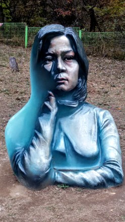 Back on the near bank, we followed the trail up to a gazebo/pagoda hybrid that overlooked the waterfall once more, before following a side trail up and over to a sculpure garden that included various works of outdoor art inspired by the war or the peace as well, as a missile and several tanks that were leftovers from the fighting. One of the most fascinating pieces was a painted sculpture that blended 2d and 3d art. The sculpture was the bust of a young woman, but only half of it was painted realistically, the other half had been painted blue. In addition, the depth was unrealisitc as well. The combination created an illusion of a different perspective of portrait from each angle as you walk around it. There was also a kitchy photo frame where we took a group shot, and a copse of giant eyeballs which was meant to show the sourse of all the tears shed for those lost. There were art pieces made from the objects of war, such as the barbed wire dandilion, and other shapes made from reforged metal. All in all, it was a surreal yet emotional tribute to the history and tragedy.
 From the park, we wended our way over to a small war memorial. Mostly we stopped here because it was necessary to file more paperwork for the Eulji Observatory. The memorial was very artistic and very sad. There were nine pillars representing the nine big battlefields in the area (Dolosan, Daeusan, Bloody Ridge, Baekseoksan Mountain, Punch Bowl, Gachilbong, Danjang Ridge, 949 Hill, and Christmas Hill), as well as statues of soldiers, displays of weapons and a whole room the floor of which was covered in shell casings from the war. Growing amid the barbed wire and destruction were small and beautiful flowers. There was a poem there ending in the stanza:
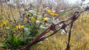 While reading these lines, I stood over the discarded shell casings, and under the helmets of dead soldiers, my camera filled with photos of beautiful flowers growing around the site. Although small and far less grand than the UN Memorial in Busan, the closeness of things these men had touched or died in amid the natural beauty of wildflowers and creeping red ivy brought the tragedy of war far closer to my heart than a cemetery or a statue ever could.
 I could see one winding dirt road, some tires stacked and filled with dirt or sand to create a barrier, and a lone watchtower surrounded by more barbed wire fencing. Beyond these decrepit signs of occupation, the land seemed as wild and untouched as though looking back in time to before humans even arrived. Coming from South Korea, where all the land is so thoroughly occupied that wildlife is all but vanished, it was a stunning contrast.
 Inside the observatory, there is an enclosed viewing platform that overlooks the North. A brave soldier who spoke some English decided to read an English presentation to our large group. He was very nervous, but it was a great gesture that he wanted to share information with us, so we filled the small auditorium and listened politiely while staring at the mist shrouded emptiness behind him. He told us about famous battle sites around the observatory including Stalin Hill, where the South lost some land that is now part of North Korea, a radio tower used to block signals traveling into the North, and a distant waterfall called Fairy Waterfall where beautiful North Korean women used to bathe nude to entice South Korean soldiers. He also indicated that North Koreans did use the area nearby for agriculture, although to my eyes it looked completely natural and I cannot imagine that the food they harvested there would be anything more than wild gathering.
 I stepped back outside, feeling disoriented from the whole experience, looking back and forth across the narrow fence from a high vantange point where I could easily see North and South at the same time. (hint, the South is on the right, the North is on the left) Large ravens swooped around the peak, effortlessly gliding between the two countries gripped in cold war, alighting on the Northern watchtower, then returning to our parking lot to scavenge for crumbs left by tourists.
 Our last stop for the DMZ day was the 4th Tunnel. This sounds fairly ominous, because it also implies there are at least 3 other tunnels, which there are. The North has tried on at least 4 occasions to literally tunnel into South Korea to get troops behind the border for a massive attack. Before heading over to the tunnel entrance, we scooted inside the nearby museum for a quick propaganda film. The film was in Korean, but had English subtitiles. They were long, small and hard to read over the video, as well as not being the most accurate gramatically, but I got the gist: North bad, South good, Threat onging. The idea that the Korean War is over is not something that really exists up near the border. To be honest, it doesn’t really exist in Korea at all, but most of the time Korean citizens can ignore their war with the North the same way Americans don’t let the 7 wars their country is involved in affect them on a daily basis. This film was a little startling however, because it didn’t even make an attempt at looking like an “unbiased documentary” and was more in a tone in keeping with propaganda material from the 1950s-60s during the cold war with Russia, or the modern Chinese government propaganda films. I’m not sure how old the film was, but it certainly felt out of time.
 After the film, we filed into a large round tunnel. The tunnel we were walking into was dug with a serious drill by the South Koreans in order to reach the less sophisticated North Korean tunnel. It was a long walk, less than 1km I’m sure, but the tunnel was dim and damp and nearly perfectly circular thanks to the diamond tipped drill the Koreans had used to make it. Hard hats were available at the front, but there were nowhere near enough to accomodate our group size, so we simply left them behind. Inside the tunnel was another no photos zone. Fortunately, the internet provides, so you can see some photos that other people (including authorized tour guides) have taken of the tunnel and equipment.
 Where the modern and sleek South Korean tunnel ended, there were clear toolmarks in the rock, concentric circles left by the drill. Intersecting our tunnel was a much smaller one, no more than 2 sqare meteres, and rough hewn, carved out with picks and dynamite. A small train awaited us, one seat behind the next as the tunnel was too narrow for two abreast. The seats were low and a transparent panel protected us from the threat of falling rocks above, but the sides remained open. We climbed in, feeling even more like boarding a ride in a theme park, expecting a trek through the rugged rock. After a mere 100 meters, the train came to a stop. We could see tool marks, and holes that had been prepared for the next round of dynamite. I forgot for a moment about the photo ban, but when I snapped a few, the soldiers only politely reminded me not to and I put my phone away again.
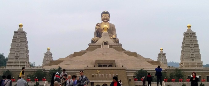
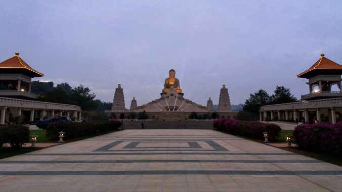
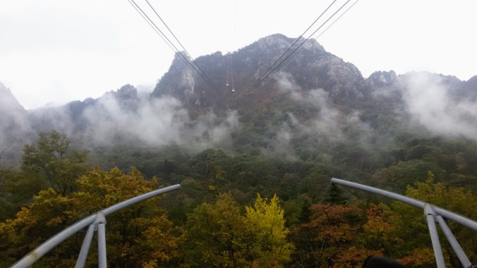
 The parking lot had more tour buses than Disney Land, and when we passed through the main entrance, we were greeted with a wide stone road lined with restaurants, cafes and other businesses catering to park-goers. There are several trails that can take over 12 hours, but we didn’t have that much time. After doing some research, my companions and I decided we would see the big Buddha, then walk the short (2 hr) waterfall trail, and finally take the cable car up to the highest peak for a look around.
 Our tickets in had, we followed the signs toward the temple, passing more and more restaurants, cafes and other buildings of unknown purpose. We rounded a corner and spotted the giant statue from a distance and made a bee line straight for it. The first thing that struck me was how similar it was to the
  Trying to keep ourselves on a decent timeline, we said our farewells to the stunning statue and set off in search of the trail-head to Biryong Falls. We soon joined a stream of Koreans dressed to the nines in their special hiking clothes. For many Koreans, espeically the older ones, outdoor activities are a serious glamour show. All the clothes are brightly colored and brand new looking. Meanwhile, my friends and I were dressed in jeans and hoodies because that’s usually how we walk in the woods at home.
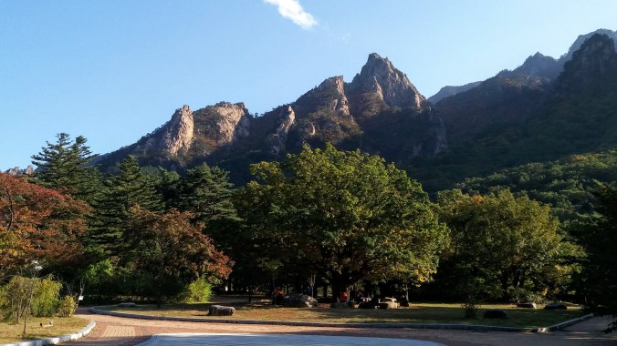
 The path involved some beautiful views of the surrounding mountains. Unlike the Busan mountains which are low and covered in a softening green layer of trees, the Seoraksan mountains burst from the treeline with jagged teeth of bare rock, and this day, the whole thing was wreathed in clouds and mist making it even more haunting. We took a wide bridge over a river and ambled joyfully along the forest path, stopping to admire the trees on a regular basis. The Koreans around us took some pictures, but only at designated picturesque spots. The rest of the time they were in a hurry to get moving. So much of a hurry that we were jostled, bumped and even shoved if we were deemed to not be going fast enough. It was like being in the subway… for several km. We tried to walk on the side of the path, or even just step OFF the path when the hordes of ajuma came barrelling down on us, but it didn’t always work.
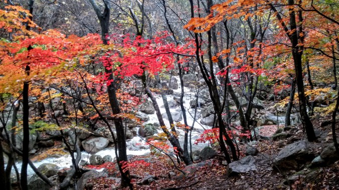
 As our path ascended beside the river, we were treated to the kind of views normally reserved for high class calendars and natural beauty screen savers. My computer randomly shows me stunning nature pics every time I log in, and I swear that one of them was actually from Seoraksan. We climbed up the slippery rocks, clinging to the railing and nearby trees until we reached two more bridges crossing the lower Yukdam Falls. The maps and pamphlets all say it’s just a 40 minute hike from the main entrance to these falls, but it had taken us close to 90, proving that 40 minutes was measured by ajuma walking standards rather than beautiful day in the woods standards. I understand that Biryong Falls was only a little farther up the mountain, but in order to make our cable car time, we had to turn back early.
 Our last adventure for the day was to take the cable car up to
  As we rose, the clouds soon fell below us, covering the view of the ground and the sea became visible off to one side. I had known Seoraksan was near the coast, but I had not realized how close to the ocean we actually were until that moment. The cable car stand at the top had more amenities, food and restrooms and coffee shops, but we swept past them and onto the viewing platform. I had read ahead of time that one could walk all the way to the tippy top from here and see an old castle, but after my experience on the waterfall path earlier, I was reticent to follow another stream of hundreds of hikers. We walked around the viewing area and found a distant waterfall, a long streak of white amid the green and brown of the mountains, visible even at this distance it must have been enormous up close.
 While searching for more and better angles to take majestic photos of the panorama around us, we stumbled upon a small path leading downward that
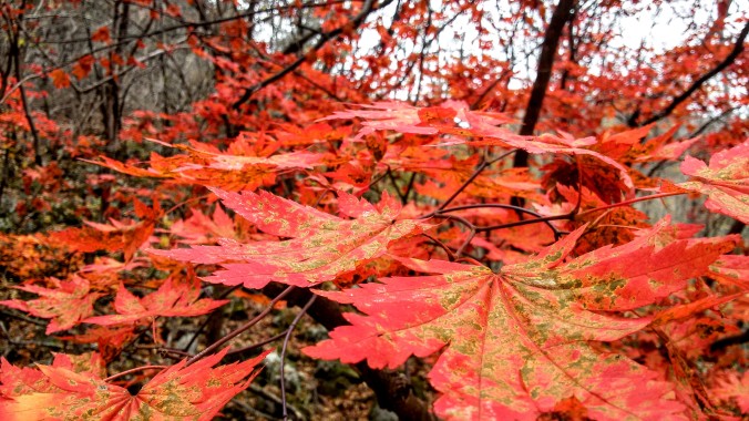

 They told me that’s the normal price for SPAM, it was just in gift boxes this time of year. This led to a whole side discussion about the cultural dissemination of
  The only real hitch was that we were taking the ferry from Mokpo instead of a plane. This meant a 4+ hour bus ride
  After we ate, we headed down to the water to frolic! The weather was gray, but warm. At first the water seemed chilly, but as I waded in further, I quickly adjusted. This beach was wide and shallow. We walked out for ages from the shore but the water didn’t even come to our hips. There were some Koreans playing in the water as well, but it seemed that only the Westerners wore swimsuits, everyone else went in the water in clothes. I’ve seen this at the beaches in Busan as well, and I’m still not sure what the cultural aversion to swimwear in the ocean is.


 The best view of the falls was obscured by the trees and vines growing around us and was from quite a great distance. I felt cheated. I think it may have been a beautiful waterfall, but the fact that we weren’t able to find out after so many stairs just felt like a bad con. And unlike waterfall 2 which was relatively easy to hop the fence and get closer to, this platform was high above the pool with a very steep and overgrown hillside, making navigation any closer dangerous and difficult.
 We went first to Chocolate Land because, well, chocolate. For some reason there was a giant statue of the Incredible Hulk outside. I don’t know what I was expecting, maybe giant chocolate sculptures or the world’s biggest M&M, possibly a history of chocolate exhibit, or a making of chocolate section. What the ‘museum’ turned out to be was a room (just one) sparsely populated with display cases showing off packaged candy from various countries. Even this could have been cool if they’d said something about it, why is the Arabian chocolate this way and the British chocolate this way… I tried the Kazakhstan chocolate my friend brought me from her visit home after all and was fascinated to learn the pride that the country takes in it’s national brand. But no, these cases just held boxes of chocolates. Some cases made an attempt at silly displays, like a taxidermied chicken with Cadbury eggs or a Nativity Scene made with chocolate coins, but it was incredibly grandma’s yardsale chincy.
 Half the room was filled with what seemed like Christmas themed facades that were, I assume, photo ops as well as a cafe where one could get some coffee, soft drinks, ice cream or candy and relax from the arduous walk through the musem. There was a chocolate making “class”, where for 12,000W you could pour some melted chocolate into molds. Outside there was a statue of Willy Wonka, but the Depp version, not the Wilder one. The final room was divided between more odd displays that seemed to have even less to do with chocolate than the ones before and the gift shop where one could redeem the 3000W entrance ticket toward the price of a sovenier. It turns out Jeju chocolate is quite tasty. They make it in fruit flavors that are unique to the island like Hallabang, Jeju Mandarin and Jeju cactus. The same boxes of chocolates are on sale all over, so it was basically like getting a 3000W discount on some chocolate I would have bought anyway for walking through a weird display room.
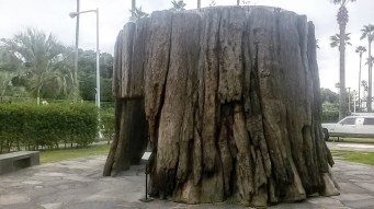 The trunk of a California redwood had been taken apart, transported and reassembled there so that the Koreans could see the stunning size of the redwood trees and experience walking inside the hollow trunk. It struck me that this was as close as most of them would ever get to a redwood and reminded me that museums aren’t just for history, but for the exchange of personal experiences. The most ridiculous thing there was the map of all the places in the world that Ripley had travelled. The map was covered in numbered blue dots with a key below. As we started to try to identify some of the places in the US, we realized that the geography was woefully inaccurate since Siam, Yugoslavia and Burma were all listed as being in the continental 48. Yugo-Slavia [sic] is in Florida.

 On our way past the beach restrooms we reached a point where the floor and walls seemed to move and I realized with horror that the whole path and retaining walls were COVERED in cockroaches. Horror movie levels of roaches. I am not afraid of most bugs. I can be startled by unexpected bug and I have a healthy respect for things that can hurt me, but there is something deeply lizard brain *ACK* about realizing that a good portion of your surrounding landscape is made of bugs. Fortunately, they didn’t want anything to do with us and moved clear of the path as we approached.


