Possibly the most anticipated blog from my New Zealand adventure has finally arrived. Hobbits! If you’re an avid Tolkein fiend, Jackson junkie or Frodo follower, this post is for you. Come with me into the magical lands of Middle Earth as brought to life in the Land of the Long White Cloud.
I Love Hobbits
 I remember having some picture books as a kid about Bilbo and Frodo Baggins. They were highly simplified versions of the stories in The Hobbit and The Lord of the Rings, but my mother loved those stories so much, she made sure I got started early. The books had read along audio cassettes that I could play in my own little cassette player (because digitial music didn’t exist yet, that’s why). I learned about Golum and the One Ring while I was learning to read. It’s safe to say that the stories of Middle Earth are embeded in my foundation.
 In high school, we used to use Dwarven runes to write secret notes and one of my friends even learned basic Elvish. In 1999 or 2000, my mother and I were walking out of some movie or other and saw a poster on the wall of the theater with Elijiah Wood and my mother immediately exclaimed, “It’s Frodo!” without even reading the text on the poster. It was indeed Frodo, and the poster was the first advertisement for Peter Jackson’s film rendition of the epic stories. Now the books have spawned a movie franchise, sharing Tolkien’s work with a whole new group of fans with 6 movies so far, and I hear more in the works. So, when I found out that the Hobbiton movie set was still alive and well in New Zealand, I of course fantasized about going there. And, when I found my travels taking me down under this year, I finally got my chance.
The Movie Set
The Hobbiton movie set is on private land. Jackson and his team chose from among several farms in NZ, finally selecting this one for the combination of the Party Tree (that giant tree Bilbo stands under at his 111th birthday party), and the natural hillside that enabled them to build Bag End in such a way that matched the physical description in the books. Jackson’s attention to the detail in the books was demanding, sometimes to an insane level, but it made the movies match the mental image so many readers and artists had carried for years after reading the tales. When Jackson asked permission to use the land, the farmer agreed with the proviso that the land be returned to exactly the way it was after filming. However, when Jackson returned to film the Hobbit movies, the farmer saw an opportunity, and this time demanded the set be built to last a minimum of 50 years so that tourists could come to visit after the filming was done.
Visiting Hobbiton is not an inexpensive proposition. It costs a little over 50$ US for the tour, but this goes into maintaining the amazing detail of the set, a full time staff of gardeners and repairpersons as well as guides and staff at the Green Dragon to brew ale and cook Hobbit food. It’s so much more than a movie set left behind, it’s a very nearly living village that makes one believe the Hobbits have just ducked out for a moment but will be right back. Also there is no way to view the Shire from the public roads, so if you want to see Hobbit holes, this is it.
The Tour Begins
 The tour is 2 hours long and starts at the visitors center where a massive car park surrounds a quaint gift shop and cafe. I was truly surprised at the number of cars in the lot when I arrived. The movie set is outside Matamata, and is quite remote. I had seen more sheep than people my whole drive over, and the nearest petrol station was more than 10 minutes away. When I turned into the car park, however, it was like a shopping mall on a Black Friday, I nearly didn’t find a parking spot. I did go on a Sunday, which may have accounted for the higher turn out, but there is no doubt that Hobbiton is a prime attraction. There is a fleet of green buses (the color of Bag End’s front door) emblazoned with the Hobbiton logo that drive visitors from the car park over to the movie set itself. On the way, the guide, Sam (our guide was named Sam, he swears it’s his real name and just a coincidence) told us that originally there had been no road into the farm this way. The New Zealand Army was contracted to come in and build the road so that all the set and filming equipment could be moved in. The farmer himself was under a non-disclosure agreement, so when one of his neighbors asked why the army was on his farm, all he could say was that they had been selected for a random road building exercise.
 Deep in the farm, past many more sheep and the now empty fields that once once housed the set construction, make up tents, cast trailers and craft services hall, we finally caught our first glimpse of the Shire, the water mill and the Inn of the Green Dragon on the lake. The excitement on the bus was palpable. Despite the huge numbers of tourists visiting each day, it seemed that very few were idle viewers and most were just as happy as was to be arriving at the real, physical, 3D version of Bilbo’s home town. We piled out of the bus to begin our walking portion of the tour next to some last minute bathrooms. I hadn’t had a chance to go at the visitor’s center so I decided to do so here. The outside looks like nothing so much as a rustic gardener’s shed, and I rather expected the inside to be about the same. Instead was surprised to encounter one of the cleanest and most well appointed restrooms I’ve ever seen outside a formal restaurant. So that’s one more thing the entrance fee is covering, well done.
Welcome to Hobbiton
 There is a sign at the entrance with old drawings of the Shire and an overgrowth of ivy. It welcomed us to Hobbiton and marks the real edge of where Earth becomes Middle Earth. As we continued on, we came through a narrow path with a high stone wall, the exact path that Gandalf uses to enter Hobbiton in his first appearance. Sam did a great job of pointing out all the details from the movie, as well as the books as we passed by, including many interesting stories of how and why the sets were built the way they were. The scene with Frodo and Gandalf on the cart uses forced perspective to make Elijia Wood seem Hobbit sized, so the path itself is very long and narrow to aid in the cinematic illusion.

 As we continued into the town, we encountered a few differently sized Hobbit holes. Each set was built based on whether it would be used as background for a “normal” sized actor playing a human or a Hobbit, or a smaller actor playing a Hobbit, or simply as background, all to create the forced perspective illusion that Hobbits and their homes are small in comparison with the visiting wizard.
After each explanation, we had time to wander around the immediate area and take pictures. Apparently the record for most pictures on one tour is over 3,000 and I’m happy to say I didn’t come anywhere near that. The detail on the sets was incredible. Tiny windows set into the mounds of earth with even tinier window dressings. Knickknacks, tools, tiny Hobbit sized clothing out on a line to dry in the sun, stacks of firewood, jars of honey, fish out to smoke, picnic tables set for second breakfast, the garden bursting with real produce, as though we were intruders in a life still lived.


We circled around the gardens, the frog pond, up the hill past the baker’s house, taking in the sweeping view of the Shire as we slowly ascended the Hill toward a familiar oak tree and the distant shadow of a green door. Most of the sets are closed off by gates, and Sam asked us to leave them shut, but there are a few without gates, where we could get much closer,  and even one with an open door to give us the chance to stand inside the traditional round portal. There is nothing inside, of course, the interior of the Hobbit holes were only filmed in the studio, but it makes for a unique and fun photo opportunity to place yourself in the role of a Hobbit. I didn’t have time on this trip, but when I get the chance to go back and stay in NZ longer, I’d love to dress up and get some photos in cosplay on this set. I’d also love to bring my niece and nephew before they get too big (Gnome, Squidgette, I’m talking to you) because so many of the Hobbit sized sets are perfect child size and include a lot of props that are not hidden behind gates. There was a Chinese family in our group and watching the little ones pose in front of the smallest Hobbit holes was a cuteness overload.
Up the Hill
The higher we got up the Hill, the more amazing the view became. I had to present my vacation to my students (learn English so you can do this too!) and I used a clip from the beginning of the Fellowship to show off the Shire before starting and it really made me appreciate just how very much like walking through the movie this place was.  Jackson’s attention to detail and commitment to the book was so intense that during the filming, he was unable to find plum trees in the right size to match a written description of Hobbit children sitting under plum trees, so instead he brought in pear and peach, but stripped them of their fruit and leaves to replace it with plum foliage, each leaf wired on by hand. The scene is only in the extended edition and only visible for about 2 seconds.
 Other examples of his eccentric dedication include the frog pond which had such an abundance of loud frogs that staff had to be employed to catch and move the frogs before filming each day because they were too loud to work around and managed to return each night. Finally, the famous oak tree above Bag End. New Zealand does not have oak trees, so the entire tree was built from steel and plaster, with real (although dead) tree branches for the outer boughs to imitate the movement of wood in wind. The leaves were made in Taiwan and shipped in, then stitched or wired onto the tree frame one by one. On the actual day of filming, the leaves had faded and were no longer the right color, so Jackson sent a team up the tree to paint them.
Bag End
When we finally reached that oh so familiar green door and the sign on the gate reminding us that there were to be no visitors except on party business, it was as though a piece of my childhood had stepped from the pages of a book and come to life in front of me.


The gate was closed, and our tour was not there on party business, so we remained just below the entryway, but we could still see through the partially opened door, the hallway decorations of Bilbo’s house. Because Bag End was filmed from both the outside looking in and the inside looking out, the entryway of Bilbo’s house needed to be correctly decorated, unlike the open door we’d been able to stand in for photo ops earlier in the tour. Additionally, while that opening door concealed a small space that only 2-3 people could stand in, the interior of Bag End can hold about 30 people and film equipment. The all-interior shots were filmed in a sound stage, but anything that showed Bilbo or Frodo framed against the open door with the Shire in the background had to be filmed there on site.
The Party Tree
 It was very hard to leave behind the house on the the Hill, but our next stop was the party tree and the green field where Bilbo’s 111th birthday party was held. However magestic the party tree looked from afar, it was even more imposing up close. It wasn’t so big as Tane Mahuta, but it was taller and still an impressive girth. Unlike the oak tree, the party tree is a real and living tree that was one of the main reasons this piece of land was selected to be the Shire. Within the meadow, there were party decorations and Hobbit games for people to try out including a maypole, some stilts, a game of ring-toss and some see-saws. Children and adults alike had fun testing out the various activities and admiring the detail of the design.
  Even the fence, which looked old and overgrown with lichen was artistically aged with plaster and paint, but indistinguishable even after we knew what to look for. Before we left the meadow, we stopped off at Samwise Gamgee’s own yellow round door where you could just imagine Rosy and the children playing in the garden.
Around the Lake
 From the party tree, we could see the Inn of the Green Dragon across the lake, but still needed to walk a fair way to come to it around the water. We passed yet more Hobbit holes, which is hardly a surprise because there are 44 total home fronts in the Shire (up from 39 for the Lord of the Rings), crossed a tiny bridge and came to a signpost dividing the path between Hobbiton and the Green Dragon. The path went into the forest as we left the town behind and I suddenly realized why so much of my time in New Zealand had reminded me so strongly of Middle Earth (you know, aside from the fact that nearly everything outdoors was filmed here). The forest path we were on, taking us around the lake, may or may not have been in any of the scenes, but it so clearly belonged there and just as clearly echoed so much of the landscape I’d been tromping through for the last week.
  There is something familiar yet otherworldly about the unique flora of New Zealand that must only seem familiar to the Kiwis themselves. For the rest of us, it is just different enough from what we are used to that it provides a sense of otherness, of the fantasitcal and created without being so foreign as to seem alien. The main context that I (and probably many of you) have become familiar with these plants unique qualities is in the films themselves, so it is no surprise that more than just the buildings here make me feel like I am walking in the footsteps of Bilbo himself.
The Inn of the Green Dragon
 As we emerge from the woods, we come to the stone bridge that leads us past the Mill and into the waiting arms of the Inn. This is possibly the only part of the tour that I have any complaints about and it is only because there is simply too much to do and see in the amount of time we are given here. The exterior is amazing enough, with the same level of detail and attention as every part of the set. There are places to pose, things to climb on, and shadowed alcoves to investigate, but inside is, if anything, even more intense. The indoor scenes of the Green Dragon were not filmed here (like all indoor scenes, they were done on a sound stage far away), but the Inn here at Matamata has been designed to replicate the indoor set in every way with the understandable exception of the small area that serves food and the modern plumbing. Once inside, visitors are greeted with a pint (yes, Pippin, it comes in pints) of locally brewed (for the brave and true) ale but there is much, much more.
  There are comfy armchairs by the fire, and artwork all over the walls. You can have a taste of Hobbit food if you fancy a light snack (I tried the steak and ale pie, it was yummy), you can try on Hobbit clothes, wield Gandalf’s staff, and explore room after room reading the local Hobbit bulletin board, peeking at the range of knickknacks on shelves, visiting the Inn’s cat (not in the movies, but, you know, cats), or just admiring the large wooden carving that gives the Inn it’s namesake. I tried my best to multi-task, to take it all in, but I felt like I’d only begun to scratch the surface when Sam gathered us up to continue our trek.
Farewell Shire
Walking past the pavilion (used for the Hobbit feast if you’re up for the price tag, and for private events like weddings and birthdays), we continued around the lake back toward the path we had entered from. The weather that afternoon was a brilliant blue sky dotted with fluffy white clouds that reflected so perfectly on the face of the still water along with the Mill, the trees and the few water front Hobbit holes. Although these photos aren’t movie accurate, they were still some of my favorite images of the day.


Our bus back may well have been a magic box that transported us from Middle Earth back to the land of car parks and gift shops. The gift shop itself is nothing special. About the only unique thing there is the beer and wine brewed for the movies and now for the tourists. There is a better selection of LOTR merch online, but that’s ok, this isn’t about the gift shop. Just expect that your souvenirs of Hobbiton will be your photos and your memories.
Despite it’s potential for crass commercialization, I enjoy movie magic. I’ve been to Universal Studios (still have to do the Harry Potter exhibit, but..) Hobbiton is different. It isn’t the costumes, actors or creatures that make Middle Earth come to life here, it’s the land itself. The majesty of the Party Tree, the sweeping vista visible from the front of Bag End that, as you stand there makes you feel that it is indeed a dangerous business, going out that front door, stepping onto that road because there really is no telling where it will take you…but you’re sure it will be one heck of a ride
I have so many wonderful photos and memories of this day. I sincerely hope you’ll take a moment to go and see the full album on Facebook. If you’re a Hobbit fan, it’s worth it. May the hair on your toes never fall out!
 the tattoos were done by cutting deep grooves in the skin and filling the wound with ink over and over so that it created a combination of ink and scar tissue for the design. Although the cheif joked that now they have a tattoo gun, he still pointed out that rarely do Maori get facial tattoos these days, and that the performers were all wearing make-up. Bear in mind the Maori tattoos may be the closest thing to a written language they developed and are just about as complex as any other ideographic language, so I’m only going to get the tip of the iceberg here.
 The basic legend: Mataora was a great chief who fell in love with and married a spirit from the underworld (Rarohenga) named Niwareka. One day Mataora struck her in a rage and she fled back to her father’s home in the underworld. Mataora felt remorse for his actions and decended to Rarohenga to find her. There he met her father instead who laughed at his painted face, wiping away the designs drawn there to show how useless they were. Mataora saw the permanent ta moka on his father-in-law’s face and asked him to mark his own face the same way. The pain was such that Mataora fell ill and his suffering softened Niwareka’s heart, so that when he recovered she agreed to return with him, and he promised never to hit her again as long as the markings on his face did not fade (so never). His father in law then granted him the knowledge of te moko and the Maori people have used it ever since.
 These four birds are the bat (go with it), the parrot, the owl and the kiwi. The bat represents knowledge. The head of the bat rests in the center of the foread and the wings spread out to either side. The parrot is situated along the nose, particularly the beak on either sideof the nose. The parrot is a talkative bird and this represents oratory skills and is very important in an oral culture. The owl sits on the chin (the only facial tattoo typically available to women) and represents protection. Finally the kiwi, envision it’s long beak open, rests on the lower cheeks, meeting the chin moko in a fluid design. The kiwi represents stewardship of the earth.
 The only real hand to hand weapon is the club, or patu. The patu can be made from wood, bone or stone and resembles a paddle being narrow at the edges although not sharp enough to be a true bladed weapon. In addition to being carried to war like the long weapons, the patu were also used by women who remained at the village when the men were away hunting or fighting so that they could defend themselves against any hostile raiders. Women were expected to be skilled enough with the patu to kill their attackers. The chief pointed out that due to the shape of the patu, if one hit the skull of an enemy with the edge and twisted, it would pop the top of the head right off, handily combining village defense and dinner. Yes, the Maori used to be cannibals, too, but don’t worry, he told us “now we have McDonald’s”.
 Pavlova was a dessert that by it’s name made me assume it was from some Slavic country, but the natives at my table told me firmly it was invented in New Zealand, no matter what lies the Australians are spreading. The pavlova is named after a Russian ballerina, which explains why I thought it seemed linguistically Slavic. It’s like a merenge but more complicated, having a crispy exterior and fluffy interior. It’s also supposed to be very tricky to make and prone to collapse if it’s cooled too quickly. It’s traditionally served with whipped cream and fresh fruit. I found it unique and delightful.
 How are
  I had noticed during some of the talks that there were some unfamiliar gender roles being described. For example, the chief had to be male, and it was possible for a man to take more than one wife, but women were the landholders. Pre-colonial Maori gender roles appear to have been definitive, but not derisive. That is to say, women had very clear roles and responsibilities, but they were not thought of as lesser than men’s roles, nor were women seen as belonging to men. A woman did not take her husband’s name nor relinquish her membership to her own family or tribe at marriage. Women were seen as the progenitors of life, responsible for childrearing and the home. The main difference is that these roles were not seen as lesser to men’s roles.
 The two main reasons modern Maori no longer wear traditional facial tattoos are the painful physical process and the social stigma. As I described earlier, the moko isn’t done with a needle, but by carving grooves into the skin and coloring the wound. This process is both painful and dangerous, and although could be replaced with a tattoo gun, there remains the second issue. Even as the moko mark them like each other, they also mark the Maori as separate and other from the British colonials. Due to years of colonial mistreatment and outdated ideas of “savages” that boil down to little more than racism, the presence of Maori tribal tattoos can still be cause for discrimination in modern day New Zealand.
 My guide said that he generally felt fine with other people getting Maori tattoos or wearing their art or jewelry as long as it was respected. These Maori tattoo artists won’t just put any old design you want on your skin, they will listen to your story and make something unique to you using the traditional Maori symbols and styles. So, while I suppose it is possible to print something off the internet and go to a non-Maori tattoo artist to replicate it, that doesn’t seem to be what’s going on in NZ and so it’s far less an issue of misappropriation and more a way of sharing and honoring. Later research revealed that the name for Maori style tattoos for non-Maori (Pakeha) is kirituhi and so most Maori don’t even see the kirituhi as being the same as the moko (even if it appears similar in design) because it lacks the spiritual and familial connections of a true ta moko.
 Before beginning the glowworm hunt, we passed by an outdoor village replica so that we could get a better look at the housing construction and village arrangement. This picture is in daylight, but when I was there it was night. It was a little hard to see in the dark, but the guide gave a good description of the house (as a body) and of the general village construction on a hillside that allowed for greater protection. Before we moved on, he reminded everyone not to shine the lights on the glowworms and also, to cup the lights in our hands and point them only at the ground, so we could see where we were walking without obstructing the night view. I think about 5% of the group listened to this, because most people were busily shining their lights all over the woods.
 They were a tribe of supernatural beings that lived deep in the forest, ate their food raw and shunned the light. They were described as having pale skin and red hair, and it is thought that the red-haired Maori are descendants of a union between Patupaiarehe and Maori women. The gloworms are sometimes said to be they eyes of the Patupaiarehe, since they can be seen only in the dark places. They were not spread evenly around New Zealand, but seem to be concentrated in certain areas including Rotorua where they are rumored to have come down from the mountains to drink from the pure waters of this spring. The spring puts out more than 24 million litres of water each day. The dark spots in the photos at the bottom of the pool are not rocks, it is the constant billowing of the seditment as it is churned by ever arising spring water from the bottom.
 we saw one of the native fish swimming around, but after the light was turned off and people started moving on, the freshwater eel resident of the spring came out. The second guide who was bringing up the rear tried to turn the light back on so I could see it better, but the light sadly drove it back into the rocks. However, having realized that I was more interested in the land than the majority of the tourists who were rushing ahead to get back to the halls, he stayed a little behind with me and started pointing out various interesting things around the bush.
 He told me about a kind of mud-skipper fish they have, and about some of the extinct land birds. He left his flashlight off and we found many more glowworms. I tried to show some of the other tourists on the walk, but they were too busy chatting to stop and look. The Mitai tribe has been watering their forest areas in order to boost the glow worm population. They aren’t seen above ground in great numbers because the atmosphere is often too dry, but a hydration program was having a profound effect on the local population and I saw probably hundreds throughout the walk all along the rock-sides sheltered by roots and leaves.
 You can’t go anywhere in the US without being on some tribe’s ancestral land, though. I learned about the tribes as we moved around the country. I learned their words in each new place because white settlers used the names the Natives gave to things long after the people were relegated to reservations, forced to wear western clothes, speak English and go to church. And in the few places where they are reclaiming their place, they are still only known for 2 things: casinos and tourist attractions. Casinos because crazy sovereign land rights make gambling legal on reservations. These buildings are decked out in the tackiest stereotypes of Native imagery with wooden carved Indians in giant feather headdresses adorning the entryways and sacred patterns hanging on the walls, using the images of their culture to draw in suckers. Only slightly less crass are the informational tourism spots where descendants of colonialists can come and see an authentic teepee or wigwam or rain dance. Sometimes they even sell sweat lodge experiences. And as much as I want to learn about the people and the culture, because that is maybe my greatest passion in this life, it feels cheap and tawdry whenever I see these displays outside of museums. This is not to say they shouldn’t live their own culture, but there is a difference between living your lifestyle and putting on a show.
 Maori Colonization: The explorer Kupe took a really big boat and ventured across the ocean, leaving his home in search of new land. It’s believed that colonization of NZ from Polynesia was deliberate and slow after this. It took several hundred years of ocean faring boats going back and forth bringing more and more Maori. In fact, the seven main tribes now identify by which boat (waka) their ancestors arrived on. For those who have been wondering about why I keep using other names to refer to NZ, Kupe named the land Aotearoa which roughly translates to “land of the long white cloud”. There are a few legends on why, but no consensus. The seven waka hourua (ocean going boats) and later the seven tribes, are called Tainui, Te Arawa, Matatua, Kurahaupo, Tokomaru, Aotea and Takitimu.
 The Treaty of Waitangi was basically an agreement the Maori signed with the British crown stating that New Zealand was under British sovereignty, but that the Chiefs and tribes would keep their own land (selling only to British settlers, no filthy French or Dutch here, please), and that the Maori would have
  Modern Maori: Are there arguments about land rights, water rights, fishing and hunting rights… and every other aspect of sovereignty? Of course, but it’s much more like an argument between people of (nearly) equal footing than in the US where we’re still ignoring the fact that our reservations don’t have safe drinking water or can’t fish their own streams/
  Armed with a better understanding of the history and a strong desire to learn more, I booked myself a table at the
  We were greeted at the entrance by a woman in traditional dress and (makeup) tattoo with the Maori greeting “Kia Ora” (
 Next we broke into smaller groups and bundled outside to see some of the village. Our group first visited the boat displayed by the front gate. Our guide explained to us about the word “waka” (boat) and the three most common types of waka for daily use (fishing and transporting goods), for war, and for long ocean journeys. She pointed out to us the way in which this particular waka was made using planks and that was how we could tell it was a replica and not a traditionally made waka. In fact it was the prop from the movie
 He taught them how to make the traditional war face which involves opening one’s eyes as wide as possible, sticking out the tongue toward the chin and doing an aggressive war cry. One of the men took this task quite seriously, doing his best to make an intimidating face and sound as he was shown, buy the other (and younger) was too cool for school and sadly sought audience attention by laughing at the process and doing a poor imitation of the war face, perhaps unwilling to look foolish, but in the end failing. We were asked to vote by applause and the man who went all out won by a landslide, which was nice, because I felt like he would at least take his duties as our chief for the night seriously and not treat it like some kind of opportunity for laughs.

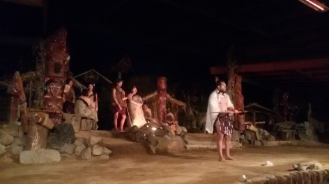 After the outdoor display, we headed into the performance hall. It was somewhere during this time that I started getting flashbacks to my childhood wild west/cowboys and Indians shows. The stage was set up to look like a Maori village, and once again, the guide was quite clear that it was a set and not real. The performance started with singing and dancing, then the cheif came out and gave a speech in Maori that of course none of us understood. While all the Maori performers were wearing traditional costumes, it struck me at once how different the cheif’s clothing was, especially the white fur cloak he wore. New Zealand has only one native land mammal, which is the bat, so where did this fur come from? It turns out that the Maori brought dogs, kuri, with them from Polynesia. The dogs were rare and their fur was prized as one of the elite materials for chieftain cloaks (along with fur seal skin), and because white was a common kuri coloring, I expect this was meant to represent a white kuri skin cloak and was quite prestigious indeed.
  After the sung entrance and the chief’s introductions, they introduced traditional Maori instruments of which there are two main kinds: melodic and percussive. Melodic instruments (rangi) include flutes made from wood or bone, gourd instruments that are blown into or filled with seeds and shaken, and trumpet instruments made from shells. These are considered the domain of the Sky Father but each group and specific instrument has it’s own god/goddess or spirit associated with it. Percussive instruments (drums, sticks, poi -the white flaxen balls on strings, and a type of disc on a cord) are considered the heartbeat of the Earth Mother.
 The weather was once more gray and drizzly, hot and humid, but with some sleep, breakfast and coffee behind us, we were enthusiastic to hit the road. I had done a bit of research on the crater that morning because of how the walk around the waterfalls turned out. I found some bloggers who claimed it was a 20 min walk if you just went straight up and about 40 minutes if you were a slow hiker. (it still took me about 45 that day). I felt better prepared for the hike ahead, but then we arrived late due to heavy traffic.


 According to the legend told at the temple, the first inhabitants of Jeju Island were three demi-gods who came to earth in a great flash of light and energy, and emerged from three holes in the ground. The temple is built on the site of these three holes, and no matter how much it rains, the holes never fill up with water. The demi-gods were named Go (
 After watching an informative film about the history and mythology of the shrine and the island, we wandered through the paths in the quiet woods. There are almost 1000 trees in Samseolhyeong. The other buildings included the museum where dioramas of the myth were displayed along with some of the original writings and ceremonial clothing from the earliest rituals performed starting in 1562. Additional alters, shrines, dormitories and halls were added over the years, but most were destroyed during Japanese occupation. Although the site of teh three holes is the same, the modern temple complex was rebuilt here in 1970. The walk through the trees was a refreshing break from the hot and humid weather. We admired many bangsatap (small stone towers built for luck) and more than a few dol hareubang (the stone grandfather statues that are the iconic image of Jeju).


 There were 3 special rooms along one wall of the second floor: the red clay room, the amythest room, and the gardenia room. The rooms had little doorways and were quiet and dark inside. Places where people sat on mats or lay with their heads on wooden blocks to relax or nap while enjoying the atmosphere. The red clay room was warm, but not quite sauna warm. The walls were red clay and it resembled the inside of a clay oven. I don’t think I could have stayed for long in the heat anyway, but we were driven out by one man’s snores before that. The gardenia room was a truly sauna level of hot. There was a stong floral (presumably gardenia) smell in the air, but the heat was too oppressive. My bare feet singed on the floor as I hopped to a reed mat for protection. There were many women sitting on the mats but the air was too hard for me to breath for long and I hopped back out without even sitting down.
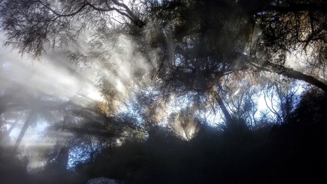
 There are signs at every natural hot spring that basically warn you of 2 things:getting burned and getting sick. Because these are natural springs, the temperatures are not regulated, and water that is hot enough to burn you sometimes rises up from the ground in the river and pool beds. You can be sitting in lovely water and suddenly a hotter current will come by. You can take a step to the left and land on a patch of mud that is scalding hot. However, these are not insurmountable problems if you exercise a little caution and common sense. Don’t dig down into the mud/sand at the bottom. It’s hotter below the surface. Feel before you put your weight down, test the bottom gently with a hand or toe before you put your weight down so you can move away quickly if it’s too hot. If you’re really worried about it, you can always wear water shoes. The other thing to bear in mind is that hot water breeds microbes. In the case of the Rotorua springs, there is a small concern of amoebic meningitis. That sounds scary, but it can’t infect you through your skin, only if it gets up your nose, so just keep your head out of the water and you’re in the clear. If all this sounds like too much work, that’s why the spas exist.
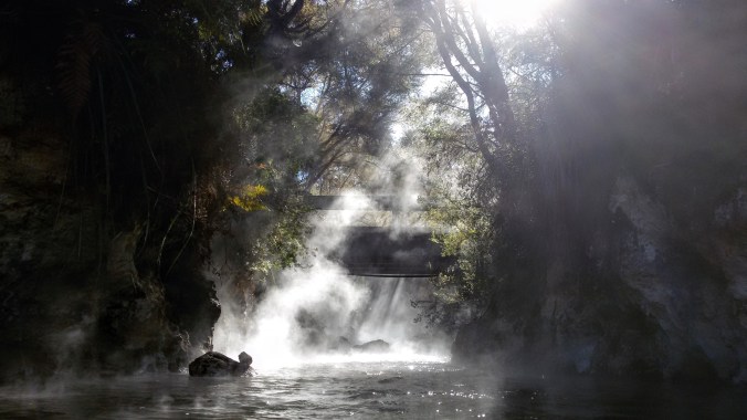
 There’s a beautiful and fairly large waterfall there and a pool that’s deep enough to sit in and have the water come up to a comfortable chest level. This spot is

 Not wanting to find my car locked up in the visitor’s spot, I
  The first thing you see is the top of the falls. These are quite lovely and worth a gander, but the water up here is too shallow to enjoy a soak, so head on down the trail a little further and you’ll find the pool. Despite it’s lack of popularity, it was indeed marked with another Dept of Conservation sign warning us about mud burns and amoebic meningitis, so the government was clearly aware of the fact that people were coming here and was just as clearly not prohibiting it. Ostensibly, this is a result of the Queen’s Chain policy of reserving 20m of land around bodies of water (and prohibiting the private ownership of said water).


 After eating and stretching our legs, the buses moved on to Dutayeon. The area of Dutayeon is beyond the Civilian Control Line, was closed to civilians after the Korean War and was only recently reopened to the public in 2006. It’s still necessary for us to register ahead of time with the government in order to visit the area, and for some of our group to wear GPS tracking necklaces around while in the park. Of course I volunteered to wear one for our group. Are you kidding? The Dutayeon Park area also includes the warning: “Not all landmines have been found, so stay within the permitted areas.” It’s not your average hike in the woods.
 That being said, it is a beautiful area. The river that runs through it ends in a small but powerful waterfall that is the crown jewel of the park, visible across from the pond and from viewing platforms on both sides. There is a loop trail around the park, so it doesn’t matter which way you go from the pond. We headed right and passed by quite a large number of unexploded mine signs on our way toward an outdoor exhibit of mines used in the war,
  as well as other security measures and a mock explosion that demonstrated the sensitivity of the mines by blowing foam bits around in a ball while playing a low volume explosion sound whenever hikers came too close. There were also many happier decorations including party banners between trees, wooden deer and pigs, and a whole wall of paper prayers and wishes.
  After crossing the brigde, we followed more winding forest paths through beautiful red trees. We climbed up some stairs to get to a viewing platform just above the falls and then continued on further upriver. When it came time to cross again, there was no bridge, but instead a trail of stones that required us to hop across. Most stones were large enough to allow two people at a time, but not all. Some stones could be easily stepped between and others required jumping. Plus, everyone wanted to stop in midstream for a geourgous photo-op. The end result was a long and patient crossing while trying not to get bumped into the water by people crossing the other way. This was mostly acheivable, except for when the Ajuma needed to pass. These are the ladies who wait for no one and push everyone aside to pass. Behavior that is just rude and annoying on the subway suddenly becomes hazardous when trying to balance on river rocks. Oh, Korea.
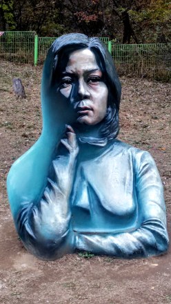 Back on the near bank, we followed the trail up to a gazebo/pagoda hybrid that overlooked the waterfall once more, before following a side trail up and over to a sculpure garden that included various works of outdoor art inspired by the war or the peace as well, as a missile and several tanks that were leftovers from the fighting. One of the most fascinating pieces was a painted sculpture that blended 2d and 3d art. The sculpture was the bust of a young woman, but only half of it was painted realistically, the other half had been painted blue. In addition, the depth was unrealisitc as well. The combination created an illusion of a different perspective of portrait from each angle as you walk around it. There was also a kitchy photo frame where we took a group shot, and a copse of giant eyeballs which was meant to show the sourse of all the tears shed for those lost. There were art pieces made from the objects of war, such as the barbed wire dandilion, and other shapes made from reforged metal. All in all, it was a surreal yet emotional tribute to the history and tragedy.
 From the park, we wended our way over to a small war memorial. Mostly we stopped here because it was necessary to file more paperwork for the Eulji Observatory. The memorial was very artistic and very sad. There were nine pillars representing the nine big battlefields in the area (Dolosan, Daeusan, Bloody Ridge, Baekseoksan Mountain, Punch Bowl, Gachilbong, Danjang Ridge, 949 Hill, and Christmas Hill), as well as statues of soldiers, displays of weapons and a whole room the floor of which was covered in shell casings from the war. Growing amid the barbed wire and destruction were small and beautiful flowers. There was a poem there ending in the stanza:
 While reading these lines, I stood over the discarded shell casings, and under the helmets of dead soldiers, my camera filled with photos of beautiful flowers growing around the site. Although small and far less grand than the UN Memorial in Busan, the closeness of things these men had touched or died in amid the natural beauty of wildflowers and creeping red ivy brought the tragedy of war far closer to my heart than a cemetery or a statue ever could.
 I could see one winding dirt road, some tires stacked and filled with dirt or sand to create a barrier, and a lone watchtower surrounded by more barbed wire fencing. Beyond these decrepit signs of occupation, the land seemed as wild and untouched as though looking back in time to before humans even arrived. Coming from South Korea, where all the land is so thoroughly occupied that wildlife is all but vanished, it was a stunning contrast.
 Inside the observatory, there is an enclosed viewing platform that overlooks the North. A brave soldier who spoke some English decided to read an English presentation to our large group. He was very nervous, but it was a great gesture that he wanted to share information with us, so we filled the small auditorium and listened politiely while staring at the mist shrouded emptiness behind him. He told us about famous battle sites around the observatory including Stalin Hill, where the South lost some land that is now part of North Korea, a radio tower used to block signals traveling into the North, and a distant waterfall called Fairy Waterfall where beautiful North Korean women used to bathe nude to entice South Korean soldiers. He also indicated that North Koreans did use the area nearby for agriculture, although to my eyes it looked completely natural and I cannot imagine that the food they harvested there would be anything more than wild gathering.
 I stepped back outside, feeling disoriented from the whole experience, looking back and forth across the narrow fence from a high vantange point where I could easily see North and South at the same time. (hint, the South is on the right, the North is on the left) Large ravens swooped around the peak, effortlessly gliding between the two countries gripped in cold war, alighting on the Northern watchtower, then returning to our parking lot to scavenge for crumbs left by tourists.
 Our last stop for the DMZ day was the 4th Tunnel. This sounds fairly ominous, because it also implies there are at least 3 other tunnels, which there are. The North has tried on at least 4 occasions to literally tunnel into South Korea to get troops behind the border for a massive attack. Before heading over to the tunnel entrance, we scooted inside the nearby museum for a quick propaganda film. The film was in Korean, but had English subtitiles. They were long, small and hard to read over the video, as well as not being the most accurate gramatically, but I got the gist: North bad, South good, Threat onging. The idea that the Korean War is over is not something that really exists up near the border. To be honest, it doesn’t really exist in Korea at all, but most of the time Korean citizens can ignore their war with the North the same way Americans don’t let the 7 wars their country is involved in affect them on a daily basis. This film was a little startling however, because it didn’t even make an attempt at looking like an “unbiased documentary” and was more in a tone in keeping with propaganda material from the 1950s-60s during the cold war with Russia, or the modern Chinese government propaganda films. I’m not sure how old the film was, but it certainly felt out of time.
 After the film, we filed into a large round tunnel. The tunnel we were walking into was dug with a serious drill by the South Koreans in order to reach the less sophisticated North Korean tunnel. It was a long walk, less than 1km I’m sure, but the tunnel was dim and damp and nearly perfectly circular thanks to the diamond tipped drill the Koreans had used to make it. Hard hats were available at the front, but there were nowhere near enough to accomodate our group size, so we simply left them behind. Inside the tunnel was another no photos zone. Fortunately, the internet provides, so you can see some photos that other people (including authorized tour guides) have taken of the tunnel and equipment.
 Where the modern and sleek South Korean tunnel ended, there were clear toolmarks in the rock, concentric circles left by the drill. Intersecting our tunnel was a much smaller one, no more than 2 sqare meteres, and rough hewn, carved out with picks and dynamite. A small train awaited us, one seat behind the next as the tunnel was too narrow for two abreast. The seats were low and a transparent panel protected us from the threat of falling rocks above, but the sides remained open. We climbed in, feeling even more like boarding a ride in a theme park, expecting a trek through the rugged rock. After a mere 100 meters, the train came to a stop. We could see tool marks, and holes that had been prepared for the next round of dynamite. I forgot for a moment about the photo ban, but when I snapped a few, the soldiers only politely reminded me not to and I put my phone away again.
 The parking lot had more tour buses than Disney Land, and when we passed through the main entrance, we were greeted with a wide stone road lined with restaurants, cafes and other businesses catering to park-goers. There are several trails that can take over 12 hours, but we didn’t have that much time. After doing some research, my companions and I decided we would see the big Buddha, then walk the short (2 hr) waterfall trail, and finally take the cable car up to the highest peak for a look around.
 Our tickets in had, we followed the signs toward the temple, passing more and more restaurants, cafes and other buildings of unknown purpose. We rounded a corner and spotted the giant statue from a distance and made a bee line straight for it. The first thing that struck me was how similar it was to the
  Trying to keep ourselves on a decent timeline, we said our farewells to the stunning statue and set off in search of the trail-head to Biryong Falls. We soon joined a stream of Koreans dressed to the nines in their special hiking clothes. For many Koreans, espeically the older ones, outdoor activities are a serious glamour show. All the clothes are brightly colored and brand new looking. Meanwhile, my friends and I were dressed in jeans and hoodies because that’s usually how we walk in the woods at home.
 The path involved some beautiful views of the surrounding mountains. Unlike the Busan mountains which are low and covered in a softening green layer of trees, the Seoraksan mountains burst from the treeline with jagged teeth of bare rock, and this day, the whole thing was wreathed in clouds and mist making it even more haunting. We took a wide bridge over a river and ambled joyfully along the forest path, stopping to admire the trees on a regular basis. The Koreans around us took some pictures, but only at designated picturesque spots. The rest of the time they were in a hurry to get moving. So much of a hurry that we were jostled, bumped and even shoved if we were deemed to not be going fast enough. It was like being in the subway… for several km. We tried to walk on the side of the path, or even just step OFF the path when the hordes of ajuma came barrelling down on us, but it didn’t always work.
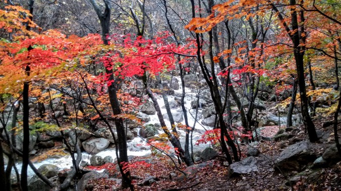
 As our path ascended beside the river, we were treated to the kind of views normally reserved for high class calendars and natural beauty screen savers. My computer randomly shows me stunning nature pics every time I log in, and I swear that one of them was actually from Seoraksan. We climbed up the slippery rocks, clinging to the railing and nearby trees until we reached two more bridges crossing the lower Yukdam Falls. The maps and pamphlets all say it’s just a 40 minute hike from the main entrance to these falls, but it had taken us close to 90, proving that 40 minutes was measured by ajuma walking standards rather than beautiful day in the woods standards. I understand that Biryong Falls was only a little farther up the mountain, but in order to make our cable car time, we had to turn back early.
 Our last adventure for the day was to take the cable car up to
  As we rose, the clouds soon fell below us, covering the view of the ground and the sea became visible off to one side. I had known Seoraksan was near the coast, but I had not realized how close to the ocean we actually were until that moment. The cable car stand at the top had more amenities, food and restrooms and coffee shops, but we swept past them and onto the viewing platform. I had read ahead of time that one could walk all the way to the tippy top from here and see an old castle, but after my experience on the waterfall path earlier, I was reticent to follow another stream of hundreds of hikers. We walked around the viewing area and found a distant waterfall, a long streak of white amid the green and brown of the mountains, visible even at this distance it must have been enormous up close.
 While searching for more and better angles to take majestic photos of the panorama around us, we stumbled upon a small path leading downward that
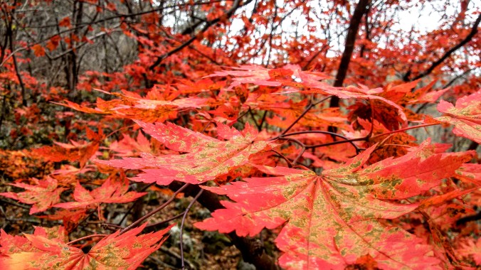


 And there’s the riots, which I am not happy to see. I don’t want violence to be an answer ever. Yeah, I know, the Trump supporters did it first, but now that they’ve won, they’d like it all to stop. People are like “oh you’re overreacting”, “oh you’re whiny cry babies” (nevermind that’s been pointed at us for caring about anything ever for decades, so it’s lost it’s oompf as an insult), but I voted in 2000 when this happened with Gore and I was not scared for my nation’s future (although, it turns out I should have been). I was mad when Kerry lost in 2004, too because that explitive promised to do recounts and bailed. And the Democrats didn’t take to the streets in protests and riots because voters who lost an election were capable of telling the difference between a guy we didn’t like the policies of, and a guy who we honestly believe will enable the ruination, incarceration, and deaths of humans we care for and respect.