If one is doing a road trip in Ireland, a couple of “must dos” are the Wild Atlantic Way, and the Ring of Kerry. The main point of the Ring of Kerry isn’t actually the many interesting stops along the way, but the beautiful views of the Atlantic Ocean from the road. However, since it is an extremely long drive, it’s nice to have places to stop and get out for a while. The main ring is the N70, which is a lovely wide (for Ireland) highway, but all the really good stuff is off the highway and down a series of narrow twisty side roads. Neither Valentia Island nor Skellig Ring are technically part of the Ring of Kerry, but it could be argued they are more interesting.
Car or Bus?
Driving in Ireland is not for the faint of heart, but if you are nervous, then you can also take a bus tour. The advantage of a bus tour is that you can spend the whole time looking out the window at the view. The disadvantage is that they only stop at a few very popular spots, and you have to contend with all the other tourists around your photos.
I personally enjoyed most of the drive, with the exception of a few moments of extremely heavy rain and one point where we managed to drive through a cloud. Low visibility on narrow steep roads is… challenging. Despite the white knuckle moments, I’m glad I drove myself because I got to pick and choose my own stops. There’s a nearly infinite list of things to see, and no way at all to do them in a single day drive of the Ring. The good news is, the Ring of Kerry is very affordable. I believe that some of the restoration houses and museums do charge a small fee to come inside, but as far as I know, all the outdoor attractions are free of charge.

This is the route I traveled according to my Google Maps history. We spent 10 hours on (and off) the Ring of Kerry, starting in Killorglin (a smaller town than Killarny, so the Airbnb was cheaper) and ending in Killarney (although we continued to drive on to Dingle that evening). For reference, most bus tours are 6-8 hours and start and end in Killarney, so you can imagine they move faster and see less.
The Challenge of Skellig Michael
Possibly the most popular place to visit on the peninsula is Skellig Michael. It is a phenomenally beautiful island with a wonderful wildlife preserve and interesting ruins of an old monastery. To preserve the environment, only a limited number of people are allowed to set foot on the island per day. If you are lucky enough to get a spot, the boats may be cancelled due to bad weather, even if the weather on land seems ok. They don’t call it the “wild” Atlantic for nothing.
 Even before 2017, it was a popular attraction that required lots of booking ahead. Then the Last Jedi came out, and suddenly the whole world knew about Skellig Michael as the beautiful and remote island where Rey finds the reclusive Jedi Master, Luke Skywalker. Those sweeping staircases and round stone huts weren’t inventions for the film, those are the actual ruins. Thanks to the Creative Commons I have photos to show you.
Reservations for boats that simply sail next to the island must be made up to a year in advance in the high season and I spoke to one couple that had been waiting for a spot on a boat that allowed people to walk on the island for more than 3 years.
As amazing as it would be to have the chance to go explore this beautiful place, I think that it would be something I’d have to plan a whole trip around, choosing a time of year that is just off enough to have availability without having your chances of bad weather above 80%, and then also being willing to stay nearby for several days/a week because when your boat does get cancelled, you are still around for the “make up” tour.
 There are so many beautiful small islands along the west coast of Ireland, and while none are the same as Skellig Michael, I think for most people, they are going to be just as enjoyable while being much more accessible and far less expensive. I myself visited the Blasket Islands (from Dingle), the Aran Islands (from Doolin), and a teeny little place called Inishbofin (from Galway). And if you just HAVE to have that Skywalker connection, the Blasket islands are actually in the film as well.
Finally, there is the Skellig Experience Center, which is on Valentia Island. I gather it is a warm, dry, indoor experience involving models, miniatures, and a video. I ended up skipping this as well because it was a recommended 45 minute visit, and we simply ran out of time for everything we hoped to do that day.
What I Actually Did on the Ring
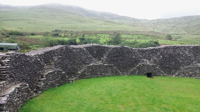
Cahergall Stone Fort
Stone forts or ring forts are ubiquitous in Ireland. There are more than 45,000 ring forts, some of earth, some of stone. Many are on private land, so you can’t necessarily just drive up to them, but lots and lots are open to the public and managed by a park service. This is not to say they are easy to find, or that they have any parking facilities, but if you are intrepid, you can do it.
There’s a very small parking area along a very narrow road with a little sign pointing to a sheep trail through a meadow, and if you follow this trail, avoiding the sheep poo, you will come up to the stunning sight of this majestic stone monument crowning the highest hill in the area. It’s not roped off, and you can freely touch, climb, enter and explore which is great. Because we were not with a tour group, we only ran into one or two others while at the fort, and it was easy to take lots of beautiful, if somewhat gray, photos.
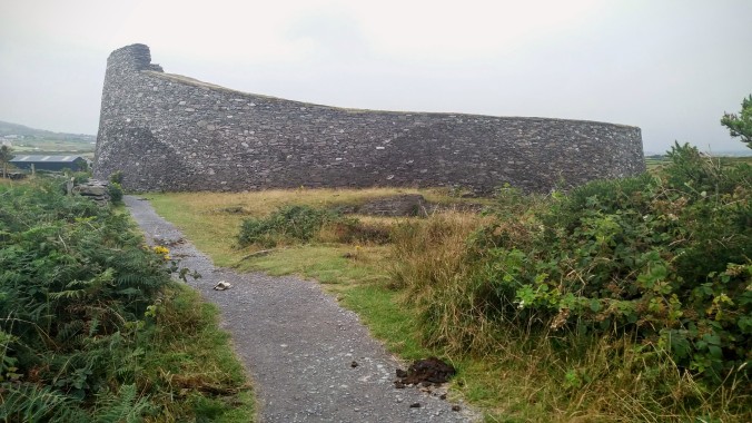
I feel like the term “fort” is a bit misleading. I originally thought that these were military installments placed on high hills for visibility and ease of defense. It turns out that these “forts” were probably more like farmsteads where people and livestock lived full time. The double ring looks like a good way to keep the animals safe in the outer ring, and the humans in the inner ring, with a ragged stairway up to a walking path. The strong stone walls would protect from weather, predatory animals, and rival clans. The livestock could be let to roam and graze in the day / good weather, and then gathered in, like a barn or paddock, as needed. The double ring with livestock would mean the inner circle of humans would be much warmer than the surrounding countryside.
Many historians think that the size of the ring indicates the owner’s social standing, which makes sense if you consider that richer families would have more livestock and more (living) children. The one at Cahergall is about 70 ft / 25m across. It also makes a lot more sense why there are 45,000 of them if you think of them as farms/homes rather than military forts.

Cahergall is one of the more famous rings because it has recently been restored and is quite beautiful. Some people think that the restoration is “cheating”, but it’s 1400 years old and was made by dry stacking flat stones (no mortar of any kind). The restoration makes it safe to climb and gives a good idea of what it would have looked like.

On our way back to the car, a farmer had come down to greet a tour bus with a young lamb in his arms. He wasn’t “charging” for the privilege of holding and petting this adorable soon-to-be-dinner, but everyone was giving him a Euro or two as a tip/thank you. We beat the tour bus by only a few minutes and figured that farmer would probably get 50 Euro or more from that bus alone for sheep petting… not a bad deal for him.
Valentia Tetrapod Trackway
There’s a trope in the story of evolution of the first “fish” crawling out of the sea and onto land. This is a very oversimplified version of how evolution works, but it’s a good story because it helps us visualize and understand the process. There was a period known as the Devonian between 350 and 370 million years ago where that process occurred and sea creatures gradually developed legs from fins and began to explore the food and safety options of damp land.
There are only 4 locations of earth where you can go and actually see the footprints of one of those animals and one of them is in Ireland along the Ring of Kerry.

I spent an inordinate amount of time in the Smithsonian Museum of Natural History as a kid and I even did a few amateur fossil hunts. I was delighted to find stones with the imprint of life that was millions of years old, and growing up did not reduce that delight. I recall finding fossilized seashells in the desert of Saudi Arabia, and being completely awed. So, when I found out that this level of rare fossil was available for the viewing, I had to go.
We had variable weather on the day of this drive, and were mostly lucky that the rain came down while we were driving and let up when we parked, but this stop was the one big exception. The tracks, like everything outside a city in Ireland, are not super easy to find, but Google Maps helped and there are also plenty of websites with landmark based directions. There’s a decent parking lot, but it is a bit of a walk down to the water from there. On the day I went, there was a documentary film crew on site, and they thought we were crew too because they just couldn’t imagine any tourists crazy enough to come down in that weather.
It was only a light drizzle when I started the walk, but turned into a serious downpour about half way down. I decided that since I was going to get just as wet walking back to the car as down to the shore, I might as well carry on. I got entirely soaked. Only my shoe covers kept my feet dry. Waterproof shoes or shoe covers are an absolute must in Ireland.
It’s a beautiful rocky shore, and the steps down are a little tricky in the rain, but not too bad. There are several informative signs with models of the tracks (so you know what to look for) and a bit of history about the site itself. 385 million years ago, Ireland was actually south of the Equator, and what is now a cold and rocky shore was a warm, silt laden river delta. In addition to the footprints, there are also fossilized ripples (below) made as the muddy silt dried in patterns and was covered over by layers of different soil. Both ripples and prints were compressed over millions of years as the landmass drifted north. Finally, the erosion of rain and sea revealed this layer of the strata.

The footprints are accompanied by a tail drag, since tetrapods were still heavy and low to the ground with long, broad tails for swimming. I think without the informative signs showing me what to look for, I (not a paleontologist) might have missed it entirely. Once you get all the way down to the shore, you know where to look because one area is roped off. Since this isn’t a restorable relic, we can’t walk on it or touch it lest we erode it away completely.
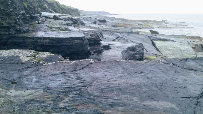
Before I went, I was thinking these footprints might be much larger because in my head, dinosaurs are huge. However, the Tetrapod was only about a meter long (3ft). For perspective, the average alligator is about 4x that size. The footprints are tiny little polka dots with a sidewinder looking divot between them (lower left quadrant of the photo above). They look not unlike a close up of a sewn edge with the thread removed. Once I got over the fact that I was soaking wet and that these were really small dinos, it was a very cool experience.
It’s not that you can’t see these kind of tracks in a museum, but there’s something… deep and connecting about seeing it where it happened, to know that this piece of rock was once thousands of miles away, and that your feet are there on the same ground that this ancient ancestor and key link in the evolution of life on land once walked.
Skellig Ring: St. Finian’s Bay & Skellig Chocolates
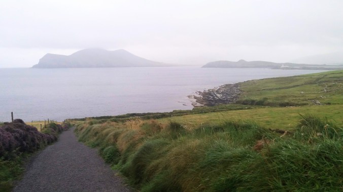
Skellig Ring is not part of the Ring of Kerry. It’s a little side loop down a peninsula and closer to the coast. While looking at the map, it seemed rather silly to go to Valentia and then backtrack to the official ring, so we kept hugging the coastline, which made for some lovely views.
I think we stopped at St. Finian’s because it was pretty and I needed a place to pull over and check the map. We were on our way to the Skellig Chocolate store and I was struggling to navigate the narrow roads, strange turn offs, and Google Maps all while driving a car on the “wrong” (to me) side of the road in the rain. It is a beautiful little beachfront, and I while it makes for a gloomy and picturesque photo op on the rainy afternoon I stopped there, I am sure it’s also stunning in nicer weather.

As for the Chocolate store, it’s a cute little chocolate shop, and they have lovely tastings where you can sample all the flavors before you decide which ones you want to buy. It was good, but not spectacular. I think I’m spoiled on chocolates. I’ll generally avoid the slave labor chocolate companies like Hershey’s, but I can order my fair trade online easy enough, so chocolate shops aren’t usually on my travel itinerary.
Theo’s Chocolates in Seattle is a stop I always recommend because they roast their own beans and actually make the chocolate from scratch (unlike most shops which buy chocolate then remelt it to add flavors and shapes). Plus, I love their factory tour which makes me feel like oompa loompas are hiding just around the corner. I also spent more than a glorious day in Brussels making my way around all the famous, historical, and newly excellent chocolate shops, chatting with makers and sampling a variety of confections, some of which were “meh” and others sent me over the moon with chocolate joy.
Skellig Chocolates are certainly better tasting than Hershey or Nestle. I enjoyed the flavors, but I wasn’t over the moon. Also, although they are making some confections on site, there is no tour or museum where you can learn about chocolate making. If you happen to be passing by, and have time, great, but you can buy the same chocolates in most Ireland gift shops or at the airport if you really want to try it and don’t fancy stopping your driving tour of natural/historical wonders for this tourist money trap.

If you want to see Valentia without driving the Skellig ring, I’d recommend taking the ferry (5 Euro/car one way) from Reenard Point and drive off the island via the bridge next to the Skellig Experience center, then follow R565 East back to the N70. I personally wish I’d been able to spend more time on Valentia to take in things like the Glanleam Gardens or the Fogher Cliffs, so even though I only wrote about the Tetrapod tracks, there’s a lot more to see there.
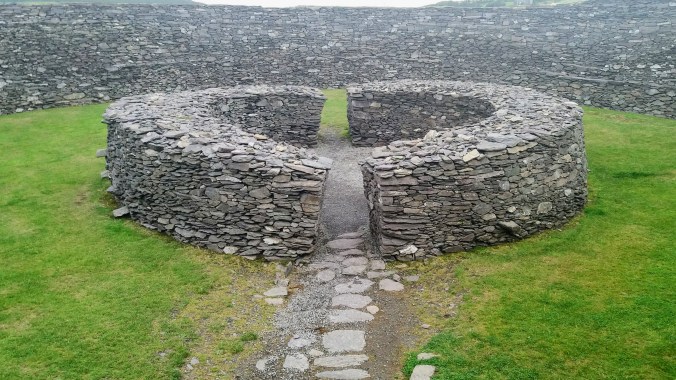
Staigue Fort
I like ruins. They are one of my favorite things to see. I like the stretching sense of history, and of being connected to other humans who lived and built things hundreds or thousands of years ago. I will almost never pass up the chance at a ruin. I wasn’t planning to see any stone rings after the Ring of Kerry, so I was happy to have an opportunity to compare two.


The Staigue Fort is considered one of (if not the) largest stone rings in Ireland. It is even larger than the Cahergall Fort, but it lacks the inner ring. It is older by about 300-500 years, and it hasn’t been restored as heavily, so it’s a little rougher around the edges. However, I did think that it was much easier to climb and walk on than Cahergall. The steps were wider and the path at the top was wide and smooth.
Unlike Cahergall which was on high ground, the Staigue Fort is surrounded by higher hills. It was deeply foggy when I was there, and so the whole place had that kind of ancient, spooky, mysterious vibe. I got to climb to the top and walk around.

I also learned what nettles look like for the first time from a local lady who was there showing her family around. I’m actually really glad I found out, because they sting if you grab them (or fall on them) so it’s nice to know what to avoid. I’ve read about nettles, stinging nettles, nettle tea and such in a wide variety of books, particularly by British authors, starting from childhood. I got so used to not knowing what they were, it never even occurred to me to look them up once Google was invented, and so now I know. Sadly, later on this trip, I was destined to find out how their sting feels… ow.

There is a sign at the gate stating that there is a 1 Euro charge, but there is no one to collect it, only a collection box, which was jammed by two coins in the slot when we were there. The local lady who told me about the nettles, also said it wasn’t really necessary to pay, but we left a coin anyway because I like to support the care and maintenance of historical relics.


The final bid to collect some coins is a small “waterfall” and “wishing well” which is really a cute little stream where coins can be thrown with a wish, so if you want to contribute in a more creative way than the collection box, you can always toss a coin in the water. If you’re lucky, you might even see some of the famous “rainbow sheep” up close!
Kenmare Stone Circle
Stone circles are quite distinct from stone forts. The most famous stone circle in the world is, of course, Stone Henge in England, but there are thousands of stone circles around the British Isles and northern Europe (France, Germany, etc). Stone circles are much older than stone ring forts, and most date from around 5000 years ago. They show no signs of habitation (leftover bits of pottery, food, or tools) and that has led most archaeologists to believe they serve a religious or ceremonial purpose. Lots of the stone circles are also aligned with the sunrise or sunset on the equinox or solstice, which lends some credence to their use as annual calendars.
Some archaeologists think anything they don’t understand must be about religion, but there are other possibilities, one of which is that these were meeting places for nomadic or semi nomadic groups to come, exchange goods and stories, perhaps even find spouses. The solar link of the stones would make it easy for everyone to agree on the right meeting day. Maybe there was some liturgical aspect to this as well, but think about how many of our modern holidays that focus on commerce, gift exchange, and extended family visits started out as and still involve at least a little bit of a religious day. (*cough*Christmas*cough)

Maybe if I went to a stone circle in the countryside on a dim gray misty day, it would feel more druidic or sacred, but the Kenmare Stone circle is in a town, and when we arrived, the town was also setting up for a fair and there were carnival tents and rides being built all around. I gave up trying to find real parking and just put the car down out of the way on the side of the road. There’s a small booth asking for a 2 Euro fee to view the stones, but like the other places, there is no attendant or enforcement, so donate or not as your conscience dictates.
I put the Kenmare circle on my list because stone circles are cool, and this one is considered quite large. It would have been silly to drive so close and not stop, but it was so strange to see this 4-5000 year old monument in such a cute suburban garden setting. The trees and lawn are well manicured, and there’s even an attempt at some flower beds nearby. Finally, there’s a wishing tree where people can write their wishes on paper and tie them to the tree branches.

As an American, it can be strange to me to see things that are more than 400 years old. When I do see ancient things, it is almost always in the context of a heritage site or museum or such, but there’s just so much old stuff in northern Europe that it isn’t at all uncommon to see it integrated into modern day life. I was watching a British interior design show, and one of the houses was 800 years old. It wasn’t some special historical site or museum, it was one of many homes in the village that was still being lived in by totally average people. The designers were looking at the wooden beams in the walls and roof and talking about when those beams were put in place 800 years ago and still in people’s living rooms. That kind of thing blows my mind.
The Kenmare Stone Circle is just that kind of thing: it’s a millenia old site that has been built into a modern public garden. It’s wild to see the contrast, and it’s amazing to contemplate the stretch of human civilization between the people who buried these enormous boulders and the people who mow the lawn and plant the peonies today. What it isn’t, is a magical connection to my druid ancestors, real or imagined, and that’s ok. Not every stone circle has to be a mystical experience.
Torc Waterfall
I love waterfalls. I will make a day of waterfall hunting, or drive miles out of my way to visit a waterfall. I honestly have to say, I could have skipped this one. The national park is gorgeous, and the waterfall itself is quite beautiful, since Ireland rains enough to keep the rivers full. However, this might be the single most popular stop in the whole south-west of the island. The car park was enormous, filled with tour buses and private drivers like myself. I’d seen almost no one all day (except at the chocolate store) and suddenly it was like the mall at Christmas. We had to circle the parking lot several times waiting for a spot to open up, and when we did finally find a place, and embarked on the short 5 minute walk to the falls, I was accosted by the noise of the crowd.

After a full day of quiet (often empty) Irish countryside and coast-way, it was a real shock. On top of that, it was our last stop of the day and we were tired, hungry, and in a hurry to get to our beds that were another 2+ hours away. I think on the whole, I would have been more satisfied to stop at one of the other viewpoints like Moll’s Gap or the Ladies View and skipped Torc. That, or spend more than one day on the ring so that Torc could be part of a greater exploration of the national park. There are several nice walking trails of different lengths and difficulty that would be a nice way to spend a day (or at least a half day), but sadly not a great way to end one. It should also be much more empty earlier in the day since all the tours end their day at the falls.
In Conclusion
The Ring of Kerry is a lot to do in a single day. If you are going to try to be crazy like me, carefully pick your stops in advance and plan rests since long periods of driving on those roads can be tiring. GPS and cell service gets spotty outside the towns, so load up your maps and make sure they’re available offline before you hit the road. Expect to have to turn around and ask directions, and know it will take you longer than Google says. Regardless of the expectations of speed limit, unless you are a very skilled/reckless driver, it is likely that the narrow curving roads will slow you down, and inevitably you will have to do some back up, drive around, wait for sheep.
Follow the advised direction (counterclockwise). I looked at the idea of going clockwise to avoid the tourists and I am SO GLAD I did not. There were several sections of the ring that would have been terrifying if not impossible to navigate going the “wrong” way. Everything is set up to make it easy for drivers following the route, and clever dicks online who advise you to go the other way are mad.
Take 2 or more days if you can. If I had it to do again, I’d still start from Killorglin, but I’d slow down, and stay in one of the small towns maybe 2/3 of the way through (Sneem or Kenmare) then spend the second day exploring the rest of the ring and the Killarney National Park. Live and learn.
