During my first two years in Korea, I took almost every opportunity to go to a festival or event. In large part, it was because as an EPIK teacher, I had very short holidays, so I spent my weekends seeking fun. Now that I have great big holidays, I find I’m saving my money for those long trips abroad. Plus, it is a bit repetitive to go to the same festivals and events each year. This year, my favorite tour group, Enjoy Korea, changed up the line-up on their fall foliage trip, so instead of going to the DMZ and Seoraksan, we would visit a famous penis park, a coastal railway, and Seoraksan- a mountain that’s quite large enough to visit twice and see totally different sights. I decided to sign up, and as luck would have it, some other ladies I know from around the country also signed up so we got to hang out together. Although it was a lot of riding in buses, the weather was everything we could have asked for, and I had a lovely time.
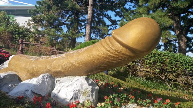
Haesingdang Penis Park (해신당 공원)
It is a constant source of curiosity and amusement among the foreigners that in such a conservative country as Korea there are multiple overtly sexual and outright pornographic sculpture parks. I visited the famous Love Land on Jeju Island a few years ago, and so I was curious to see the similarities and differences with that very modern invention and what was ostensibly a more historical park at Haesingdang.
The legend of Haesingdang has some inconsistencies, but basically there was a young maiden who’s fiancee (new husband? she’s supposed to be a virgin, though so they can’t have been married long) is a fisherman and through a series of unfortunate events he ends up leaving her on a large rock rather far from the shore (perhaps to harvest the edible seaweed?) while he takes the boat to fish, promising to return for her at the end of the day. However, a horrible storm arises and he is unable to fetch her and she drowns. The next day, there are no fish to be had, nor any the day after that. The people believed that the spirit of the drowned maiden was ruining the fishing.
Here’s where it gets extra confusing. There’s a group of three statues up on the hill overlooking the ocean that are supposed to be a part of the legend. The are very… um… priapic. I’m unclear as to whether they were masturbating into the sea, or simply showing this poor virgin girl what a good dick looks like. Many versions of the myth also state that it was a man urinating into the ocean that caused the spirit to be appeased and the fish to return, and anyone who knows the function of a prostate knows you can’t urinate when you’re .. um.

All the legends agree that it was the sight of a penis that made this virgin maiden relent and bring back the fish… I guess she was really horny? I don’t really know. Since then, the locals carved several wooden phalluses to put along the seashore and twice a year they have a religious festival to show big wooden penises to the maiden in the sea.
It’s really hard to get any hard data about this park or the statues in it. It’s likely that the myth and the rituals are hundreds of years old, but given the near total destruction of everything in that region during the Korean War, it is highly unlikely that those are genuine historical statues. More than likely they are modern reproductions and best guesses combined with truly modern art pieces like the golden penis on the stairs that was made in 2006, and a row of new statues that seems to be growing one penis a year down the path (the latest one was dated 2019).


Most of the museum looks like it was either made in the 70s or by someone aesthetically stuck there. The fishing village museum included a series of arrows leading nowhere past some large fake aquariums (plastic fish, no water) and a large diorama of a historical fishing village, plus some interactive video games and “fishing” toys.


There are plenty of photo ops where you can sit on a giant penis, or sit on a bench and look like a large erect penis and hanging balls are sprouting from between your legs. There’s a small temple dedicated to the maiden who drowned in the legend. And there’s about 50 or so wooden carvings of exaggerated penis shapes, or people with penises for heads, or penis totem poles. A star attraction is the 12 zodiac animals in penis pillars.


Aside from the overwhelming collection of dick, there is a stunning view of the sea from the top of the stairs which is in my opinion, one of the best parts of the whole park. You can actually see the rock from the legend in this photo. There’s a statue of the maiden on the rock you can see with binoculars.

Normally conservative and reserved Koreans take these kind of parks as a place to cut loose. Although no one did anything inappropriate like public exposure, there’s plenty of lewd gestures and old ladies laughing while their husbands look a bit uncomfortable. It’s not all bad for the guys, though, they get to pose next to unrealistic dicks and dream.
Yonghwa Coastal Rail Bike (삼척 해양레일바이크)
Also known as Samcheok Costal Rail Bike, it’s the same thing because there is only one rail bike in all of Korea.
“the one and only coastal rail bike in Korea and it runs on 5.4km-long double tracks through beautiful rocks and special type of pine trees called Gomsol (Bear Pine)”
I love the coast. Sandy beaches, rocky shores, sweeping cliffs, I don’t care I love it all. So when I heard this trip was going to include a leisurely hour long rail bike up the coast, I was pretty stoked. Now, I won’t say that this wasn’t hilarious fun, but if you’re expecting an hour of beautiful ocean views you will be disappointed.
A rail bike is basically a little car that is mounted on rail tracks and powered by pedaling. Thankfully, these cars had real seats and we were not mounted on bicycle style seating. Myself and the other short person had a very hard time both sitting and reaching the pedals, but with 4 people working on it, and some motorized assistance, the trip is not especially exerting.

The beach that we left from (Yonghwa) is quite pretty, but it is dominated by the rail bike station, and by the time we pedaled out of the building we only had a few moments of beach before we were leaving it behind. The beautiful view of the sweeping coastline is also partially obscured by those special pine trees and a fence. I had hopes that with the better part of an hour still to go, we would get more sea views, but the next part of the ride took us into a tunnel.
There was some distinctly Korean attempt to make the tunnels more interesting by adding colored lights and some neon underwater scenes, all set to strange 80s music in English. I think it would have been ok for a short tunnel, but it soon became droning and repetitive. My peaceful, sunny, seaside bike ride had turned into some hellscape of neon, concrete and bad club music. I didn’t even think about taking video at the time, so I’m borrowing my friend’s which is unforgivably shot vertical… sorry! I did at least replace the horrible 80s music with something less aggressive.
I know there’s probably no way we could have stayed outside in the mountainous terrain, but I feel like there is much more they could have done to make the tunnel more enjoyable. I was so relieved when it ended… only to have us go into a second tunnel! In the end, I’d say we spent at least 1/3 of the “coastal” ride underground.
Another 1/3 was spent outside with little to no view of the sea. We saw some cute pensions (a kind of Korean hotel), and a few resort attractions, and even a large sculpture of a battleship covered in some found art objects (I was moving to fast for a decent pic). The woods were randomly dotted with the leftover remains of the summer glamping (glam+camping) season, a few heavy machines, and a LOT of debris.

I know we had like 3 typhoons in three weeks and the coast did get a bit messed up, but it really seemed like zero effort had been made to collect the rubbish. There was a brief stop at a little “rest area” after the tunnels and the beach there was pretty and clean, but we had only a few minutes to enjoy it before we were rushed back to the rail bikes and sent on our way.

Although you and your group pedal yourselves, there’s not any wiggle room to slow down to see nice things or speed up to get past boring things because it seemed like 50 cars were on the tracks at the same time and although we’d been told to keep 10m between cars, it was often closer to 2. On the plus side, when we passed a group coming the other way, it was a lot of fun because they were excited to see a large group of foreigners and we got lots of greetings, big smiles, and high fives in passing.
Overall, I’d say it’s a fun but silly way to spend an hour, and not a calm bike by the sea. As long as you go into it knowing what you’ll get, it’s worth it.
Seorak Mountain and the Fall Foliage
Also known as Seoraksan, san simply means “mountain”, Seorak is one of the premier places in Korea to take in the fall foliage. It’s pretty far north, and close enough to the sea that you can see the ocean from the peak on a clear day. Plus, it’s elevated. This means that the conditions for beautiful leaf colors are really promising. It’s a little like driving up to Connecticut for Americans.
I went once three years ago and had a gray drizzly day which made the leaf colors really pop, but made the sweeping views pretty much a misty, uh, mystery… I also struggled a lot with the ajuma and ajoshi (Korean’s of a certain age) who all showed up in their special hiking clothes and walking sticks and charged up the path like it was a race to the top. I personally wanted to meander and enjoy the trees, take some pictures, admire the little details. They wanted to walk. Quickly. I was elbowed so frequently that it made it almost impossible to enjoy anything, let alone obtain any sense of serenity. I was almost knocked off the mountain (down a steep ravine) and when I slipped and fell on some wet rocks, people just shoved past me instead of giving me room to stand up or heaven forbid, helping. I did not want a repeat of this experience this year.
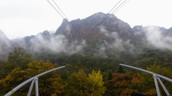
I am spoiled by the PNW mountain hikes which are quiet and often very private. I love forest bathing in Japan, and the peaceful mountainside temples. There is a temple at Seoraksan, but it’s a bit tricky to find. On my first visit, I managed to get a ticket to ride the cable car up and from the crowded platform, I followed a small trail with signs I recognized from the Chinese characters up and around to a small temple. There was no one else around, and I finally got some of the peace and serenity I was looking for. I was very much looking forward to visiting that place again.
This year, we had amazing weather. The sun was shining, the sky was blue, and it was just warm enough not to need a jacket but not hot enough to make us sweat. Upon arrival, we charged straight for the cable car ticket office only to find that everything was sold out until 3pm. Our bus was leaving at 4, and we couldn’t reasonably expect to get up and get back unless we rushed, which was counterproductive to my reason for going -eg to relax and meditate in that beautiful temple. I suppose we could have tried to race up for the chance to see the clear weather view, but neither my friend nor I were particularly interested in stress or speed that day.

I think that the park is gorgeous in any weather, but I’m glad I got to see it in the sun. I’d like the chance to hike it one day, but clearly the fall foliage isn’t the right time for me. It makes me think of the mountains I climbed in China, Tai Shan and Hua Shan. There were certainly other people climbing those days, and I was inevitably the slowest, but the Chinese were so much more relaxed about going around me, some liked to stop for a chat or a photo, but even those in a hurry didn’t run me down. It’s been a recurring issue for me in Korea that I feel like the frog in Frogger any time I’m anywhere crowded. I really don’t think it’s only crowds as other large cities, even mega cities like Beijing and Tokyo do not have these problems. It can make it a struggle to go to an event here knowing that being shoved around all day will definitely be part of it.
My goal for this trip was to try and find the part of the park that wasn’t going to make me play elbow dodge-em. We decided to stick to the less popular paths that wandered the foot of the mountains and just to enjoy ourselves and take a million photos. It was lovely. There were still a lot of people on the “boring” trails, but with only one or two hiking-gear clad racing groups it was easy to step aside and let them by. The rest of the people on our path seemed to share my idea that it was a lovely day for a stroll. Plus the walkways were smooth and wide, so there was plenty of space to go around / step aside and no risk of being knocked off a steep slope!

I got to spend a long time with the giant Buddha and even go to the small temple beneath it which had not been open the first time I visited. It wasn’t quite the same as my mountain peak temple, but it was nice to soak in the beautiful chanting and just still my breath and mind for a while. There was a monk inside performing a ceremony. It seemed like visitors could donate to the temple to have a prayer recited for them. I hadn’t realized it while I was above ground, but the chanting we were hearing all around the statue wasn’t a recording. It was the monk below chanting live. If you’ve never had a chance to hear a Korean Buddhist chanting, here’s a sample:
Most of the colors were higher up the mountains, we could see them from where we were, but still declined to hike up. Instead, I scampered off the path after the lone red tree or orange branch and ended up with a lot of close up photos. The effect of the sunlight streaming through the colored leaves was so stunning that I really didn’t mind that being my primary subject.
We came upon a clearing near the river about the time we were ready for a break. I sat down on the rocks overlooking a beautiful little valley view and just enjoyed life for a while, the trees made a perfect picture frame for the mountains beyond. When I had a bit of energy back, we climbed a little down to into the river bed. My friend actually went out on a huge rock in the middle of the river for photos, but I settled with a rock that was a bit closer to shore.

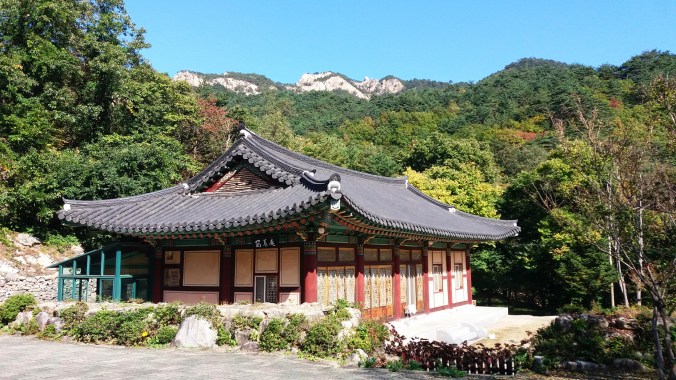
Next we explored the large (aka main) temple in the park. It had beautiful carvings of flowers on the buildings and bright blue ceramic tiles on the roofs. I think that my best overall landscape photo of the day came from a small grassy knoll just behind the temple compound. Bonus, I got to refill my water cup at the sacred mineral spring! Along the way, I also found several balanced rock towers left by previous tourists, any number of glittering spiderwebs, a few really beautiful spiders that hadn’t given up for the fall yet (they hibernate in the cold, I think because I never see them), and even a stray mushroom patch.

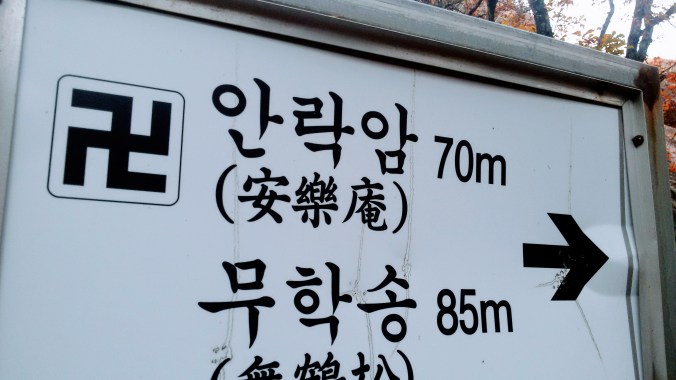
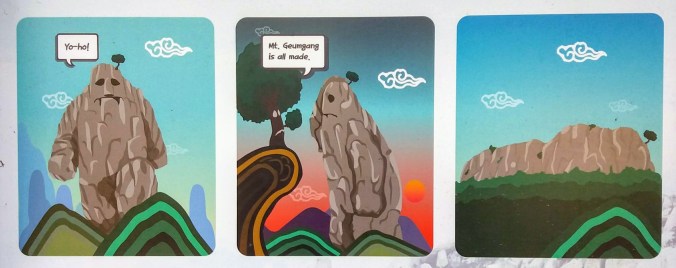
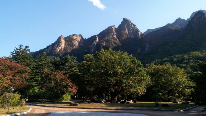
We walked a short way past the main temple toward the base of another arduous uphill hike. We had no intention of going up, but we thought it might be nice to walk along and see what else was on ground level. I’m glad I did because we found the Legend of Ulsanbawi Rock. The hike we were avoiding would have taken us up to this famous rock, but we could see it pretty well from the ground that day.
According to the legend, a looooong time ago, the gods ordered all of the rocks to gather together to create the 12,000 peaks of Geumgangsan. Also sometimes spelled “Kumgang”, this is the most famous mountain in North Korea. Obviously the myth predates the 38th parallel. However, it’s only about 50km (30 miles) north of Seoraksan. Ulsanbawi was a very large and heavy rock, travelling from Ulsan, about 350km (217 miles) from Kumgang. He had only got as far as Seoraksan when it became dark and he laid down to have a rest. The next day when he awoke, he learned that Kumgang was all finished being made, and he was no longer needed there. However, he was too ashamed and embarrassed to return home to Ulsan, so he curled up on Seoraksan and has remained there until this day.
On the way back from our low ground view point of Ulsanbawi, we found yet another small temple, and passed a number of beautiful bridges criss-crossing the rivers. Lunch was only slightly challenging as we looked for a keto-option. I had hoped for the famous seafood pajeon for myself, but there was such a large back order at the restaurant, they said it would take over 30 minutes. I ate bibimbap instead, and it was still delicious sitting on the patio staring out at the mountains as a backdrop.
We rushed to grab more last minute photos of the park entrance we had raced by on our arrival (hoping to get those cable car tickets), and made it back to our tour buses with about 1 minute to spare. It wasn’t an action packed adventure, but it was almost everything I could have hoped for. I was still a little sad about the cable car situation, but I saw so many other beautiful things, and I didn’t get run into by a speeding ajuma even once.


 With only one more wrong turn (I foolishly went into the building labeled Foreigner’s Fishing thinking I might pick up my rental rod there, but nope) I at last had my tiny blue fishing rod and my own hole in the ice. As I stood there working out the fishing technique by watching others, I began to relax and look around. I might have a small clue why people enjoy fishing other than eating fish. I was dubious of how this would work because our hooks had no bait, only a lure. It didn’t take long before the first person near me caught a fish and hauled it flopping out of the freezing water and onto the ice.
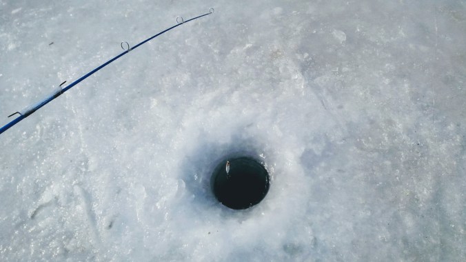


 Next I headed back towards the center of the island to the arts and crafts village where handmade goods can be viewed, created, and purchased. My favorite was a metal tree dripping glass globes that caught the winter afternoon sunlight. There were also plenty of places to grab a hot drink, a snack or a meal.
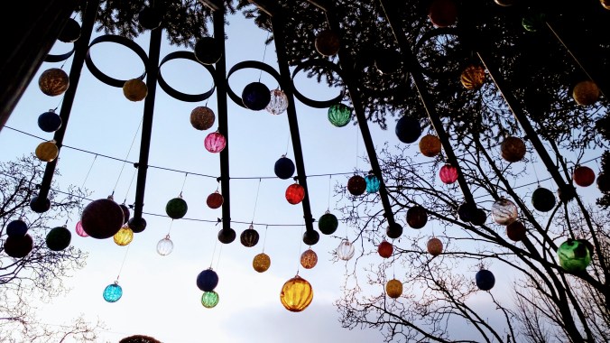


 We set off from Busan (blue dot) in the morning to drive all the way across the southern end of the Korean peninsula to Jindo (red dot). Although Korea is small compared to, say, the US, it was still almost 5 hours of driving with the occasional pit stop. (By the way, in case you’re curious, you can see Daegu on this map as well). Fortunately, I went with a tour group (my stand by
  The Jindo festival had at least one feature I’ve never seen before: a traditional Korean wrestling ring. A pile of sand was placed in a large circle where two contestants could wrestle in the traditional style.
  Even more bizarrely, after the color throwing was over, the festival organizers gave each participant a “toga” to wear. The togas were long white robes with red sashes that could have evoked a Roman senate or Jesus. Considering we were about to “part the seas” it was hard not to see it with Judeo-Christian overtones, but the rather drunk person I asked about it just said “toga party!” The entire thing seemed like the festival organizers were trying to find a way to appeal to the expat crowd. I’m glad they had fun, but I would have preferred some more traditional activities, like someone to teach us about collecting clams and seaweed the way the locals were doing as the tide went out. It’s hard to go do local culture festivals when the locals are busy trying to white-wash everything for cash.
 Finally, the real “reason for the season” was upon us and we muddled our way down the road to the rainbow steps beneath the watchful eye of the grandmother and the tiger. We paused at a bench to don our thigh high rubber boots and got some advice from the locals on how to attach the rubber garters through belt loops to hold up the boots, or failing that, to wrap them tight around our thighs and snap them in place. Thus clad in bright orange and yellow wellies, we made our way down the steps and into the shallow tide pools to wait for the tide to recede.
 If you look at the area on Google Maps you will simply see the beach and the islands, but on Korea’s own Naver Maps, there is a thin line connecting the rainbow steps to the island of Modo. Although this path is only usable twice a year (at most), the Korean map makers consider it important enough to draw in.
 The history of tidal prediction starts with Kepler (total nobody) in 1609 to theorize that the moon’s gravity caused the ocean tides. He was followed by other such no-ones as Galileo and Newton. It was in 1776 that the first big complex equations came from a man called Laplace. Harmonic analysis was added in the 1860s and polished off by 1921 in the form that Navies all over the world still use today. Although the math hasn’t changed in almost a hundred years, computers make the math easier and the information more widespread so now instead of just ships in harbor– surfers, beachcombers, and clam hunters can
  On a more mystical note, the local legend of the tigers explains why there’s a statue of a grandmother and a tiger overlooking the sea. Long long ago, the villagers who lived on Jindo were plagued by man-eating tigers. The whole village packed up and sailed over to the neighboring island of Modo to escape the threat, but one woman was left behind. The woman was Grandmother Bbyong, and she prayed to the Dragon King, the god of the sea, to help her. Finally the Dragon King came to her in a dream and told her he would build a rainbow brigde across the sea for her. The next day when Bbyong went down to the sea, the waters parted to let her cross and her family came out from Modo to meet her. This also explains the rainbow stairs that lead down to the landbridge, but not why her family couldn’t have just sailed back for her in the first place.
 While math can now easily tell us the time of the lowest tides, it does not yet advance to tell us what the actual lowest level of the water will be. Not that it couldn’t, but there are more variables involved, so it’s not a thing now. While we can say with certainty, the lowest tide of the year on this beach will occur at 18:38 on April 29 (or whatever), we can’t say for sure if that will expose the land bridge or simply be lower than every other tide around it.
 We tromped along the path, watching parasailers overhead and rainbow colored lanterns being released in to the air from the beach behind us. It was clear the path was quite narrow because going too far from the group to one side or the other to get a picture resulted in a severe deepening of water level. At the time, my friends and I theorized it might be man-made, or at least man-maintained, however, I have since then found that the build up of rock and sand in this twisty line is a natural result of the currents around the islands.
 Before long the golden light of the sunset combined with the swish-swishing of hundreds of feet through water to create a trance-like state. I could not judge how far the island was, nor tell which way the path twisted. The rocks below us rose and fell, bringing the waves treacherously close to the top of my boots and then back down to barely splash over my toes. The whole path is nearly 3km long. I suspect a determined person could make it out to the island and back in the hour or so the path is clear to walk, but I wasn’t racing, and soon we were greeted by the sounds of Korean drums and the distant flags waving as the procession from Modo came out to greet us.
 The walk outward had been slow, trepedatious, as though we were nervous the land could drop away at any moment, but the trip back was much more celebratory as well as much more damp. The parade of drum bangers, cymbal crashers, gong ringers and flag bearers danced merrily in their traditional garb, urging us all back to the larger island of Jindo. Our pace quickened and our legs swung to the rhythm causing much larger splashes. Waves came in from both sides of the path making us nervous, but excited. The water finally breached the top of my boots and sent an icy chill down my shins, but I found I did not mind.
 Before heading to the fields, we walked up a long road past the area of the light festival where a few wire frames from reindeer and dragons could still be seen. The road up the hill was painted with fun perspective illustrations of a stream, complete with little camera icons to show the best places to stand to see the visual effect. Optical illusions are fun.
 At the top of the hill, far beyond the little pagoda that had marked the highest point of the lights, we finally came upon the green tea museum where we were treated to a special showing of the Korean green tea ceremony (complete with English translation by our awesome guide). The ceremony involves a process of several containers: a water pot, a cooling bowl, a tea pot, and the drinking cup. The hot water pot is filled with boiling water, which is then poured into the bowl, and from the bowl into the tea pot and finally into the cups. The instruments are warmed up in this way. Then more boiling water is poured into the cooling bowl. Tea leaves are scooped into the warm but empty tea pot and the ideal temperature water is poured from the bowl over the leaves. While the tea steeps, each cup is emptied of it’s hot water into another bowl on the floor and wiped dry on the outside. The tea is then poured into the pre-warmed cups by pouring only a half a portion into each and the other half in reverse order on the way back. The tea is then served, 4 cups to the guest and one to the host.
 The hostess tried to tell us a bit about green tea, red tea and black tea but her translated explainations seemed off to me, since she said it had to do with the age of the leaf when it was picked from the plant. I don’t know if this was her or the translation, but the real story follows: In any country with Chinese roots in it’s culture and language, the three colors of tea are a bit different in meaning that in the West. Red tea is not Rooibos, in fact all three come from the same plant. And it’s not the age of the leaf at picking that determines the difference, but rather the post picking, pre-drying process. (although especially young and tender tea leaves are sometimes referred to as “monkey picked” and do make a delightful tea).
 After we conducted our own tea ceremonies, I drifted lazily back down the hill, examining the spring flowers and the grounds that had been lit up beautifully last December. When I finally got back to the tea fields, I took off on the same route I’d walked before and was happily greeted by many blooming apple trees and a small army of busy bees who were so focused on the brief blossoms that they paid no mind to all the humans fussing around. In fact, I think it was the only time I’ve seen Koreans in the presence of a bee not totally freaking out. I guess the selfie with the tree is worth it.
 In addition to the blooming fruit trees, there were cascades of purple flowers covering the rocks wherever tea was not growing. It made the whole place feel like a still frame of a rushing river in shades of pink, purple and green. Besides the tourists, there were also tea pickers at work. Each ajuma looking lady had her sun guards on, gloves and a mesh basket to place the leaves. They were not picking the bushes bare, but selecting only some growth. It seemed to me to be the newer, brighter green leaves that they were after, but I couldn’t tell for sure. In the age of automation it was strange to see people picking by hand. I know that it’s still the way for many crops in the world, but sometimes it gets driven home that there’s a human on the other end of my tea or strawberries or carrots, and then I’m carried off by sociological musings on how we came to value people who sit at desks manipulating imaginary money so much more than people who make our food.


