Wasn’t that in September? Yes, it was. Beleagured by work and play, by deadlines and soul crushing political discourse, it’s taken me a little while to get everything put together. The good news is that the second half of my Jeju trip was much better than the first half and includes a glimpse into Korea’s kinkiest theme park. My Loveland photos may be NSFW for you, I know they were for me!
Seongsan Ilchulbong Crater
 The weather was once more gray and drizzly, hot and humid, but with some sleep, breakfast and coffee behind us, we were enthusiastic to hit the road. I had done a bit of research on the crater that morning because of how the walk around the waterfalls turned out. I found some bloggers who claimed it was a 20 min walk if you just went straight up and about 40 minutes if you were a slow hiker. (it still took me about 45 that day). I felt better prepared for the hike ahead, but then we arrived late due to heavy traffic.
Our original schedule would have allowed us to get up to the top and come back down in plenty of time to see the famous “diving women”. However, the delay meant that the only way to climb to the top and see the divers was to race up. I decided that it wasn’t worth making myself ill, so I chose to climb at my own pace. It was another one of those hikes that should have been fairly easy but was made challenging by the weather. I soon realized that it wasn’t just us pudgy white girls that were having to stop and take breathers regularly. The Koreans, who so often zip by on mountain climbs, were also struggling in the humidity, and people of all ages and shapes were taking frequent breaks along the way as well as showing signs of being out of breath.
PS, the humidity was so bad that nearly all of my photos from the trip were adversely affected by the moisture, creating blurry and haloed pictures that I’m ashamed to put online. I tried to pick the best for the full album on Facebook, but I’m borrowing some tourist advert pics here. Sorry!

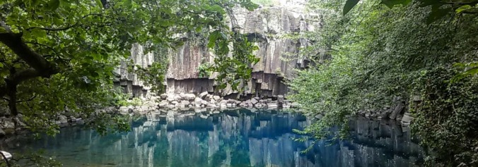
When we finally reached the top, it was clear the effort was worthwhile. The crater was formed by a volcanic eruption about 5,000 years ago. Since then, the wind and water erosion have moved the vocanic soil around and connected the crater with the mainland by a narrow land bridge. The view from the highest segment of the ring overlooks the deep bowl and surrounding stone ring. The crater itself was filled with green and the sea spread blue-gray in the distance. We bounced around the viewing platforms, which were made as giant steps to allow people to stand above those in front of them and not have to jostle for the front line. We took photos for ourselves, for random strangers, and had strangers take photos for us as well. Everyone at the summit was in a celebratory mood and it was exhilarating to be at such a beautiful natural display while shoulder to shoulder with a hundred or so happy and excited people.
As I predicted, we missed out on the diving women, but further research shows that it’s not actually that much to see, since all the action takes place under water. We managed to find some pure Hallabang juice (which I was very curious about since it’s famous and unique to Jeju, it’s a variant on the orange/tangerine theme, sweet and light, not at all tart) and a place selling chicken skewers in time to scarf down lunch before the bus headed off to the next locale.
Lava Caves

The lava caves at Manjang Gul are a unique kind of cave formed by flowing lava rather than by water erosion. We have some in North America. In fact, I got to hike the Ape Caves’s by Mt. St. Helens a few years ago and those are the longest congigous lava caves in North America (Hawaii boasts the longest in the world, btw). I was interested to see the ones in Jeju, but was a little sad to find out only a 1km stretch of the tubes is open to the public. Safety, safety, safety. In Oregon, we hiked the Ape Caves alone with only our own flashlights for guidance, scrambling over piles of rocks and at one point navigating an 8ft wall with only a short length of rope secured to the rock to aid us. In New Zealand, there were limestone caves that would require special gear and plenty of squeezing through narrow gaps and were still open and unguarded. But in Korea, the cave was carefully lit with color changing lights and each rock formation that might have been even the teeniest bit not-flat was cordoned off to protect people from climbing on it. It certainly helped me to understand why my students thought my trip to NZ was so dangerous.
Nonetheless, as we descended into the cave opening, the cool underground air was a welcome change from the stifling late summer humidity above. It was also fun seeing sections of the cave fully lit. The last time I’d explored a lava cave, I could only see a small portion of it at a time. There were signs and infographics explaining various formations, and there were certainly better photo opportunities than in any of the unlit caves I’ve been in. I really appreciate the fact that Korea has made so many interesting things so accessible to people with small children or physical limitations. My only complaint? You can guess by now, not enough time. I hear there’s a pillar of sorts at the very end of the tunnel, but we never made it because about ¾ of the way down, we realized we had to turn back if we hoped to make it to the bus on time. And I wanted to be on the bus on time, because our final stop for the day was Korea’s kinkiest theme park:
Loveland (NSFW pics)

When I first saw Loveland on the tour itinerary, I thought, oh it’s probably some romantic couples oriented thing with tunnel of love rides and romantic couples cafes and two person everything. Then I did a Google Image search, and channeled the voice of George Takei.
Coming as I do from Seattle, where 50 Shades of Gray was dissected in minute detail for it’s many inaccuracies and misrepresentations, I might have a culturally different idea of “kinky” from most of the rest of the world, so, just to be clear, Loveland is really Sexland, but not anything wild. Pornography is not legal to make or own in Korea yet, so the park is a much more unique experience for Korean visitors than it is for those from countries with a thriving pornography industry. It’s mostly vanilla with the occasional nod toward the existence of other flavors. However, if artistic renditions of naked sexy parts offend thine eyes, scroll past quickly to the next section.
The park is filled with larger than life statues of erotic and sexual poses. Full bodies, body parts, foreplay and coitus. There is a giant hand stroking a giant vulva on the ground, as though someone is trying to bring mother earth to orgasm. There are several climbable giant penises. There are no “do not touch” signs, so basically everything is interactive for all the photo ops you want and several statues are designed to be only part of a picture and are clearly in need of a partner. There are a couple of gift stores and a sort of museum of smaller sexual art depicting vibrators and masturbation aids from around the world, wooden carvings of penises, and miniature dioramas of sexy scenes in ancient and modern Korean cultural settings.


The best part about the park, however, was the fact that once inside it, all the people seemed to be totally free from sexual embarrassment. People who, in normal life, would blush or stutter to talk about sex were suddenly giving full belly laughs at the little clockwork couples who you could make fuck with the crank of a handle, they were grabbing statues’ breasts and butts, gender roles mattered less and less as people posed with sexual statues the same gender as themselves without fear or homophobia, they asked total strangers to take pictures of themselves in compromising poses, and even when I squeezed my breasts into the outstretched statue-hands of a woman in ecstasy, I got no rude glares, but only smiles and thumbs ups. It was like some unspoken agreement that hey, we’re all adults, we all do this stuff or wish we could, so there’s no point pretending today. Oh, and not once did anyone of any national background try to use the freeing atmosphere of the park to skeeze on or harass another live person.
Rain Rain and more Rain
By the time we got back to the hotel, we knew 2 things: 1) there was no way on Gaia’s Green Face we were climbing Mt. Halla for 7 hours in that weather, and 2) we were definitely having a good vacation. We stayed up far too late, sitting by the pool and chatting while watching other groups around the courtyard play a variety of drinking games, and even got to help one lucky girl ring in her birthday by joining the sing-song. We went to sleep hapy in our decision to skip out on the mountain and to spend our last day of vacation on the beach, enjoying the water even if it rained and maybe even finding a secret hidden cove on our own.
The next morning brought a slightly different reality. Some time while we had slept, the weather turned for the worse, from merely rainy to outright typhoony. The main difference is of course the wind. For beach going, we weren’t too bothered by rain, since you get wet when you swim anyway, but the experience at Jungmun told us how bad the riptides here could really be, and we didn’t want to sit on the beach all day and not be able to swim again. During breakfast I watched the palm trees blow sideways. Our day’s buses were scheduled to leave late, so my friend and I tried to go sit outside under a canopy for a while to see what it might be like. Even under the canopy, we quickly became soaked and we had to hold on to everything we brought with us lest it be blown away by the wind. Finally, we had to admit defeat and start looking for a rain plan.
The tour group decided they would run an extra bus to the downtown area, so we started our search there. Downtown Jeju City is not terribly different from other large Korean cities, but we still wanted to do something unique to Jeju. The main obstacle here is that Jeju is famous for it’s outdoors. No one comes to Jeju to stay inside. All the activities are outside, even many of the museums are combination museum and park. Finally, I located the Yongduam Seawater Sauna and Jimjilbang. Jimjilbang are all over Korea, but I hadn’t actually made it in to one at the time of this trip, and on top of that I gathered that this one is unique because it pumps in water from the sea for some of it’s bathing pools.
Samseonghyeol Temple

When the bus dropped us off, we spotted a sign for a museum and headed toward it, but before we arrived, we passed by the gates of a temple. I’m a sucker for temples. I expected it to be Buddhist, because so far that’s what every temple I’ve been to here in Korea has been. In Japan, there were Buddhist and Shinto temples, sometimes side by side. In China, there were Budhhist, Daoist and Confucian temples. Since arriving in Korea, I’ve realized how little I actually know about Korean religion pre-Buddhism, despite the fact that I actually minored in East Asian Indigenous Religions at school. It’s not from a lack of interest, but I realize I haven’t read a single book on Korean religious history. As a result, I was surprised and delighted to discover that the Samseonghyeol Temple in Jeju city is not Buddhist at all, but rather it is a temple to honor the three gods of Jeju Island. (side note, this doesn’t mean I know more about Korean religious history, since as it turns out, Jeju history and culture is separate from mainland Korea. Mainland Korean shamanism is called Muism or 무교 and I’ll be reading about that for while.)
 According to the legend told at the temple, the first inhabitants of Jeju Island were three demi-gods who came to earth in a great flash of light and energy, and emerged from three holes in the ground. The temple is built on the site of these three holes, and no matter how much it rains, the holes never fill up with water. The demi-gods were named Go (고 / 高), Yang (양 / 良), and Bu (부 / 夫). They wore animal skins and hunted for food. They were of great strength and cunning, but they were alone. One day, a ship arrived on the coast and an old man came out to meet them. The old man said that he was a king of a distant land and that when they had seen the great flash of light, he knew that he must travel there with his three daughters to find husbands worthy of them. The demi-gods accepted the women as their wives and their new father-in-law gifted them with the five grain plants and several livestock animals including cows and horses. In fact the last horse to leave the ship landed so hard that it’s hoof left an impression in the rock that can still be seen today.
The marriage service was held at what is known today on the island as Honinji (literally “marriage pond”). Before the wedding ceremony, the young demi-gods bathed in this pond. Neaby there is also a cave called Sinbanggul that has three rooms and where the brides readied themselves beforehand, and the newlyweds spent their honeymoons afterward. Both the pond and the cave are landmarks preserved as the three holes are.
The couples used the gifts of grain and livestock to establish the first farms of Jeju. They began to trade with other countries including China, Japan and mainland Korea (which historical records support). Once the farms were well established, they decided to each create their own separate governments. In order to decide where each family would begin their own districts, the three demi-gods each shot a single arrow into the sky. The arrows landed on three different parts of the island: one in Il-do, another in I-do, and the third in Sam-do. These names are still in use today.
I find it interesting that the founding demi-gods were effectively hunter-gatherers. The descriptions of their animal skin clothing and hunting lifestyle indicates that they were very similar to our own understanding of pre-agrarian human cultures. Typically, gods and demi-gods in origin myths have all the trappings of civilization which they then bestow upon the humans as gifts (or sometimes have stolen from them). When the king and his daughters arrive, they are depicted as wearing beautiful clothing of woven and embroidered cloth, and bring gifts of grains and livestock. This is an obvious transition from hunter-gatherer to agricultural civilization. The transition is often told in myths, but this one was unique to me because the roles of human and divine were reversed.
The Tamna Kingdom remained a separate country until the 1400’s when it was absorbed into the Jeoson Dynasty of Korea. Even after this, the people of Jeju were still treated as foreigners and travel was restricted so there were many conflicts and more than one uprising. In 1910, Japan annexed Jeju along with the rest of Korea. And finally, today, the Island of Jeju is the first and only self-governing province of Korea.
 After watching an informative film about the history and mythology of the shrine and the island, we wandered through the paths in the quiet woods. There are almost 1000 trees in Samseolhyeong. The other buildings included the museum where dioramas of the myth were displayed along with some of the original writings and ceremonial clothing from the earliest rituals performed starting in 1562. Additional alters, shrines, dormitories and halls were added over the years, but most were destroyed during Japanese occupation. Although the site of teh three holes is the same, the modern temple complex was rebuilt here in 1970. The walk through the trees was a refreshing break from the hot and humid weather. We admired many bangsatap (small stone towers built for luck) and more than a few dol hareubang (the stone grandfather statues that are the iconic image of Jeju).
We emereged feeling newly educated and refreshed and ready to enjoy our afternoon plans at the spa.
Jimjilbang at Yongduam
Just about every blog I’ve read about Korean jimjilbang starts off with “eeeek! Nakedness!” or some equivalent. I’ve seen people refuse to even try to go for fear of nakedness, and I’ve seen people talk about how they plucked up their courage and averted their eyes and tried it anyway. But pretty much everyone feels the need to talk about how scary it is to have to get naked, be seen naked, or see other people naked. It seems a great many westerners are well and truly freaked out by the prospect of being naked in a non-sexual setting. This may tell you some things about western culture?
The jimjilbangs are not unlike the Japanese onsen. These are strictly gender segregated, and they are about enjoying the baths. Nakedness is not shameful, scary, or sexual here, it’s just how you bathe. When we got to the front counter, I managed to communicate to the woman there that we wanted to do the baths and the saunas (it’s a different price point, but only by about 2$). We were given pink T-shirts and shorts (the men had blue) and a few small towels then directed to the women’s entrance. This place seemed to be owned or at least operated by and for Chinese tourists because the vast majority of the signs were in Chinese and Korean (not much English around). We put our shoes in lockers in one room and headed further in. In the main changing area, there were more lockers where people were able to change and store clothes and bags. I wasn’t sure yet what our pink clothes were for, but as we tried to change into them, a somewhat beleagured staff member patiently explained in Korean and then again in Chinese that we only needed the pink clothes to go up to the second floor.
We quickly stowed everything in our lockers and headed, yes naked, into the bathing area. This room had 6 pools of different temperatures and mixtures as well as a dry sauna and a wet sauna. But before we could start soaking, we had to scrub. About a third of the room was dedicated to getting clean. It’s important when sharing a bath with strangers that everyone cleans up first, so we got some soap and scrubbed down with the rest of the ladies. We were the only non-Asians in the place, but people mostly ignored us. The scrubbing process is not a shy rinsing off. Think about everything you do in the shower to get really clean and know that that’s what everyone was doing here. It seemed it was also possible to hire someone to give you a massage, or even give you a good scrubbing while you sat at one of the cleaning stations.
Once we were scrubbed, we headed over to investigate the pools. There were several sea water pools, as wells as some fresh water, and some herbal infused. Some pools were still and others had jacuzzi jets. One pool even had a jet in the ceiling that when you pressed a button, sprayed an intensive force of water downward, letting you stand under it to pound away at the muscles of your back and shoulders. We started in a marginally hot sea water pool that was filled with volcanic rocks along one edge. When we got too hot, we moved to the cool water pool. We tried the super jet. We wandered in and out of the jacuzzi pools. We even tried the iciest pool to maximize the hot cold contrast. Gradually, my stiff muscles from days of bus rides and hiking began to unwind. The dry sauna smelled intensely of cedar and was too hot and dry for me, but my companion enjoyed it. I visited the wet sauna which was hot and steamy, but the walls of the room were made of a mosaic of semiprecious stones like amythest and rose quartz in geometric patterns.


After a couple hours of this, we decided it was time to investigate the mysterious “second floor”. We dried off and put on our pink clothes and followed the signs to the stairwell. The second floor turned out to be a clothed co-ed area where people could relax, eat, watch tv, and sleep. Jimjilbang are a popular overnight destination for people traveling on the cheap because they are open all night and offer these communal sleeping areas. (It turned out the basement had even more sleeping areas and a dedicated DVD room!) We got a simple meal from the small restaurant there, enjoyed the coin operated massage chairs, ate some ice cream while admiring the view of the sea, and finally decided to explore the unique jimjilbang rooms.
 There were 3 special rooms along one wall of the second floor: the red clay room, the amythest room, and the gardenia room. The rooms had little doorways and were quiet and dark inside. Places where people sat on mats or lay with their heads on wooden blocks to relax or nap while enjoying the atmosphere. The red clay room was warm, but not quite sauna warm. The walls were red clay and it resembled the inside of a clay oven. I don’t think I could have stayed for long in the heat anyway, but we were driven out by one man’s snores before that. The gardenia room was a truly sauna level of hot. There was a stong floral (presumably gardenia) smell in the air, but the heat was too oppressive. My bare feet singed on the floor as I hopped to a reed mat for protection. There were many women sitting on the mats but the air was too hard for me to breath for long and I hopped back out without even sitting down.
 The amethyst room is by far my favorite. I had fallen in love with the beautiful stone mosaics in the wet sauna below, but this room put them to shame. Jasper, quartz, amythest, and many others were used to create beautiful scenes of village life and cherry blossoms. The temperature in the room was Goldilocks level’s of “just right” and I lay on the floor there for a good 20 minutes enjoying the play of the low light on the colored stones, feeling like I had crawled inside a geode.
With only an hour left, we headed back down for one more round of soaking in the baths and it was with some reluctance that we took our final shower and donned our street clothes to make our way to the bus rendevous. Even leaving ourselves 45 minutes to travel what should have been 10, we almost didn’t make it. There were no taxis anywhere to be seen and the city bus stop had no timetable to show us if another bus would even come. We asked some clerks at a convenience store to call a taxi for us, which they did attempt to do, but we were told no taxis were available! Just as it seemed all hope was lost, we finally flagged one down and made it back to the group with minutes to spare.
The Moral of the Story
This trip taught me a couple very important things.
One is that even if I’m going with a group, don’t rely on anyone else to know what’s going on. By the third day, I had no choice but to do my own research because our entire primary and secondary plans for that day were scratched. I skimped on researching Jeju because I spend so much energy researching New Zealand (and then speeding through my rough drafts to get them done before leaving for Jeju) and because I thought a tour group of locals who had done the annual island trip more than once were likely to know what they were doing. I basically looked at a few pictures on google enough to know that I wanted to go to the places they listed on the itinerary and left it at that. I know now, based on my experiences and research that I would have chosen a different plan for myself even if I’d still ended up going to nearly all the same places.
The other is the value of traveling with a good friend. Experiences that would have been a big fat bummer if I’d been alone became endurable or even fun and silly because of the company. I like travelling alone, too, but just like Taean’s many travel disasters were mitigated by the presence of my Busan Buddy, the Jeju trials were made well by my Seattle Sister. We took turns managing each obstacle and when one of us got overwhelmed, the other was there to pick up the slack. I really do believe that it turned what could have been a mediocre holiday into a great memory.
There were hours of bus rides and long evenings by the pool and crazy mornings trying to pack everything we needed for the day in tiny bags and that made up at least as much time as the beaches, museums and parks. I’m not dedicating a lot of blog space to the story of how I got irrationally upset my towel wasn’t dry overnight and she busted out a hair dryer to get it dry for me, or how she got super seasick and I spend a couple hours of ferry ride dashing around the boat to bring her things to help her feel better, or how we stayed up late into the night philosophizing about the better angels of our nature or the etymology of the suffix -izzle, but that does not mean that these were less meaningful and impactful portions of my holiday experience.
Sometimes the company and the journey are the destination.
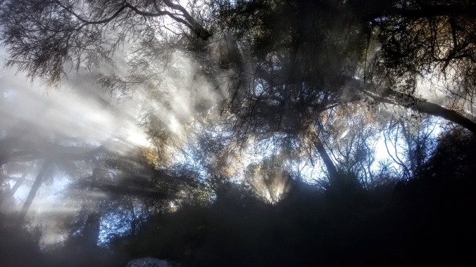
 There are signs at every natural hot spring that basically warn you of 2 things:getting burned and getting sick. Because these are natural springs, the temperatures are not regulated, and water that is hot enough to burn you sometimes rises up from the ground in the river and pool beds. You can be sitting in lovely water and suddenly a hotter current will come by. You can take a step to the left and land on a patch of mud that is scalding hot. However, these are not insurmountable problems if you exercise a little caution and common sense. Don’t dig down into the mud/sand at the bottom. It’s hotter below the surface. Feel before you put your weight down, test the bottom gently with a hand or toe before you put your weight down so you can move away quickly if it’s too hot. If you’re really worried about it, you can always wear water shoes. The other thing to bear in mind is that hot water breeds microbes. In the case of the Rotorua springs, there is a small concern of amoebic meningitis. That sounds scary, but it can’t infect you through your skin, only if it gets up your nose, so just keep your head out of the water and you’re in the clear. If all this sounds like too much work, that’s why the spas exist.
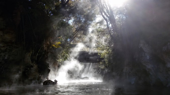
 There’s a beautiful and fairly large waterfall there and a pool that’s deep enough to sit in and have the water come up to a comfortable chest level. This spot is

 Not wanting to find my car locked up in the visitor’s spot, I
  The first thing you see is the top of the falls. These are quite lovely and worth a gander, but the water up here is too shallow to enjoy a soak, so head on down the trail a little further and you’ll find the pool. Despite it’s lack of popularity, it was indeed marked with another Dept of Conservation sign warning us about mud burns and amoebic meningitis, so the government was clearly aware of the fact that people were coming here and was just as clearly not prohibiting it. Ostensibly, this is a result of the Queen’s Chain policy of reserving 20m of land around bodies of water (and prohibiting the private ownership of said water).


 After eating and stretching our legs, the buses moved on to Dutayeon. The area of Dutayeon is beyond the Civilian Control Line, was closed to civilians after the Korean War and was only recently reopened to the public in 2006. It’s still necessary for us to register ahead of time with the government in order to visit the area, and for some of our group to wear GPS tracking necklaces around while in the park. Of course I volunteered to wear one for our group. Are you kidding? The Dutayeon Park area also includes the warning: “Not all landmines have been found, so stay within the permitted areas.” It’s not your average hike in the woods.
 That being said, it is a beautiful area. The river that runs through it ends in a small but powerful waterfall that is the crown jewel of the park, visible across from the pond and from viewing platforms on both sides. There is a loop trail around the park, so it doesn’t matter which way you go from the pond. We headed right and passed by quite a large number of unexploded mine signs on our way toward an outdoor exhibit of mines used in the war,
  as well as other security measures and a mock explosion that demonstrated the sensitivity of the mines by blowing foam bits around in a ball while playing a low volume explosion sound whenever hikers came too close. There were also many happier decorations including party banners between trees, wooden deer and pigs, and a whole wall of paper prayers and wishes.
  After crossing the brigde, we followed more winding forest paths through beautiful red trees. We climbed up some stairs to get to a viewing platform just above the falls and then continued on further upriver. When it came time to cross again, there was no bridge, but instead a trail of stones that required us to hop across. Most stones were large enough to allow two people at a time, but not all. Some stones could be easily stepped between and others required jumping. Plus, everyone wanted to stop in midstream for a geourgous photo-op. The end result was a long and patient crossing while trying not to get bumped into the water by people crossing the other way. This was mostly acheivable, except for when the Ajuma needed to pass. These are the ladies who wait for no one and push everyone aside to pass. Behavior that is just rude and annoying on the subway suddenly becomes hazardous when trying to balance on river rocks. Oh, Korea.
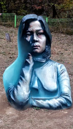 Back on the near bank, we followed the trail up to a gazebo/pagoda hybrid that overlooked the waterfall once more, before following a side trail up and over to a sculpure garden that included various works of outdoor art inspired by the war or the peace as well, as a missile and several tanks that were leftovers from the fighting. One of the most fascinating pieces was a painted sculpture that blended 2d and 3d art. The sculpture was the bust of a young woman, but only half of it was painted realistically, the other half had been painted blue. In addition, the depth was unrealisitc as well. The combination created an illusion of a different perspective of portrait from each angle as you walk around it. There was also a kitchy photo frame where we took a group shot, and a copse of giant eyeballs which was meant to show the sourse of all the tears shed for those lost. There were art pieces made from the objects of war, such as the barbed wire dandilion, and other shapes made from reforged metal. All in all, it was a surreal yet emotional tribute to the history and tragedy.
 From the park, we wended our way over to a small war memorial. Mostly we stopped here because it was necessary to file more paperwork for the Eulji Observatory. The memorial was very artistic and very sad. There were nine pillars representing the nine big battlefields in the area (Dolosan, Daeusan, Bloody Ridge, Baekseoksan Mountain, Punch Bowl, Gachilbong, Danjang Ridge, 949 Hill, and Christmas Hill), as well as statues of soldiers, displays of weapons and a whole room the floor of which was covered in shell casings from the war. Growing amid the barbed wire and destruction were small and beautiful flowers. There was a poem there ending in the stanza:
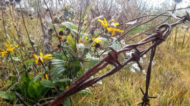 While reading these lines, I stood over the discarded shell casings, and under the helmets of dead soldiers, my camera filled with photos of beautiful flowers growing around the site. Although small and far less grand than the UN Memorial in Busan, the closeness of things these men had touched or died in amid the natural beauty of wildflowers and creeping red ivy brought the tragedy of war far closer to my heart than a cemetery or a statue ever could.
 I could see one winding dirt road, some tires stacked and filled with dirt or sand to create a barrier, and a lone watchtower surrounded by more barbed wire fencing. Beyond these decrepit signs of occupation, the land seemed as wild and untouched as though looking back in time to before humans even arrived. Coming from South Korea, where all the land is so thoroughly occupied that wildlife is all but vanished, it was a stunning contrast.
 Inside the observatory, there is an enclosed viewing platform that overlooks the North. A brave soldier who spoke some English decided to read an English presentation to our large group. He was very nervous, but it was a great gesture that he wanted to share information with us, so we filled the small auditorium and listened politiely while staring at the mist shrouded emptiness behind him. He told us about famous battle sites around the observatory including Stalin Hill, where the South lost some land that is now part of North Korea, a radio tower used to block signals traveling into the North, and a distant waterfall called Fairy Waterfall where beautiful North Korean women used to bathe nude to entice South Korean soldiers. He also indicated that North Koreans did use the area nearby for agriculture, although to my eyes it looked completely natural and I cannot imagine that the food they harvested there would be anything more than wild gathering.
 I stepped back outside, feeling disoriented from the whole experience, looking back and forth across the narrow fence from a high vantange point where I could easily see North and South at the same time. (hint, the South is on the right, the North is on the left) Large ravens swooped around the peak, effortlessly gliding between the two countries gripped in cold war, alighting on the Northern watchtower, then returning to our parking lot to scavenge for crumbs left by tourists.
 Our last stop for the DMZ day was the 4th Tunnel. This sounds fairly ominous, because it also implies there are at least 3 other tunnels, which there are. The North has tried on at least 4 occasions to literally tunnel into South Korea to get troops behind the border for a massive attack. Before heading over to the tunnel entrance, we scooted inside the nearby museum for a quick propaganda film. The film was in Korean, but had English subtitiles. They were long, small and hard to read over the video, as well as not being the most accurate gramatically, but I got the gist: North bad, South good, Threat onging. The idea that the Korean War is over is not something that really exists up near the border. To be honest, it doesn’t really exist in Korea at all, but most of the time Korean citizens can ignore their war with the North the same way Americans don’t let the 7 wars their country is involved in affect them on a daily basis. This film was a little startling however, because it didn’t even make an attempt at looking like an “unbiased documentary” and was more in a tone in keeping with propaganda material from the 1950s-60s during the cold war with Russia, or the modern Chinese government propaganda films. I’m not sure how old the film was, but it certainly felt out of time.
 After the film, we filed into a large round tunnel. The tunnel we were walking into was dug with a serious drill by the South Koreans in order to reach the less sophisticated North Korean tunnel. It was a long walk, less than 1km I’m sure, but the tunnel was dim and damp and nearly perfectly circular thanks to the diamond tipped drill the Koreans had used to make it. Hard hats were available at the front, but there were nowhere near enough to accomodate our group size, so we simply left them behind. Inside the tunnel was another no photos zone. Fortunately, the internet provides, so you can see some photos that other people (including authorized tour guides) have taken of the tunnel and equipment.
 Where the modern and sleek South Korean tunnel ended, there were clear toolmarks in the rock, concentric circles left by the drill. Intersecting our tunnel was a much smaller one, no more than 2 sqare meteres, and rough hewn, carved out with picks and dynamite. A small train awaited us, one seat behind the next as the tunnel was too narrow for two abreast. The seats were low and a transparent panel protected us from the threat of falling rocks above, but the sides remained open. We climbed in, feeling even more like boarding a ride in a theme park, expecting a trek through the rugged rock. After a mere 100 meters, the train came to a stop. We could see tool marks, and holes that had been prepared for the next round of dynamite. I forgot for a moment about the photo ban, but when I snapped a few, the soldiers only politely reminded me not to and I put my phone away again.
 The parking lot had more tour buses than Disney Land, and when we passed through the main entrance, we were greeted with a wide stone road lined with restaurants, cafes and other businesses catering to park-goers. There are several trails that can take over 12 hours, but we didn’t have that much time. After doing some research, my companions and I decided we would see the big Buddha, then walk the short (2 hr) waterfall trail, and finally take the cable car up to the highest peak for a look around.
 Our tickets in had, we followed the signs toward the temple, passing more and more restaurants, cafes and other buildings of unknown purpose. We rounded a corner and spotted the giant statue from a distance and made a bee line straight for it. The first thing that struck me was how similar it was to the
  Trying to keep ourselves on a decent timeline, we said our farewells to the stunning statue and set off in search of the trail-head to Biryong Falls. We soon joined a stream of Koreans dressed to the nines in their special hiking clothes. For many Koreans, espeically the older ones, outdoor activities are a serious glamour show. All the clothes are brightly colored and brand new looking. Meanwhile, my friends and I were dressed in jeans and hoodies because that’s usually how we walk in the woods at home.
 The path involved some beautiful views of the surrounding mountains. Unlike the Busan mountains which are low and covered in a softening green layer of trees, the Seoraksan mountains burst from the treeline with jagged teeth of bare rock, and this day, the whole thing was wreathed in clouds and mist making it even more haunting. We took a wide bridge over a river and ambled joyfully along the forest path, stopping to admire the trees on a regular basis. The Koreans around us took some pictures, but only at designated picturesque spots. The rest of the time they were in a hurry to get moving. So much of a hurry that we were jostled, bumped and even shoved if we were deemed to not be going fast enough. It was like being in the subway… for several km. We tried to walk on the side of the path, or even just step OFF the path when the hordes of ajuma came barrelling down on us, but it didn’t always work.
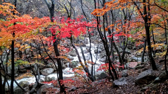
 As our path ascended beside the river, we were treated to the kind of views normally reserved for high class calendars and natural beauty screen savers. My computer randomly shows me stunning nature pics every time I log in, and I swear that one of them was actually from Seoraksan. We climbed up the slippery rocks, clinging to the railing and nearby trees until we reached two more bridges crossing the lower Yukdam Falls. The maps and pamphlets all say it’s just a 40 minute hike from the main entrance to these falls, but it had taken us close to 90, proving that 40 minutes was measured by ajuma walking standards rather than beautiful day in the woods standards. I understand that Biryong Falls was only a little farther up the mountain, but in order to make our cable car time, we had to turn back early.
 Our last adventure for the day was to take the cable car up to
  As we rose, the clouds soon fell below us, covering the view of the ground and the sea became visible off to one side. I had known Seoraksan was near the coast, but I had not realized how close to the ocean we actually were until that moment. The cable car stand at the top had more amenities, food and restrooms and coffee shops, but we swept past them and onto the viewing platform. I had read ahead of time that one could walk all the way to the tippy top from here and see an old castle, but after my experience on the waterfall path earlier, I was reticent to follow another stream of hundreds of hikers. We walked around the viewing area and found a distant waterfall, a long streak of white amid the green and brown of the mountains, visible even at this distance it must have been enormous up close.
 While searching for more and better angles to take majestic photos of the panorama around us, we stumbled upon a small path leading downward that
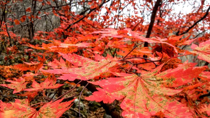


 And there’s the riots, which I am not happy to see. I don’t want violence to be an answer ever. Yeah, I know, the Trump supporters did it first, but now that they’ve won, they’d like it all to stop. People are like “oh you’re overreacting”, “oh you’re whiny cry babies” (nevermind that’s been pointed at us for caring about anything ever for decades, so it’s lost it’s oompf as an insult), but I voted in 2000 when this happened with Gore and I was not scared for my nation’s future (although, it turns out I should have been). I was mad when Kerry lost in 2004, too because that explitive promised to do recounts and bailed. And the Democrats didn’t take to the streets in protests and riots because voters who lost an election were capable of telling the difference between a guy we didn’t like the policies of, and a guy who we honestly believe will enable the ruination, incarceration, and deaths of humans we care for and respect.


 They told me that’s the normal price for SPAM, it was just in gift boxes this time of year. This led to a whole side discussion about the cultural dissemination of
  The only real hitch was that we were taking the ferry from Mokpo instead of a plane. This meant a 4+ hour bus ride
  After we ate, we headed down to the water to frolic! The weather was gray, but warm. At first the water seemed chilly, but as I waded in further, I quickly adjusted. This beach was wide and shallow. We walked out for ages from the shore but the water didn’t even come to our hips. There were some Koreans playing in the water as well, but it seemed that only the Westerners wore swimsuits, everyone else went in the water in clothes. I’ve seen this at the beaches in Busan as well, and I’m still not sure what the cultural aversion to swimwear in the ocean is.


 The best view of the falls was obscured by the trees and vines growing around us and was from quite a great distance. I felt cheated. I think it may have been a beautiful waterfall, but the fact that we weren’t able to find out after so many stairs just felt like a bad con. And unlike waterfall 2 which was relatively easy to hop the fence and get closer to, this platform was high above the pool with a very steep and overgrown hillside, making navigation any closer dangerous and difficult.
 We went first to Chocolate Land because, well, chocolate. For some reason there was a giant statue of the Incredible Hulk outside. I don’t know what I was expecting, maybe giant chocolate sculptures or the world’s biggest M&M, possibly a history of chocolate exhibit, or a making of chocolate section. What the ‘museum’ turned out to be was a room (just one) sparsely populated with display cases showing off packaged candy from various countries. Even this could have been cool if they’d said something about it, why is the Arabian chocolate this way and the British chocolate this way… I tried the Kazakhstan chocolate my friend brought me from her visit home after all and was fascinated to learn the pride that the country takes in it’s national brand. But no, these cases just held boxes of chocolates. Some cases made an attempt at silly displays, like a taxidermied chicken with Cadbury eggs or a Nativity Scene made with chocolate coins, but it was incredibly grandma’s yardsale chincy.
 Half the room was filled with what seemed like Christmas themed facades that were, I assume, photo ops as well as a cafe where one could get some coffee, soft drinks, ice cream or candy and relax from the arduous walk through the musem. There was a chocolate making “class”, where for 12,000W you could pour some melted chocolate into molds. Outside there was a statue of Willy Wonka, but the Depp version, not the Wilder one. The final room was divided between more odd displays that seemed to have even less to do with chocolate than the ones before and the gift shop where one could redeem the 3000W entrance ticket toward the price of a sovenier. It turns out Jeju chocolate is quite tasty. They make it in fruit flavors that are unique to the island like Hallabang, Jeju Mandarin and Jeju cactus. The same boxes of chocolates are on sale all over, so it was basically like getting a 3000W discount on some chocolate I would have bought anyway for walking through a weird display room.
 The trunk of a California redwood had been taken apart, transported and reassembled there so that the Koreans could see the stunning size of the redwood trees and experience walking inside the hollow trunk. It struck me that this was as close as most of them would ever get to a redwood and reminded me that museums aren’t just for history, but for the exchange of personal experiences. The most ridiculous thing there was the map of all the places in the world that Ripley had travelled. The map was covered in numbered blue dots with a key below. As we started to try to identify some of the places in the US, we realized that the geography was woefully inaccurate since Siam, Yugoslavia and Burma were all listed as being in the continental 48. Yugo-Slavia [sic] is in Florida.

 On our way past the beach restrooms we reached a point where the floor and walls seemed to move and I realized with horror that the whole path and retaining walls were COVERED in cockroaches. Horror movie levels of roaches. I am not afraid of most bugs. I can be startled by unexpected bug and I have a healthy respect for things that can hurt me, but there is something deeply lizard brain *ACK* about realizing that a good portion of your surrounding landscape is made of bugs. Fortunately, they didn’t want anything to do with us and moved clear of the path as we approached.
 Back to New Zealand. It’s like time travel, or at very least like one of those novels that writes chapters from all different perspectives or storylines. You can see my trail through the north island here, starting in Auckland and then looping around Northland before swinging wide to the East and Coromandel Peninsula. Also, I’m afraid that the night-time stories don’t have accompanying pictures as I have not yet acquired a camera that actually shoots well in the dark. Think of it as imagination exercise.
 My breakfast spot was nearby a public restroom and shower as well as a totally different path down to the water. When the hours lengthened enough to head to the beach, I wandered over to the changing rooms and got kitted out with my suit, sunscreen and shade hat. The clear sky of the night before had carried over into the morning and I didn’t want to get sunburnt while soaking up my hot spring. The beach was also quite full of people. I was even more glad in that moment that I’d had the chance to spend a few hours the night before in silence and solitude. I love people and I had a great time chatting with the other bathers that morning, but I am grateful it was not my only experience of the beach.


 Although Cathedral Cove car park is a mere 10 minutes up the road from Hot Water Beach, there is a further 45 minute hike (according to the sign) to the cove itself. The cove is not accessible except by taking this walk or by kayaking in from another point. It is famous more for it’s breathtaking beauty than for any particular historical importance, although it was used in the filming of
  The timed signposts for trails in NZ were a bit frustrating to me because there was absolutely no way to know how fast one should walk to achieve this time. I’m perfectly capable of walking quickly, but I like taking my time on a forest walk and I can better judge my time if I know the length of the walk instead of the average hiker’s time. Average flat ground speed might be 5kmph, but of course rough terrain can change that too. Waipoua said about 40 minutes for the walk out to Te Mata Ngahere and back (very smooth trail), but I took about 2 hours because of all my stopping and looking. Waipu said 1.5 hrs for a 2km trail (very steep), and I took a little over 3 hours exploring things and watching the wildlife. So when Cathedral Cove said 45 minutes one way, I was skeptical. However, even with my frequent stops I still did manage to
 make it in about 50 minutes, so well done on those sign makers.
 of the hole is the actual cove named Cathedral, but since I had left Hot Water Beach as the tide was coming in, I was loath to wade through the waves to reach the other cove, not knowing how fiercely the water level would be rising or how wet I would get trying to come back. Remember, it’s winter in August and I already knew just how cold that ocean was.
 The sun was also low in the afternoon sky when I arrived, casting the coves into shadow. There is no doubt that this beautiful area is well worth a visit, but next time I’ll be sure to come down in the early morning when sunlight fills the beaches. As a result of my slightly off timing, I’m afraid my photographs are mostly in silhouette, but they do capture a bit of the majestic quality of this coastline. In addition to the star of the show, the cove also has some beautiful rock formations and a small waterfall.
 These long shadows and deep silhouettes told me it was time to hit the trail back unless I wanted to be hiking in the dark. In summer, I might have lingered anyway to play in the warmer water and to dry off in the summer night air on the walk back, but the temperatures dropped rapidly after dark on my visit and I’d already had one moonlight walk through the bush the night before.
 I met up with another traveler on the path back and we pointed out great spots to pause and take pictures of the sunset to each other, arriving back at the car park just in time to see the last rays dip below the mountain ranges to the West. As we were about to part ways and get back into our cars to warm up, she pointed to a tiny white sliver on the ocean in the Eastern sky. “What is that? Is that the moon?”, she asked. I was entirely incredulous. There was no way. It reminded me a bit of a snow-capped mountain far in the distance and the blue and pink ribboned sky was hazy, distorting the details. As we watched, however, the shape grew and it became obvious that she had been right.
 This park in the Nampo neighborhood is up on a bit of a mountain, but there’s no need to climb up exhausting stairs because there’s an outdoor escalator installed to let you ride up in comfort! When we got to the top, we were already blown away by the great views of the city below and we hadn’t even gotten to the highest points yet. As we passed by the stage area, it was clear that a performance was about to get underway. There were plenty of people dressed in the standard white garb trimmed with bright colors and fun hats and the parents hadn’t gotten to see any traditional dances, so we pulled up a seat. I have since found out that cultural performances happen here every Saturday at 3pm between March and November.
  The MC for the day was excited to see so many foreigners (not just us) in the audience and brought out a poor young Korean lady who was nervous and not particularly fluent to try and translate for us. Representatives from each visiting country in the audience were invited to come up on the stage and play a traditional Korean game of trying to toss a stick through one of 5 rings attached to a jar. My friend’s mom went up and they let her stand extra close because she was over 60 and she brought us honor by scoring the center ring! We didn’t sit for the whole performance, but it was a kind of musical story. From what I could follow, some performers arrived at a lord’s house and were invited in to party, but there were some rascals around who may have been trying to steal away or marry off the lord’s daughter? The language barrier was a bit of an obstacle to the plot, but it was fun to watch and clap along with.
 We snuck out during a lull and headed to the main attraction of the Park, Busan Tower. The tower stands 118m high, but it’s also on a mountain so, it seems to be rather higher than that when you look down. For 5,000won you can get a ticket to ride up to the top of the tower where you can enjoy a stunning 360 degree view of Busan. There are helpful decals on the windows that identify major landmarks and there;s a little cafe where you can enjoy a snack with your view.

 Sky Tree (left) where the small fountain lights are coordinated with the tower lights high above. These shows are fun, awesome, wonderful, and sparkly, so when my friend told me he wanted to take his parents down to Busan’s own choreographed fountain show, I was all in favor.
 There are some permanent concrete bleacher type seats along one side, but the rest of the area around the fountain had been filled up with plastic chairs to accommodate the higher number of spectators on the warm weekend nights. We arrived early and laid claim to seats in the front row, hoping that we wouldn’t have to worry about the crowd standing in front of us when the show started. Refreshingly, the Korean audience stayed in their seats during the show and we had a first class view. In both China and Dubai, the spectators jostled for the best standing spots and to get my video, I had to start standing in my spot almost 30 minutes before the show started to get an unobstructed view.
  This is 2,519 sq m fountain is listed as the largest fountain in the world by Guinness. I suppose that the show at Dubai is not considered a single fountain and is therefore only the largest fountain
  I’m not a food blogger, but sometimes food is just too good not to write about. I’ve done some basic coverage of these things elsewhere, but it doesn’t get old. Dala 100% Chocolate is this tiny hole in the wall chocolate cafe in my neighborhood in Seomyeon. The first time I went there, I had to try their signature dish, the dinosaur egg. This was an amazing concoction of shaved milk ice topped with crushed chocolate cookies and chocolate shavings with a giant egg made of cookies and cream candy. When smashed with the provided hammer, the egg reveals a scoop of truly decadent chocolate ice cream and a tiny chocolate dinosaur. If that’s not enough chocolate, you can pour chocolate sauce over it too. It takes at least two people to eat this dessert. Since that time, we’ve also tried the chocolate pizza (nutella spread, banana slices and toasted marshmallows for toppings, scoop of vanilla ice cream and chocolate sauce again), and for the two separate parental visits this summer, I also managed to try the fruit fondue (kiwi, grape, orange, grapefruit and banana… turns out grapefruit in chocolate is awesome), the “special brownie” (molten chocolate inside!), and the chocolate churros (churros you dip in chocolate). Let us not forget the milkshakes, which come in a variety of chocolate compliment flavors and can be made white, milk or dark. I don’t just love this place for it’s chocolate, but because it’s good chocolate. It’s not too sweet and they do a good balance of flavors in each dish so you don’t get tired (as if that were possible) of a single chocolate flavor. I think we’re about halfway through the menu now, and if the weather keeps cooling off, I’ll get to try their hot drinks soon!
 The melon special was not just using frozen milk, but frozen yogurt… and not the kind you’re thinking. Imagine you mix some yogurt with milk or water until it’s all liquidy, then freeze it solid, then shave it off into teeny tiny snowflakes. Ok. Now, take a honeydew melon (the green ones) and cut it in half. Hollow it out and freeze the shell. That frozen melon rind is now our bowl, filled with the snowflake texture frozen yogurt and topped with some cubes of what I can only describe as cheesecake filling.
  Now, over the whole thing, put the melon you removed from the rind, the hemisphere of melon, all of it. The dish was served with a big plastic knife so we could cut up the melon for ourselves. It was the perfect combination of sweet, tart and creamy to refresh us in the summer heat.
 When we arrived, a very nice older Korean lady offered to explain a little bit about the main gate to us in English and we got to hear a little history of the naming of the temple and the unique four pillar style that makes this era of architecture distinctive. As we ascended the stairs and passed through several gates decorated with bright lanterns and beautiful paintings we moved through a hall of fearsome statues and finally emerged into the main courtyard. The temple was originally built about 1,300 years ago, but was destroyed during a Japanese invasion in 1592 and later rebuilt in 1713, but a few stone remnants and one stone pagoda left from the original still stand in the wide open square. The temple is dedicated to the practice of Seon Buddhism, which is the Korean descendant of Chan Buddhism the same way Zen in Japan is.


 Also called the Jinju Namgang Yudeong Festival, it is held in honor of the fallen during the seiges by Japanese soldiers in the Imjin War in 1592-3 (the same time frame the orginal Beomeosa Temple was destroyed). During the war, lanterns were used as military signals, a means of communicating with reserve forces, and as a way to keep in touch with family members outside of Jinjuseong Fortress. Even after the war, people continued the tradition of floating lanterns down the river to pay tribute to the brave souls that had been lost during battle. Today, the festival is far more than a few lanterns on the river and instead is a whole palisade of life size and larger than life lanterns floating on the river and filling the riverside park where the fortress once stood.
 When we entered the display area, we were given arm stamps so we could come and go as many times as we liked, then we began our stroll down the riverside. The water was covered in giant lanterns in shapes of mythical animals and heroes as well as famous landmarks like Stonehenge, the leaning tower of Pisa, and the Statue of Liberty. There were floating restaurants, boat rides, and yet more tents offering delicious snacks.There were giant tunnels of red lanterns where couples walked hand in hand in the twilight.
 Two floating bridges at either end of the display allowed visitors to pass from side to side without returning to the street level. The day had been rainy, but as the rain dried up, the sunset lit the clouds in shades of brilliant gold and scarlet.We crossed the river and ascended into the wooded area to be greeted with the most amazing forest of light. Unlike the


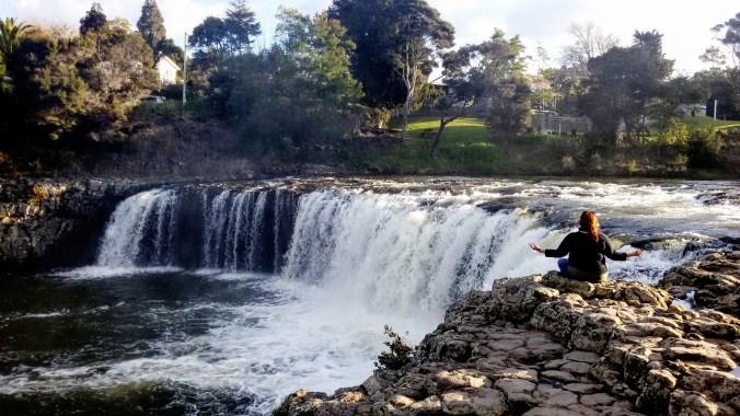 Waterfalls are a rare occurrence in my life but I treasure them. I ended up climbing out on the rocks to get close and then just sitting and breathing it in. There’s some kind of chemistry that happens to air that’s churned in a waterfall and it makes us feel better, happier (negative ions, no really, look it up). There was a trail along the river, but I’d had a full day of


 The park service in New Zealand hasn’t really mastered the loop trail and this was no exception. The trail led up to a single point and returned along the exact same route. It was marked by the occasional tiny orange triangle nailed to a tree and for a while I felt like an intrepid explorer in Middle Earth. The forest was deep and green and dotted around with huge rocks that looked like nothing so much as Bilbo’s trolls turned to stone and broken down. I even found one that looked like a giant stone foot! Other places the rocks became less like the remains of curving carved statues and more like the square blocks of a fallen castle or fort, like the ruins of Cair Paravel. Of course, all the rocks are natural formations from glaciers, but it was fun to imagine. This part of the hike is the easiest and quite possibly the lovliest. If you’re here for a short visit, I’d say it’s worth it to walk as far as the bridge, at least.
 Beyond the bridge the landscape changed. The rocks all but vanished and the type of plants completely altered. Now instead of lush green trees there were scraggly gray thorn bushes taller than me that were growing their first bright yellow spring flowers. This let out into another forest, but much more jungle/rainforest in theme than the boulder-filled fantasy below. There was a stretch of farmland too, which I thought may have heralded the end of the trail as it led onto a nice little grassy terrace with a view all the way to the ocean, and a little wooden bench to sit and rest. This bench would be my second recommendation for turning around if you’re getting tired.
  The view is nearly as good here as it is at the top, so unless you’re an achievement junkie like me and just need to say you got there, it’s a fine place to end the hike.
  I came across a goat on the path with her baby. They were both snowy white and I stopped to watch them for a while before they crashed off into the undergrowth. I hadn’t seen any goat farms around, just sheep and cows so I wondered if she belonged to someone or if her ancestors had escaped captivity, and now she and her kin roamed the park lands wild. After much muddy trudging, I emerged into daylight again only to be greeted with a fence and a businesslike sign advising me that I had reached the end of the trail and should now turn around. No monument, no viewing platform, just this electric fence and sign. The sign informs visitors that they are welcome to admire the view from the property line, but to be cautious as the fence is live. Ok then. It was a nice view, but there was not much room to move around and nowhere to rest, so I soon headed back down the hilly mountainside to find the bench I’d left behind.

 I’ve wanted to swim with dolphins since the very first time I went into a marine park and saw the trainers interacting with them. If we hadn’t left Florida, I may have pursued a career as a marine biologist and/or dolphin trainer. Alas, my years in Tennessee squished that childhood dream like a bug on an 18-wheeler. Since then, I have learned the damage that dolphins suffer in captivity and no longer support marine parks with captive large mammals, which might be all of them. I do still go to zoos and aquariums. There are good reasons to have those things, not the least is that it engages children early and makes people interested in and concerned about animals in the wild and wilderness conservation. However, I couldn’t bring myself to pay a marine park for the privilege of swimming with captive dolphins whose lives are unfairly shortened by that captivity. Thus, when I found this option, this swimming with wild dolphins in the ocean option, I was hooked.
 This is not as easy as it sounds. I had booked a room in a different location nearly every night for my trip. I wanted to be able to wake up near my day’s activities, enjoy them, then in the evenings when the sunlight went away and the temperatures dropped drive to my next destination. I’d booked a room in Piahia for Monday night, with the hopes of boating on Tuesday. I watched the weather like a hawk and emailed back and forth trying to determine the ideal conditions. On Sunday, the weather showed Monday to be rainy, but Tuesday and Wednesday seemed to be nearly identically perfect. I’d booked rooms in the north peninsula for Sunday, Monday and Tuesday night, each about an hour from the other because the peninsula isn’t that wide. So I had a little latitude if I was willing to do the extra driving, to rearrange my day activities Monday, Tuesday and Wednesday. However, Wednesday night, I had a prepaid cabin at Hot Water Beach that I couldn’t move or cancel and that was a 4.5 hr drive back through Auckland and up the Coromandel Peninsula.

 I sat up on the very top and began (as I do) chatting with another lone traveler until the skipper asked all those interested in swimming to come to the cabin below for a safety talk. If/when they sighted dolphins, we would have very little time to get changed and jump in, so they wanted to give us the talk as early as possible. We filled out our health and indemnity forms and then listened to the safety regulations about not touching the dolphins, about the possibility of cold shock and hyperventilation in the water, and about how to wear a snorkel. Just as she was finishing up, the skipper announced a dolphin sighting. Our safety class all but disintegrated as everyone rushed to the doors and windows to see. Only threat of not being allowed in the water brought them back.
 As we were watching the dolphins swim around, the skipper announced they were feeding and we wouldn’t be able to go in the water after all. So I settled in to take some pictures and watch them play. I was amazed at how close to the boat they came. They swam around us, not just little fins in the distance, but just below the surface of the water alongside the rail. The skipper was identifying those of the pod she could by their dorsal fin shapes, as each dolphin’s fin is as unique as a fingerprint, and I’d only taken a few photos when suddenly the call came to change into our diving gear now, now, now.
 As we rode out to “the Hole in the Rock”, we passed by dozens of tiny islands, some inhabited and some not. We were regaled with histories of piracy and assassination in the early days of European settlement, and of the farmers who later raised dairy cows around the islands which resulted in the need for a “cream run” boat to collect the milk and how that later became the first boat to run tourists around the bay as well and was the ancestor of the company boat we were currently on. The hole in the rock island has significance to the local Maori tribe and is still held in trust for them, although it is preserved as a wildlife refuge because it has no evidence of being exposed to external plant or animal life. We didn’t go on to the island because the boat tours don’t have an agreement with the Maori there, but we did sail out to take a look at the unique natural rock formation. When the weather permits, the boat will go through the hole, but the winds were too high so far out of the shelter of the Bay, and the skipper decided it wasn’t safe. Personally, I didn’t mind. If the weather had to pick only one thing to be cooperative about that day, I was in support of the swimming over sailing through a rock.


 Staying as long as we dared, we scampered back down the hill just as the boat was sounding the 10 minute warning and we passed the only other passenger ship on our way out. During a lingering view of a close pair of islands, we spotted dolphins again. The same pod we had swum with earlier came back for another peek at the boat. The restrictions on swimming time meant we couldn’t go back in again, but this time I had more of a chance to watch them from the deck and snap a few more photos before they left us for the last time and we began our travel back in earnest. In opposition to some of our leisurely boating around the islands, we had a speedy return to the ports where we had two options for the afternoon: Piahia or Russell.


