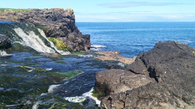
Northern Ireland is stunning. I was incredibly lucky to have very nice weather on the days we were exploring the country and the coast, but I can’t imagine it is any less stunning when it’s cloudy and ominous than when it’s sunny and blue and you can see Scotland from the cliffs. This isn’t only wild, untamed scenery. It includes some ruins which have begun to merge with the landscape and some cultivated gardens that show the lovely flowers to their best advantage. In the tradition of saving the best for last, you have to wait till the end to see the Giant’s Causeway.
In Between
There are places in Ireland that everyone wants to go to, me too, but driving from one of those to the next could mean endless hours of highways OR it could mean tiny back roads and mini stop offs to lesser known, but still beautiful sights. Guess which one I chose? Here are a few of the in between places that were added to the itinerary purely because we wanted somewhere to stop between points A and B.
Grianan of Aileach
I almost forgot about this stop. For shame. It was a bit of an afterthought on the day we visited as well. On the road between the Belleek Pottery factory and the city of Derry, we drove up a little side road to find this ring fort. The view from the top is breathtaking, and it’s just my type of mountain top that you can drive up and park on top! There were not too many other people out, but there was a small cafe style food truck hoping to sell some refreshments. There’s no toilet facilities however, so we declined.
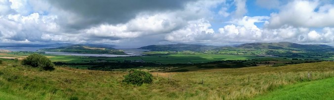
The fort was built in the late 700s-early 800s, raided by Vikings in the early 900s, and finally destroyed around 1100. The restoration project started in 1870 and is protected and maintained by the Office of Public Works today. It’s one of many tiny little treasures that make driving a much more appealing option to bus tours. We only spent about 15 minutes at the fort, just long enough to gasp at the view and enjoy the archaeology.

Glenarm & Glenarife
These two stops were along the west coast of Northern Ireland, after we finished the Causeway and before we arrived in Belfast. Glenarm is a beautiful castle estate (not a ruin) with cultivated walled gardens. Genarife is a beautiful forest hike with a waterfall.
Glenarm Castle is related to Dunluce Castle, a ruin located on the Causeway Coast which I’ll get to that later in the post. The story goes that in 1639 as the McDonnell family were waiting for dinner one evening at Dunluce, the kitchen – along with kitchen staff – fell into the sea. After that, the family commissioned a new castle to be built on their land at Glenarm which was finally completed some 80 years later. Viscount and Viscountess Dunluce and their family still live there today. Tours are offered of the public portions of the castle, usually between 12-4pm (although the website gives a lot of COVID closure warnings these days).
While I’m sure the inside of the castle is stunning, we were much more interested in the walled garden on our visit and so I can’t tell you anything else about the home. The garden is well worth the visit, however. It is one of Ireland’s oldest walled gardens and it is impeccably maintained. There are dozens and dozens of beautiful examples of flowers, fruits and vegetables, a lovely miniature maze, a small “mountain”, and multiple lovely statues placed throughout.
The afternoon we visited was quite gray and rainy. We were forced to wear our outer shoe rain booties and carry around umbrellas, but I personally think that raindrops on flowers make for beautiful scenery (and photos) so I wasn’t too upset.
Sidenote: We lost MS Video Maker, then YouTube Video Editor and now Google Photos has decided to make the photo slide shows vertical for some unholy reason, I had to go find a quick and dirty way to make a slideshow. I’m sorry that the quality is a little rough. If one of the hip people could clue me in on what we’re all using these days, I’d really appreciate it.
Glenarife was a bit of a back track for us on the road trip, but we had made the decision to go there second so we could have dinner at the restaurant inside the park. I plan to write a separate post about the food in Ireland, but I want to stress that planning meals on any vacation is really important, but especially on a road trip through the countryside. If you’re staying in a city, it can be easy to just head down any major street and walk into any restaurant that looks interesting. If you’re driving (or busing) around, then taking time to find where there are restaurants and WHEN THEY ARE OPEN can save you a lot of heartache and petrol station snack meals.
There is not a lot in the way of eateries on this particular stretch of the Irish coastline, so when I found the Laragh Lodge attached to a waterfall I was excited to get two birds with one parking lot, so to speak. We arrived at the Lodge around dinner time and were quite surprised to find the place very full. They had a wedding party in. Thankfully, there was a dining room off to the side for the general public, so we could still eat there. Because the day was drawing to a close, we decided to go on our waterfall walk before dinner. Same gray rainy day, still, but the raindrops had mostly stopped.
The trail leads a over a little creek which looked like it was made of Guinness, and up a slight hill. It’s a short walk from the parking lot to the falls. There are longer hikes around the enormous forest park for those who want to spend more time in the great outdoors. I personally was there for the waterfall and the food.
When you look up the Glenarife falls online or go to their website, you see pictures of a pretty little fall with usually 2-3 streams down the broad rock face. When I was there, it had been raining. A lot. No cute trickle of water, not even a stout fall, no — that day, the torrent could be used to power a whole hydroelectric station. Waterfalls release negative ions, which reduce depression and stimulate the brain and body. I know sounds kind of like pseudo-science bunk, but it’s been tested I swear! #waterfallinlove
One Day on the Causeway Coast
The Giant’s Causeway may be the most popular thing on the north coast, but it’s far from the only one. We spent an entire day from dawn to dusk travelling the Causeway Road, visiting both it’s famous and less well known attractions. Technically the Coastal Route extends from Derry to Belfast and would therefore include my stops at Downhill Demesne, Bushmills, and Glenarm, but I am focusing on those parts most immediately surrounding the Giant’s Causeway itself.
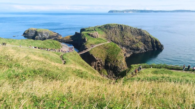
Carrick a Rede
The rope bride of Carrick a Rede is often included on a tour of the Giant’s Causeway. After my initial research about things like parking and ticket times, we decided that the best way to do the bridge was very first thing in the morning. There is a parking lot near (1km) from the bridge access, but it’s small and fills up fast. Alternate parking is, of course, farther away. In addition, you must buy tickets in advance and reserve a ticket time. If you miss your window, then you don’t get to go. The bridge can only accommodate so many people at once, so the staff on site work hard to make sure everyone can have a good and safe experience. Weather is also important. As you may have seen in my Aran Islands post, the Irish weather on the coast is extremely fickle, and tourists aren’t able to enter the bridge if the weather makes conditions unsafe.
I was so happy that our weather was clear and blue. We showed up to the parking lot with plenty of time to walk. We had no trouble parking since we were in the first group. There was a little confusion at the ticket booth, a little bottle neck where we all clustered together waiting for them to let us in already! The other advantage to early morning tickets is that the tour buses almost never show up that early, so those of us who had made this effort really wanted to get the jump.
Finally, our e-tickets were scanned and we started the hike from the gate to the bridge. It’s not a hard hike, but there is an upward incline and many stairs. The great news is that the whole path walks along the cliffs and so you spend the hike up with the view to your left, and the hike down with the view to your right. Almost all the photos I took were on the way back down since we were in a hurry going up.
The bridge was built by salmon fishermen way back in the day because the little volcanic island had much better fishing than the mainland. The bridge today is purely a tourist attraction, but you can see the remains of the small fishing “village” on the island after you cross. There is a gate at the point where the trail meets the bridge manned by park staff who ensure that the safety measures are followed and to help people who may be nervous. The narrow (one person wide) rope and plank bridge is 100 ft above the sea and sways and wobbles as you walk on it. It is recommended that you and your travel buddies take pictures with the camera holder on solid ground while the other poses on the bridge. There’s no time for perfect Instagram poses, though, because while the staff will let you take a couple snaps, they urge everyone to keep going. Being so narrow, the bridge cannot accommodate cross traffic, and so a small group goes to the island, then when the bridge is clear a small group returns.

")
I could have spent the whole day on the beautiful little island. It was just such perfect weather and the grass was soft and fresh. I took a small infinity of photos of the sea and the sky, as well as the little flowers and volcanic rocks. It was only with great reluctance that I finally left to get to the next stops on the day’s itinerary.


I found a slightly alternate route back that took me up a little farther and gave some spectacular views down onto the path and island, and I positively delighted in the tiny flowers and busy bees along the cliff-side path on the way back down.
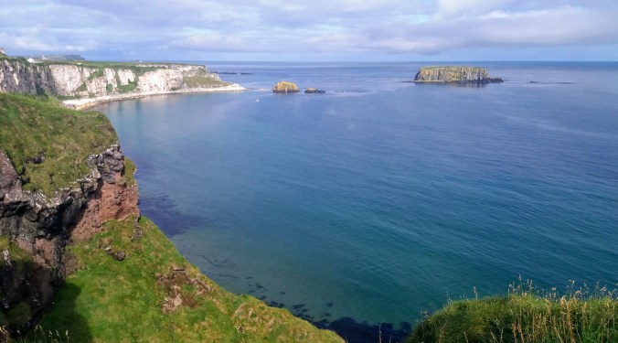
Dunseverick Castle & Falls
Along the Causeway Road are a large number of small sights. The rope bridge and the Giant’s Causeway are the main stops on every tourist bus tour, and in order to avoid those crowds, we decided to spend the prime tourism hours going to the smaller locales. The first one of these as we drove westward was Dunseverick Castle and Falls. What? Castle ruins and waterfalls? in one place? Twist my arm.
Dunseverick has been a seat of power in Ireland from the 400s! It was a ring fort for a bit, and supposedly visited by St. Patrick himself. Invaded by Vikings, and contested by clans, it was owned by the O’Cahan (anglicized as McCain or O’Kane) family until it was destroyed by CROMWELL (ugh, that guy again) in 1642. All that remains of the castle is the ruins of the gate lodge.
There’s a long walking trail that also runs alongside the cliffs which some people choose to hike, and you can access the ruins this way. I was not particularly interested in the route from parking spot to ruin, but the falls looked decently close, so I hopped a stile and headed off through the nettles to find a waterfall. It’s not as bad as it sounds. Stiles are meant to be hopped, they’re just ways to step over fences that humans can do but animals can’t. Also, nettles only hurt you if you grab them (which I didn’t) or fall on them (which I did, ouch).
Nonetheless, the day persisted in being superb and I found the low and wide falls amid the dark brown and black volcanic rock. I don’t think I’ve ever seen falls along the seaside, so while they were a bit short, they made up for that by being unique.
Bushfoot Beach
There are a few “beaches” along the coast as well, but not especially the kind you think of for sandcastles or bathing. We looked for Runkerry Beach, but I wasn’t able to figure out how to get the car there. Bushfoot Beach was adjacent to a golf club so we parked there and meandered down to have a look. It was small, and cute, with a nice bench to sit on and rest. Locals were out walking dogs along the path, and there was a river that came down and flowed into the sea right where we were. It wasn’t a highlight, but it was a beautiful and quiet place to have a little rest before the next stop.

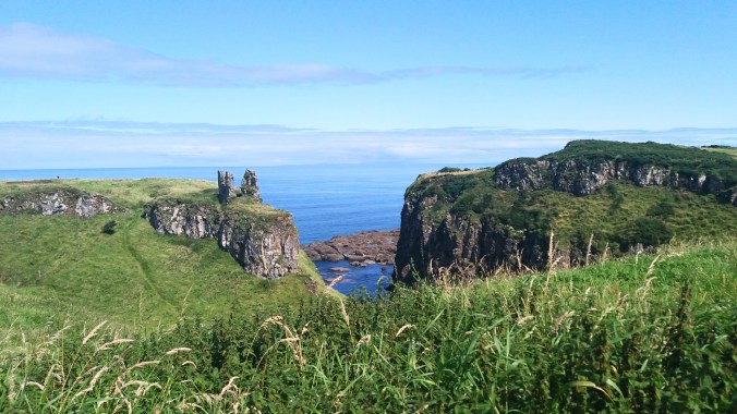
Dunluce Castle
Sound familiar? Yeah! This is the same Dunluce castle that dropped it’s kitchen and staff into the sea, prompting the McDonnells to move to Glenarm. The McDonnells are not actually Irish, they’re Scottish originally.

In case it wasn’t abundantly clear by now, I am an absolute sucker for ruins. Literally, if I could take a vacation that was made of waterfalls and ruins with a few good restaurants, I would be in heaven. I try to look up the history and learn things about the ruins I visit. They often have fascinating secrets or at least interesting stories. In the case of Dunluce, the kitchen staff falling into the sea might be the most interesting thing that ever happened to it until it was used by Led Zeplin as album art.
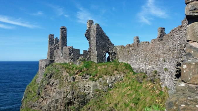
There were some very informative signs on site, showing artist renditions of what the house and grounds may have looked like when it was alive, and there’s a very dry Wikipedia article about the Earls and the invasions. I could recite that for you, but why? A far more amusing resource is this Belfast Telegraph article. Otherwise, please enjoy the photos!
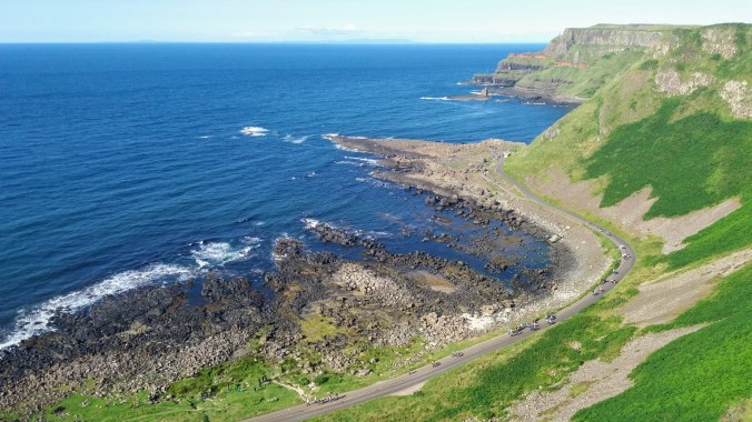
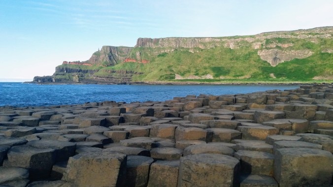
Giants Causeway
This is what we’re here for right? If you’ve come all the way to the tippy top of Northern Ireland you are here for THIS and everything else is pretty much frosting and sprinkles. Don’t get me wrong, everything else was wonderful, and I’m extremely grateful that I had the chance to drive myself around to the variety of stops. If you can’t rent a car or don’t want to drive on the left, there are tour buses that go to Carrick-a-Rede, Dunluce, and the Giant’s Causeway in a day, but after having done a driving tour and a bus tour (later) I have to say that driving in Ireland is (mostly) very easy and pleasant and having the freedom is well worth it.
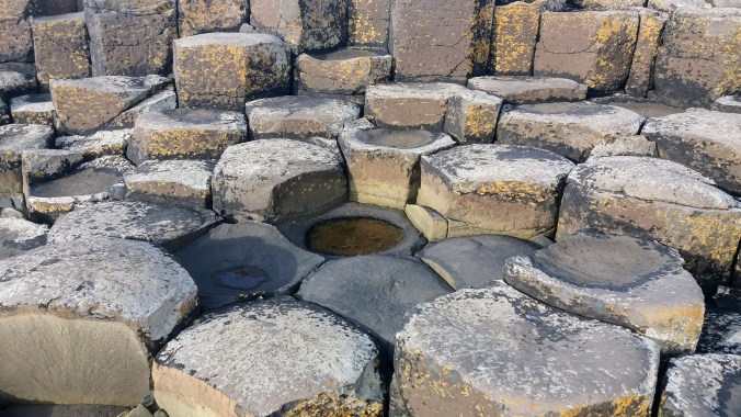
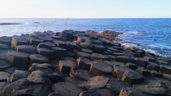
The Giant’s Causeway is a totally unique geographical formation of honeycomb-like stones reaching from the base of high grassy cliffs out into the sea. These formations are called basalt columns, and are made by lava cooling. As a not-geologist, I can’t really understand, let alone explain why some lava makes pumice, and some makes lava tubes, and some makes these cool hexagonal shapes, but I trust that there are geologists who can. The short and easy version is that something in the molecular makeup of basalt causes it to form cracks in these shapes when it cools rapidly. Probably why these formations are almost always found near water.

Although the Giant’s Causeway is by far the most famous, there are many other examples of basalt columns around the world, so you can still see them even if you don’t make it here. I was most fascinated to see there’s one here in Korea, on Jeju Island, that looks like a tiny version of the one in Ireland. It’s not a popular tourist attraction yet, so my tour didn’t go there when I visited Jeju several years ago. I’ll look for it if I ever go back.
Today we understand the science behind these fascinating formations, but when humans first came into the area, they incorporated the stones into the mythology of Ireland. I talked briefly about the pre-history mythology in my Two Irelands post. The beginning of Ireland was fraught with many races of monsters, giants, gods, and fairies, each one supplanted by the next. The 5th race was the Tuatha Dé Danann (from which almost all modern fairies seem to be descended), and the 6th and final were the humans. The stories of Finn McCool (Fionn mac Cumhaill) seem to be set toward the beginning of the humans arrival into Ireland since he fights with giants and at least one of the Tuatha Dé Danann.
The myth, like all myths, is tricky, and not every source agrees on the details. Most of us are more familiar with the Arthurian legends, and as anyone who has tried to sort out the details knows, it’s not possible. So, I’m presenting a vague and “best guess” version of Finn McCool here.

He was born into if not actual royalty, then the next best thing. His father’s clan was said to be descendants of the Fir Bolg (the 4th race) and his mother was recorded as a granddaughter of the Tuatha Dé Danann. Finn himself became the leader of the Fianna, a kind of warrior band, and had all kinds of fantastic feats attributed to him. You can’t go anywhere in Ireland without finding some piece of local Finn legend. According to the most popular stories, he (like Arthur) is not dead, but merely sleeping in a secret cave and will return in Ireland’s greatest hour of need.
When it comes to the Giant’s Causeway, there are still a few versions of the tale, but the most common involves a Giant named Benadonner. Benadonner was a fierce Scottish warrior and a giant (one of the races previously driven from Ireland). One day Finn challenged him to a fight, but the giant didn’t want to cross from Scotland and made excuses about the sea as an obstacle.
Finn then built a bridge between Ireland and Scotland. This is one of the closest points between Ireland and Scotland, only about 28 miles to the nearest Scottish peninsula. When the bridge was complete, Finn sent a message to Benadonner that he had no more excuses, so come along and fight me!
 However, when Finn saw Benadonner crossing, he realized the giant was much bigger than he previously thought. He fled the coast, retreating into his home. His wife Sadhbh (omg Gaelic, amirite?, that’s probably pronounced “Saive”, maybe?) heard what he’d done and quickly dressed her husband up as a baby.
When Benadonner came to find him, he saw the disguised Finn alone in the house and thought to himself, “If this is the infant, what must the father be like?”, and quickly fled back to Scotland, tearing up the bridge in his haste, leaving only the remnants at either end: The Giant’s Causeway in Ireland, and Fingal’s Cave on the Scottish Isle of Staffa, named for Finn himself. (Although the nearest point is only 28 miles from the Causeway in Ireland, Fingal’s Cave is 82.5 miles as the giant flees).
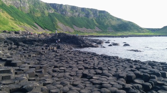
Whether you are drawn to the science or the more whimsical heroic tale, there’s no doubt that the natural beauty of the Causeway is breathtaking. We scheduled 4 hours for it and that was barely enough. It’s a hard choice to make as far as what to see in a single day. If I had it to do over, I might have scheduled one day for just the Causeway, and a second day for all the other stops. We planned to arrive around 3pm so that we would be walking in about the time that most of the tour buses were walking out.
I found some shuttle bus information online, but it turned out not to be as accurate as I’d hoped and in the end, we decided that paying for parking at the visitors center was going to be better for us convenience-wise than trying to take the shuttle bus from Bushmills, and honestly only slightly more expensive. If you happen to have a National Trust membership or possibly even a tourist pass, you can get steep discounts on things like the shuttles, the parking and the entry tickets (many are free included), and I also looked into buying that, but since only Northern Ireland is run by the UK National Trust, we just weren’t going to go to enough places to make pass worthwhile. If I were to plan a trip that included even one more day in the UK, I think it would have been.

The parking lot is enormous and the walkways funnel tourists to the Visitor’s Center. You don’t have to go there. The outdoor parts of the park are FREE (after you pay for parking or the shuttle bus) and the visitor’s center is like 13£. I opted to spend my time and money seeing the sights in person, but I can see if you perhaps had bad weather, the visitor’s center might be appealing.
Another travel blogger advised me to take the red trail from the Visitor’s Center to the Causeway. There is a main road (paved wide road) that goes very directly. People who are in a hurry may use this, and there is another shuttle bus that runs between the Causeway and the Visitor’s center which I think is very nice for those with limited walking ability. However, the red trail leads up along the cliff tops before descending to the sea, and it has some really stunning views. It’s much easier to walk it going down than going up, so starting on the red trail and then using the wide seaside road to return seemed the way to go.


The main trail starts by going through a tunnel near the visitor’s center, while the red trail starts before the tunnel and off to one side. There are signs. It is marked as a more demanding route, but that is only in comparison to the smooth wide paved main path. It’s about a mile (UK, back to imperial not metric!) and there are maybe 100 stairs going down. I thought we could take the shuttle bus back up, but that stops running when the visitor’s center closes at 4pm, so if you are mobility limited, make sure you plan your visit earlier in the day that I did.
The red trail is not for those afraid of heights. It goes along the edge and has some harrowing narrow paths and steep steps on the climb down. I thoroughly enjoyed the walk which included yet more stunning cliff-side views, a million tiny flowers and the little bugs that live in them (one of my favorite subject for photography), and a chance to see the organ pipes formation and the giant’s boot on the way down (something those who take the main path would have to climb up to see).


It was charming to see the tourists delighting in hopping from rock to rock like a childhood game of hopscotch. I climbed as far out to the edge as I could, marveling at the geometrical patterns and the tiny lichens and barnacles living there.


Finally, as dusk loomed, we headed back up the road, enjoying the tide pools and sunset over the water. There’s no doubt in my mind that the Giant’s Causeway is the jewel in the crown of Northern Ireland’s natural beauty and I’m grateful that I was able to experience it on such a beautiful day.


 We are working to help the villages develop systems for chronic disease management, such as having a monthly day where a doctor visits from the regional center to provide care for people with chronic conditions. If we can get funding toward it, this could become a celebratory day with a meal provided to encourage people to attend. Hopefully some of these changes will help people stay healthier.
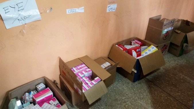
 We moved to another village called Otuam. Their health facility was much smaller and patients had to wait outside under tents to be seen. I worked with Dr. Cornelius, testing for malaria and checking blood sugar. In Ghana, Malaria is seen more as a nuisance than a life-threatening sickness. It’s similar to the way people in America relate to the flu. The flu occasionally kills people in the US, but most of us expect to get it at some point. Since we were already on malaria prophylaxis (vaccine), I followed their lead and have been mostly skipping insect repellent. Amazingly I haven’t gotten a single bite all week.


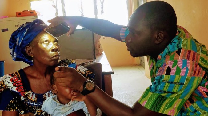
 This hospital is rare and unique in Ghana. It has a special team to manage chronic conditions like diabetes and hypertension. We spent some time talking to their director and making plans to work together over the next year to bring their amazing work to more communities. We are also going to try to get them additional funding for important equipment they need, such as the ability to test HbA1c levels (a diabetes blood sugar test). We were able to tour the hospital and were overjoyed to find that, unlike the rural village clinics, they kept medical records and charts on their patients. I’m excited to see teams in Ghana working to initiate chronic condition management and hope other hospitals are inspired by their work.
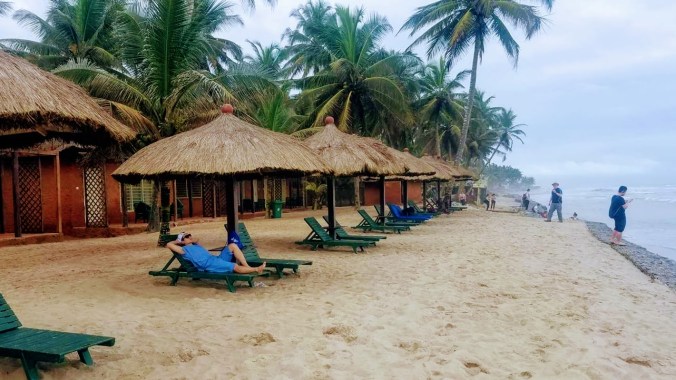 On the way home from the hospital we took some time to relax at one of the local beaches. It was incredibly beautiful, but parts were covered in litter and we were told the water wasn’t clean enough to swim in. It was nice to listen to the sound of the waves and rest in a place with a cool breeze. Such a lovely day.


 Cape Coast Castle was a trade fortress that was converted for use to house and break the spirit of slaves before they were loaded onto boats. Our visit began wandering around the open air area and looking at the canons over the sea, then into a museum detailing the history of the castle and its role in the slave trade. When I was about halfway through the museum our guide collected us for a tour of the dungeons where the people who were to be slaves were imprisoned.
 To give us a glimpse of the fear they must have felt, he had us initially descend in complete darkness, only turning on lights once we had reached the stone wall on the other side of the male dungeon. He explained that this small underground space held up to a thousand men for months at a time. They were forced into complete darkness where they had to live in their own filth and excrement, packed against their brothers. The floor we were standing on was false, built on top of the human waste that had accumulated there.
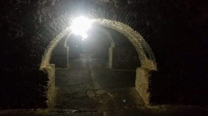 To add insult, directly above the slave dungeons where people endlessly suffered was a Christian church. Our guide described the thought process that many slaves went through when they decided to convert to Christianity. To a person experiencing such agony, it would seem like your God had abandoned you or was weak, yet those who followed the Christian faith were clean and happy, prospering above. It must have appeared to many that the Christan god was stronger or better to his worshippers.
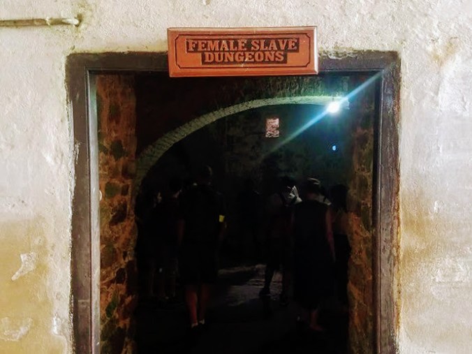 The women’s cells were similar to the men’s, except that their door was regularly opened so they could be grabbed and raped at will. Sometimes they were bathed before this occurred, and other times drunk soldiers would not even afford them that decency. Women who resisted were beaten or put into a hotter cell where they were locked without food and water and often died if their spirits weren’t quickly broken. Our guide shut us into the boiling confinement cell for about 30 seconds, which was enough to have some of us panicking.

 We were left with a plea to remember that slavery is not gone from this world. People are still taken against their will and forced into terrible suffering and servitude. He asked us to see, to take a stand, and to remember.
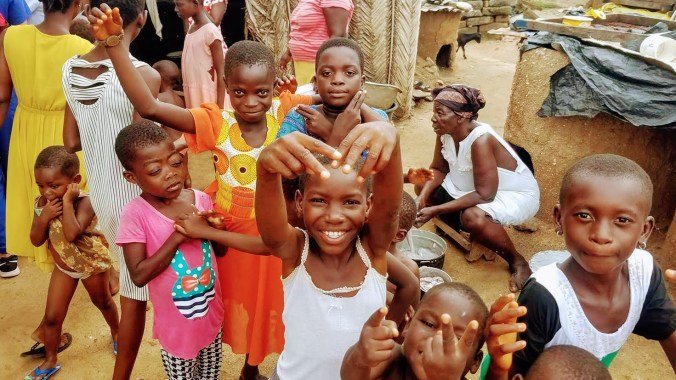
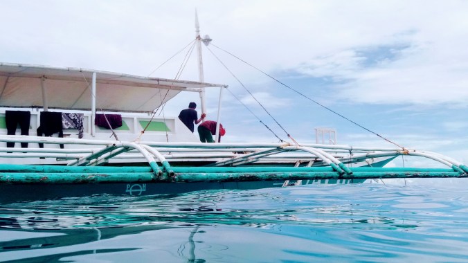
 Regardless of who you choose to go with, make sure you ask about any extra fees for Balicasag. Some activities do require paying the national park fee and others don’t. It’s never fun to be caught by surprise once your in the ocean. Valm Dive wasn’t planning to go to any of the pay areas, and so we were only on the hook for our ride and equipment (mask and snorkel only, no fins. I think they would have let us use them if they had extra, but they had to supply the divers first and ran out). Total cost: 500p or about 10$ USD.
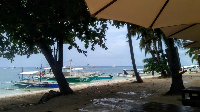 That morning was one of the few rains that happened during our active times. On any other morning, we could have just waited for it to stop, but Rafi had told us to be at the dive shop at 8:30 and we didn’t want to be late and run the risk of losing our spot on the boat. We waited as long as possible, and it didn’t take long for the downpour to become a drizzle. Driving on the wet roads wasn’t nearly as difficult as I feared, but getting a face full of rain made seeing a little challenging. I thought again about what kind of gear to use to prevent that if I ever had to drive a real distance in the rain, but it seemed like all the locals, in addition to shunning helmets, only wore ponchos while driving in the rain, leaving their faces, and eyes, open to the wet.
 The Wall
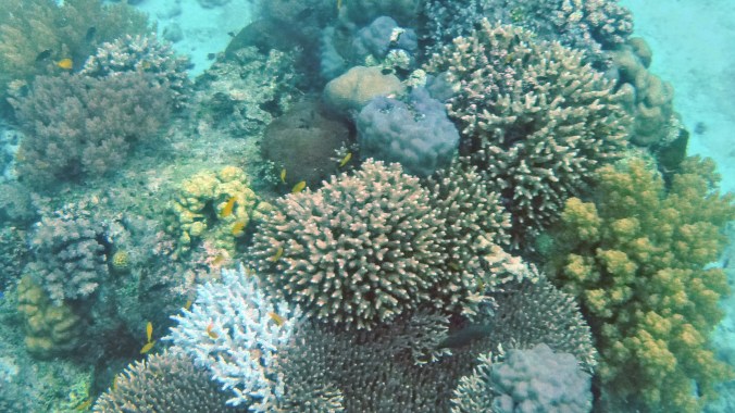 The corals were lovely, and I wasn’t in a hurry to get anywhere in particular. It was my first real chance to play around with my new underwater photo taking capability. Almost as soon as we got in the water, I spotted my first turtle hugging the edge of the drop off. I did my best to keep pace with him, but especially swimming against the current, I had no real hope of catching up to a turtle, no matter how lazily he seemed to be swimming. Finally, I had to give up. I swam using as little energy as possible, but it was hard going because the current was much stronger than I was used to and it was impossible to hold still while taking a picture.
 I wove back and forth above the stunning coral shapes, trying to get my camera to focus when I was spotted by a little rainbow wrasse, maybe 5 inches long. It was clearly watching me, swimming back and forth in front of me in quick zipping lines, and once it was sure it had my attention too, it swam straight at my face. I was honestly worried it was going to hit my mask, not for my safety, it was a small harmless fish, but worried that it might hurt itself bashing into the plastic. Fortunately at the last moment it turned aside.
 It seemed like a strange behavioral anomaly, but the fish came back and did it several more times. As I got used to the pattern I tried to get a picture. I wish I could have done a video, but I hadn’t quite figured out the trick I needed for that with the waterproof cover.

 We set off from Busan (blue dot) in the morning to drive all the way across the southern end of the Korean peninsula to Jindo (red dot). Although Korea is small compared to, say, the US, it was still almost 5 hours of driving with the occasional pit stop. (By the way, in case you’re curious, you can see Daegu on this map as well). Fortunately, I went with a tour group (my stand by
  The Jindo festival had at least one feature I’ve never seen before: a traditional Korean wrestling ring. A pile of sand was placed in a large circle where two contestants could wrestle in the traditional style.
  Even more bizarrely, after the color throwing was over, the festival organizers gave each participant a “toga” to wear. The togas were long white robes with red sashes that could have evoked a Roman senate or Jesus. Considering we were about to “part the seas” it was hard not to see it with Judeo-Christian overtones, but the rather drunk person I asked about it just said “toga party!” The entire thing seemed like the festival organizers were trying to find a way to appeal to the expat crowd. I’m glad they had fun, but I would have preferred some more traditional activities, like someone to teach us about collecting clams and seaweed the way the locals were doing as the tide went out. It’s hard to go do local culture festivals when the locals are busy trying to white-wash everything for cash.
 Finally, the real “reason for the season” was upon us and we muddled our way down the road to the rainbow steps beneath the watchful eye of the grandmother and the tiger. We paused at a bench to don our thigh high rubber boots and got some advice from the locals on how to attach the rubber garters through belt loops to hold up the boots, or failing that, to wrap them tight around our thighs and snap them in place. Thus clad in bright orange and yellow wellies, we made our way down the steps and into the shallow tide pools to wait for the tide to recede.
 If you look at the area on Google Maps you will simply see the beach and the islands, but on Korea’s own Naver Maps, there is a thin line connecting the rainbow steps to the island of Modo. Although this path is only usable twice a year (at most), the Korean map makers consider it important enough to draw in.
 The history of tidal prediction starts with Kepler (total nobody) in 1609 to theorize that the moon’s gravity caused the ocean tides. He was followed by other such no-ones as Galileo and Newton. It was in 1776 that the first big complex equations came from a man called Laplace. Harmonic analysis was added in the 1860s and polished off by 1921 in the form that Navies all over the world still use today. Although the math hasn’t changed in almost a hundred years, computers make the math easier and the information more widespread so now instead of just ships in harbor– surfers, beachcombers, and clam hunters can
  On a more mystical note, the local legend of the tigers explains why there’s a statue of a grandmother and a tiger overlooking the sea. Long long ago, the villagers who lived on Jindo were plagued by man-eating tigers. The whole village packed up and sailed over to the neighboring island of Modo to escape the threat, but one woman was left behind. The woman was Grandmother Bbyong, and she prayed to the Dragon King, the god of the sea, to help her. Finally the Dragon King came to her in a dream and told her he would build a rainbow brigde across the sea for her. The next day when Bbyong went down to the sea, the waters parted to let her cross and her family came out from Modo to meet her. This also explains the rainbow stairs that lead down to the landbridge, but not why her family couldn’t have just sailed back for her in the first place.
 While math can now easily tell us the time of the lowest tides, it does not yet advance to tell us what the actual lowest level of the water will be. Not that it couldn’t, but there are more variables involved, so it’s not a thing now. While we can say with certainty, the lowest tide of the year on this beach will occur at 18:38 on April 29 (or whatever), we can’t say for sure if that will expose the land bridge or simply be lower than every other tide around it.
 We tromped along the path, watching parasailers overhead and rainbow colored lanterns being released in to the air from the beach behind us. It was clear the path was quite narrow because going too far from the group to one side or the other to get a picture resulted in a severe deepening of water level. At the time, my friends and I theorized it might be man-made, or at least man-maintained, however, I have since then found that the build up of rock and sand in this twisty line is a natural result of the currents around the islands.
 Before long the golden light of the sunset combined with the swish-swishing of hundreds of feet through water to create a trance-like state. I could not judge how far the island was, nor tell which way the path twisted. The rocks below us rose and fell, bringing the waves treacherously close to the top of my boots and then back down to barely splash over my toes. The whole path is nearly 3km long. I suspect a determined person could make it out to the island and back in the hour or so the path is clear to walk, but I wasn’t racing, and soon we were greeted by the sounds of Korean drums and the distant flags waving as the procession from Modo came out to greet us.
 The walk outward had been slow, trepedatious, as though we were nervous the land could drop away at any moment, but the trip back was much more celebratory as well as much more damp. The parade of drum bangers, cymbal crashers, gong ringers and flag bearers danced merrily in their traditional garb, urging us all back to the larger island of Jindo. Our pace quickened and our legs swung to the rhythm causing much larger splashes. Waves came in from both sides of the path making us nervous, but excited. The water finally breached the top of my boots and sent an icy chill down my shins, but I found I did not mind.
 Before heading to the fields, we walked up a long road past the area of the light festival where a few wire frames from reindeer and dragons could still be seen. The road up the hill was painted with fun perspective illustrations of a stream, complete with little camera icons to show the best places to stand to see the visual effect. Optical illusions are fun.
 At the top of the hill, far beyond the little pagoda that had marked the highest point of the lights, we finally came upon the green tea museum where we were treated to a special showing of the Korean green tea ceremony (complete with English translation by our awesome guide). The ceremony involves a process of several containers: a water pot, a cooling bowl, a tea pot, and the drinking cup. The hot water pot is filled with boiling water, which is then poured into the bowl, and from the bowl into the tea pot and finally into the cups. The instruments are warmed up in this way. Then more boiling water is poured into the cooling bowl. Tea leaves are scooped into the warm but empty tea pot and the ideal temperature water is poured from the bowl over the leaves. While the tea steeps, each cup is emptied of it’s hot water into another bowl on the floor and wiped dry on the outside. The tea is then poured into the pre-warmed cups by pouring only a half a portion into each and the other half in reverse order on the way back. The tea is then served, 4 cups to the guest and one to the host.
 The hostess tried to tell us a bit about green tea, red tea and black tea but her translated explainations seemed off to me, since she said it had to do with the age of the leaf when it was picked from the plant. I don’t know if this was her or the translation, but the real story follows: In any country with Chinese roots in it’s culture and language, the three colors of tea are a bit different in meaning that in the West. Red tea is not Rooibos, in fact all three come from the same plant. And it’s not the age of the leaf at picking that determines the difference, but rather the post picking, pre-drying process. (although especially young and tender tea leaves are sometimes referred to as “monkey picked” and do make a delightful tea).
 After we conducted our own tea ceremonies, I drifted lazily back down the hill, examining the spring flowers and the grounds that had been lit up beautifully last December. When I finally got back to the tea fields, I took off on the same route I’d walked before and was happily greeted by many blooming apple trees and a small army of busy bees who were so focused on the brief blossoms that they paid no mind to all the humans fussing around. In fact, I think it was the only time I’ve seen Koreans in the presence of a bee not totally freaking out. I guess the selfie with the tree is worth it.
 In addition to the blooming fruit trees, there were cascades of purple flowers covering the rocks wherever tea was not growing. It made the whole place feel like a still frame of a rushing river in shades of pink, purple and green. Besides the tourists, there were also tea pickers at work. Each ajuma looking lady had her sun guards on, gloves and a mesh basket to place the leaves. They were not picking the bushes bare, but selecting only some growth. It seemed to me to be the newer, brighter green leaves that they were after, but I couldn’t tell for sure. In the age of automation it was strange to see people picking by hand. I know that it’s still the way for many crops in the world, but sometimes it gets driven home that there’s a human on the other end of my tea or strawberries or carrots, and then I’m carried off by sociological musings on how we came to value people who sit at desks manipulating imaginary money so much more than people who make our food.


