As the weather cools down, so begins the annual reddening of the leaves. Busan is a very warm part of Korea and our trees were still mostly green going into November, so my other two musketeers and I joined the Enjoy Korea group once more to head to the northernmost regions of South Korea, known best for the Demilitarized Zone and the most beautiful Fall Foliage. It seemed like an odd conjunction of activities: the DMZ and a temple in a mountainous national park, but when you live at the southern tip of the peninsula it pays to combine the northern activities.
A little history
I hope that most of my readers are aware at least in outline of the Korean War and the resultant division of North and South Korea. For those who would like a refresher, here’s a very brief recap:
Japan had been controlling Korea for a while, but was forced to give it back at the end of WWII. Unfortunately, the Allies couldn’t agree on who would replace Japan as the dominant colonial power, so a line was drawn at the 38th parallel and Russia got the North while America got the South. Yeah, they sort of had thier own governments, but it was heavily infulenced by communist and capitalist ideas (and money). In 1950, the North swept over the border in huge numbers and descimated the South… flattened… destroyed and took over nearly everything in only a few days. A few DAYS. The UN decided to get involved and America sent the majority of troops into a war no one was prepared for. It dragged on for 3 years (which seems so fast and efficient nowadays, right?) and finally the Northern armies were pushed back behind the 38th. The DMZ was established as a boundary between North and South to protect the South from further surprise attacks and it is heavily guarded at all times.
The DMZ

Our group was not heading to the Joint Security Area (JSA) where official government buildings and occasional meetings between the two countries exist, but rather to a less well developed part of the border that was only recently opened to the public. It’s one of the least developed areas in South Korea; apparently sometimes there are even deer. The Korean Board of Tourism refers to the area of Yanggu as “the natural side of the DMZ.
It was a long drive from Busan all the way to Yanggu. We left at 5 o’clock in the morning, but I did manage to get to bed early the night before so it wasn’t too bad. When we arrived in Yanggu, we first stopped off in town for a late breakfast. It was surreal walking through a town so close to the Northern border. There were far more military personel around than in other Korean cities, and it seemed somehow more subdued, although there were still cute street decorations and a wide variety of bakeries and cafes to choose from. We had some delicious waffles made with a Belgian style resting dough recipe.
 After eating and stretching our legs, the buses moved on to Dutayeon. The area of Dutayeon is beyond the Civilian Control Line, was closed to civilians after the Korean War and was only recently reopened to the public in 2006. It’s still necessary for us to register ahead of time with the government in order to visit the area, and for some of our group to wear GPS tracking necklaces around while in the park. Of course I volunteered to wear one for our group. Are you kidding? The Dutayeon Park area also includes the warning: “Not all landmines have been found, so stay within the permitted areas.” It’s not your average hike in the woods.
 That being said, it is a beautiful area. The river that runs through it ends in a small but powerful waterfall that is the crown jewel of the park, visible across from the pond and from viewing platforms on both sides. There is a loop trail around the park, so it doesn’t matter which way you go from the pond. We headed right and passed by quite a large number of unexploded mine signs on our way toward an outdoor exhibit of mines used in the war,
  as well as other security measures and a mock explosion that demonstrated the sensitivity of the mines by blowing foam bits around in a ball while playing a low volume explosion sound whenever hikers came too close. There were also many happier decorations including party banners between trees, wooden deer and pigs, and a whole wall of paper prayers and wishes.
As the path veered toward the river, we came to a suspension bridge which the Koreans took great delight in bouncing and swaying on as we crossed. Our group of westerners was several hundred from all over Korea, and there were many more busloads of Korean tourists visiting the park that day as well. I know that normally you can get away from the crowds here by taking a side trail or going to a less popular part of the park/beach/etc. However, given the security issues at the DMZ, it simply wasn’t an option. The good news is that everyone was polite and took turns at all the best photo spots.
 After crossing the brigde, we followed more winding forest paths through beautiful red trees. We climbed up some stairs to get to a viewing platform just above the falls and then continued on further upriver. When it came time to cross again, there was no bridge, but instead a trail of stones that required us to hop across. Most stones were large enough to allow two people at a time, but not all. Some stones could be easily stepped between and others required jumping. Plus, everyone wanted to stop in midstream for a geourgous photo-op. The end result was a long and patient crossing while trying not to get bumped into the water by people crossing the other way. This was mostly acheivable, except for when the Ajuma needed to pass. These are the ladies who wait for no one and push everyone aside to pass. Behavior that is just rude and annoying on the subway suddenly becomes hazardous when trying to balance on river rocks. Oh, Korea.
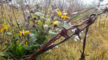
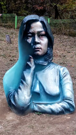 Back on the near bank, we followed the trail up to a gazebo/pagoda hybrid that overlooked the waterfall once more, before following a side trail up and over to a sculpure garden that included various works of outdoor art inspired by the war or the peace as well, as a missile and several tanks that were leftovers from the fighting. One of the most fascinating pieces was a painted sculpture that blended 2d and 3d art. The sculpture was the bust of a young woman, but only half of it was painted realistically, the other half had been painted blue. In addition, the depth was unrealisitc as well. The combination created an illusion of a different perspective of portrait from each angle as you walk around it. There was also a kitchy photo frame where we took a group shot, and a copse of giant eyeballs which was meant to show the sourse of all the tears shed for those lost. There were art pieces made from the objects of war, such as the barbed wire dandilion, and other shapes made from reforged metal. All in all, it was a surreal yet emotional tribute to the history and tragedy.
 From the park, we wended our way over to a small war memorial. Mostly we stopped here because it was necessary to file more paperwork for the Eulji Observatory. The memorial was very artistic and very sad. There were nine pillars representing the nine big battlefields in the area (Dolosan, Daeusan, Bloody Ridge, Baekseoksan Mountain, Punch Bowl, Gachilbong, Danjang Ridge, 949 Hill, and Christmas Hill), as well as statues of soldiers, displays of weapons and a whole room the floor of which was covered in shell casings from the war. Growing amid the barbed wire and destruction were small and beautiful flowers. There was a poem there ending in the stanza:
The Land of Guardians
A leaf of grass, a flower, don’t look at them as usual
And please don’t forget
Freedom today is stained with blood
Tears of sublime sacrifice underneath the smiling Peace.
When you pass by Yangu, the land of myth,
Stop at the sight of flowers red as blood,
Regard them as souls bloomed,
And please take your hats off, brooding awhile
Slowing down your busy pace.
 While reading these lines, I stood over the discarded shell casings, and under the helmets of dead soldiers, my camera filled with photos of beautiful flowers growing around the site. Although small and far less grand than the UN Memorial in Busan, the closeness of things these men had touched or died in amid the natural beauty of wildflowers and creeping red ivy brought the tragedy of war far closer to my heart than a cemetery or a statue ever could.
Euliji Observatory
(I don’t have many photos from the day, but thankfully, the South Korean board of tourism has published a few from the area that show the Northern side and interior of the Observatory so you can see them, too.)
The drive up to Eulji Observatory was interesting because for large parts of the ride, we rode with the border fence directly to our right, staring though it toward North Korea, which looked bleak and empty compared to the Southern side of the border. The day had been partly cloudy but with decent sunshine and fluffy white clouds, but as we drove up the mountain, it became gray and misty. Perhpas it was just the elevation, but it did give an aura of doom, gloom and Mordor to our encounter with the border of violent and secretive North Korea. Armed soldiers came on to the bus several times to count us. The Americans were notably less disturbed by the sight of military weapons close up and it was easy to tell which expats were from countries where such things are still uncommon. We were told that photos at the observatory were somewhat tricky, since we were allowed to photograph South Korea and the outside of the observatory, but *not* North Korea or anything inside the Observatory.
Several people tried to take photos of a memorial pillar against the fence, but even though the fence was blacked out, they were asked to delete the photos. The Korean soldiers guarding the area were very polite and respectful, but did ask to see phones if they spotted anyone pointing a phone toward the Northern side. I put my phone in my pocket and went up to the fence to peer through the cracks and get a glimpse of the forbidden North. The mountains and valleys beyond were bereft of signs of human occupation. Behind me on the South Korean side lay the famous Punch Bowl, once a bloody battlefield and now a well developed agricultural area, the land divided into neat geometric shapes for crop management and dotted with low wide buildings. In front of me, through the narrow slat where the tarp covered wire fence met the concrete base,  I could see one winding dirt road, some tires stacked and filled with dirt or sand to create a barrier, and a lone watchtower surrounded by more barbed wire fencing. Beyond these decrepit signs of occupation, the land seemed as wild and untouched as though looking back in time to before humans even arrived. Coming from South Korea, where all the land is so thoroughly occupied that wildlife is all but vanished, it was a stunning contrast.
 Inside the observatory, there is an enclosed viewing platform that overlooks the North. A brave soldier who spoke some English decided to read an English presentation to our large group. He was very nervous, but it was a great gesture that he wanted to share information with us, so we filled the small auditorium and listened politiely while staring at the mist shrouded emptiness behind him. He told us about famous battle sites around the observatory including Stalin Hill, where the South lost some land that is now part of North Korea, a radio tower used to block signals traveling into the North, and a distant waterfall called Fairy Waterfall where beautiful North Korean women used to bathe nude to entice South Korean soldiers. He also indicated that North Koreans did use the area nearby for agriculture, although to my eyes it looked completely natural and I cannot imagine that the food they harvested there would be anything more than wild gathering.
 I stepped back outside, feeling disoriented from the whole experience, looking back and forth across the narrow fence from a high vantange point where I could easily see North and South at the same time. (hint, the South is on the right, the North is on the left) Large ravens swooped around the peak, effortlessly gliding between the two countries gripped in cold war, alighting on the Northern watchtower, then returning to our parking lot to scavenge for crumbs left by tourists.
4th tunnel
 Our last stop for the DMZ day was the 4th Tunnel. This sounds fairly ominous, because it also implies there are at least 3 other tunnels, which there are. The North has tried on at least 4 occasions to literally tunnel into South Korea to get troops behind the border for a massive attack. Before heading over to the tunnel entrance, we scooted inside the nearby museum for a quick propaganda film. The film was in Korean, but had English subtitiles. They were long, small and hard to read over the video, as well as not being the most accurate gramatically, but I got the gist: North bad, South good, Threat onging. The idea that the Korean War is over is not something that really exists up near the border. To be honest, it doesn’t really exist in Korea at all, but most of the time Korean citizens can ignore their war with the North the same way Americans don’t let the 7 wars their country is involved in affect them on a daily basis. This film was a little startling however, because it didn’t even make an attempt at looking like an “unbiased documentary” and was more in a tone in keeping with propaganda material from the 1950s-60s during the cold war with Russia, or the modern Chinese government propaganda films. I’m not sure how old the film was, but it certainly felt out of time.
 After the film, we filed into a large round tunnel. The tunnel we were walking into was dug with a serious drill by the South Koreans in order to reach the less sophisticated North Korean tunnel. It was a long walk, less than 1km I’m sure, but the tunnel was dim and damp and nearly perfectly circular thanks to the diamond tipped drill the Koreans had used to make it. Hard hats were available at the front, but there were nowhere near enough to accomodate our group size, so we simply left them behind. Inside the tunnel was another no photos zone. Fortunately, the internet provides, so you can see some photos that other people (including authorized tour guides) have taken of the tunnel and equipment.
As we stood in line in the dank underground tube watching water drizzle down through a crack in the rock above, someone in the queue pointed out how much like waiting in line at Disney Land’s Pirates of the Caribbean ride it felt. I couldn’t disagree; it was underground, dark, dripping water, although the armed soldiers were real instead of animatronic pirates. In a moment I can only blame on the sheer absurity of our situation, we decided as a group that the experience would hereafter be known as DMZney Land, where the atrocities of war are wrapped up in neat little display packets for visitors to line up and experience by the busload.
 Where the modern and sleek South Korean tunnel ended, there were clear toolmarks in the rock, concentric circles left by the drill. Intersecting our tunnel was a much smaller one, no more than 2 sqare meteres, and rough hewn, carved out with picks and dynamite. A small train awaited us, one seat behind the next as the tunnel was too narrow for two abreast. The seats were low and a transparent panel protected us from the threat of falling rocks above, but the sides remained open. We climbed in, feeling even more like boarding a ride in a theme park, expecting a trek through the rugged rock. After a mere 100 meters, the train came to a stop. We could see tool marks, and holes that had been prepared for the next round of dynamite. I forgot for a moment about the photo ban, but when I snapped a few, the soldiers only politely reminded me not to and I put my phone away again.
After a few minutes, the train moved us backward along the rail to our point of embarkation. I wasn’t sure what had happened, so I asked one of our guides to find out why the trip had been so short. Once the next trainful of tourists was on its way, she was able to ask the guard there more about the tunnel and the train. It turns out the reason we stopped is because we had gone right up to the border underground. I don’t think it was actually the border of North Korea, I think it was more likely the border of the non-civillian section of the DMZ, but it was still chilling to realize how close we’d come, or rather, how close the North had come to succeeding in their infiltration plan.
Outside the tunnel is a memorial statue to a military dog named Hunt who died while helping to rid the area of landmines. The tunnel was only discovered in 1990, and although North Korea claims it was for coal mining, there is no sign of any coal in the granite through which the tunnel was dug. American and South Korean forces are maintaining a look out for possible 5th or even 6th tunnels to this day.
Hotel in Sokcho
By the time we emerged from the tunnel, the sun had set, and the mountains were wreathed in the last glimmer of twilight. We boarded our buses in the dark and headed over to our hotels for the night. The only real reason this is of any blogworthy interest is because our hotel had both indoor and outdoor spas and pools. My experience at the jimjilbang in Jeju was great, but highly segregated. Here, we got the chance to sit around in our swimsuits in mixed company with some cans of beer and feel the contrast of the warm spa water and the cold mountain night air. The whole experience started like a jimjilbang, and we had to clean off in the showers before heading outside. The pools closest to the door were cooler, and by the time we got all the way to the upper levels and warmest pools, I was shivering intensely, but it was worth it to enjoy the wonderful outdoor spa.
I try not to dwell on the sleeping arrangements for these trips, because we go in for economy. This time we ended up on the floor again, and I gather no one slept terribly well, all of us relying on our excitement of travel to keep us going one more day.
Seoraksan
Early in the morning, after a buffet breakfast, we headed out to the famous national park for some hiking and autumn leaf viewing. The weather was still rather damp, but that just made the colors of the trees and rocks around us stand out more. Seoraksan is quite famous among Koreans for it’s natural beauty, it’s giant bronze Buddha, and it’s fall foliage. Even wih the drizzly weather, the park was still packed to the gills when we arrived. I’m so used to hiking in the woods being a quiet escape from humanity, so this was a very big contrast. Even when climbing the famous Mt. Hua and Mt. Tai in China, I didn’t feel this crowded.
 The parking lot had more tour buses than Disney Land, and when we passed through the main entrance, we were greeted with a wide stone road lined with restaurants, cafes and other businesses catering to park-goers. There are several trails that can take over 12 hours, but we didn’t have that much time. After doing some research, my companions and I decided we would see the big Buddha, then walk the short (2 hr) waterfall trail, and finally take the cable car up to the highest peak for a look around.
Our very first task was to buy cable car tickets, since the tickets are sold by time and sell out early in the day. In fact, even though we;d decided to do the cable car last, nearly all the tickets before 1pm were already sold out by the time we found the ticket office. I gather that most of the year the cars run every 15 minutes, but during the weekend we were there, they had cars running every 5, holding 50 people each, and all of them were sold out by the end of the day. That’s 600 people an hour or about 4,000 people in a single day. And that’s just for the cable car. I really have no idea how many were in the park, but when I say it was full, I’m not joking.
 Our tickets in had, we followed the signs toward the temple, passing more and more restaurants, cafes and other buildings of unknown purpose. We rounded a corner and spotted the giant statue from a distance and made a bee line straight for it. The first thing that struck me was how similar it was to the Buddha at Kamakura I’d seen last year (and totally forgot to write about but follow the link for pics). Both large metal stautes had hidden entrances as well. We took our photos and wandered around the area, watching as other visitors engaged in prayer or selfies or some combination of the two. For me, visiting famous temples is more often an act of tourism even though I call call myself a Buddhist. I imagine it’s the same way that many Christians visit Notre Dame or other famous churches to appreciate the art and history rather than to attend service. I did take a moment to find my center and become mindful of my experience, and my friend made a votive candle offering as well, so we weren’t total gawkers.
The Sinheungsa Temple was burned down in 699 and rebuilt in 710, and many believe it to be the oldest standing Seon (Zen / Chan) Temple in the world. The statue (built in 1992) is 16.9m tall (not counting the nimbus around/above his head) and contains within some pieces of the Buddha’s sari recovered after cremation, and a copy of the Tripitika (the Buddhist “bible”). The Kamakura Buddha is a bit shorter at only 13.5m, but much older, having been around since 1252, and represents a different branch of Buddhism, being a statue of Amida Buddha from the Pure Land sect, while the Seoraksan Buddha or Tongil Daebul (Great Unification Buddha) is from the Seon school and represents the sincere desire for Korean reunification.
Biryong Falls Course
 Trying to keep ourselves on a decent timeline, we said our farewells to the stunning statue and set off in search of the trail-head to Biryong Falls. We soon joined a stream of Koreans dressed to the nines in their special hiking clothes. For many Koreans, espeically the older ones, outdoor activities are a serious glamour show. All the clothes are brightly colored and brand new looking. Meanwhile, my friends and I were dressed in jeans and hoodies because that’s usually how we walk in the woods at home.
 The path involved some beautiful views of the surrounding mountains. Unlike the Busan mountains which are low and covered in a softening green layer of trees, the Seoraksan mountains burst from the treeline with jagged teeth of bare rock, and this day, the whole thing was wreathed in clouds and mist making it even more haunting. We took a wide bridge over a river and ambled joyfully along the forest path, stopping to admire the trees on a regular basis. The Koreans around us took some pictures, but only at designated picturesque spots. The rest of the time they were in a hurry to get moving. So much of a hurry that we were jostled, bumped and even shoved if we were deemed to not be going fast enough. It was like being in the subway… for several km. We tried to walk on the side of the path, or even just step OFF the path when the hordes of ajuma came barrelling down on us, but it didn’t always work.
Eventually the trail thinned out and it became harder to get out of the way. The ground left soil behind and became a wet and slippery ascent of natural stones that were precarious and challenging to hike up. The Koreans all had special hiking shoes and one or two walking poles apiece for balance and had zero patience with us for hiking in only trainers and not having sticks to balance with. More than once, I was worried that one of the shovers was going to knock me down or even knock me off the edge! It was a big contrast to the DMZ park where everyone had been patient and taken turns on the river rocks. At one point I moved as far off the path as was safe to stop and take my coat off. I got bumped into by people coming from behind 4 times. More than once they looked at me as though it were my fault for not getting out of the way. Heaven forfend we should want to stop on a bridge to admire the view or take a photo. There’s nothing so nerve wracking as having ajuma shove you while you’re balanced on a thin rail of metal over a pounding white water river below.
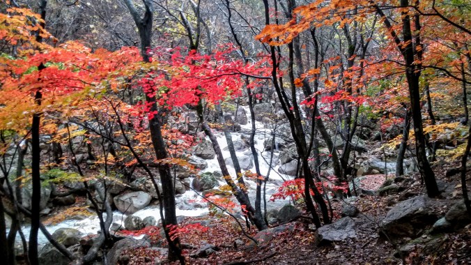
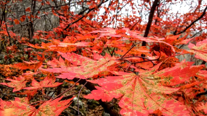
However, despite the nerve jangling crowds, the hike was absolutely stunning. There were still quite a few trees dressed in green, but that only served as a better backdrop for the fiery reds and golds that permeated the woods.  As our path ascended beside the river, we were treated to the kind of views normally reserved for high class calendars and natural beauty screen savers. My computer randomly shows me stunning nature pics every time I log in, and I swear that one of them was actually from Seoraksan. We climbed up the slippery rocks, clinging to the railing and nearby trees until we reached two more bridges crossing the lower Yukdam Falls. The maps and pamphlets all say it’s just a 40 minute hike from the main entrance to these falls, but it had taken us close to 90, proving that 40 minutes was measured by ajuma walking standards rather than beautiful day in the woods standards. I understand that Biryong Falls was only a little farther up the mountain, but in order to make our cable car time, we had to turn back early.
Cable Car & Tiny Temple
 Our last adventure for the day was to take the cable car up to Gwongeumseong. This particular peak is only accesible by cable car and can’t be hiked up to. We’d gotten our tickets as soon as we arrived at the park, so all we had to do was wait for the sign to show our boarding time and file on. These are decently large cable cars, and hold 50 passengers at a go, all standing and no personal space. My friend decided to play elbows for us and wrangled some spaces right along the rear window so we could watch the ground disappearing beneath us as we ascended into the clouds. We were able to see the main park entrance laid out below us, including the giant Buddha off to one side.
 As we rose, the clouds soon fell below us, covering the view of the ground and the sea became visible off to one side. I had known Seoraksan was near the coast, but I had not realized how close to the ocean we actually were until that moment. The cable car stand at the top had more amenities, food and restrooms and coffee shops, but we swept past them and onto the viewing platform. I had read ahead of time that one could walk all the way to the tippy top from here and see an old castle, but after my experience on the waterfall path earlier, I was reticent to follow another stream of hundreds of hikers. We walked around the viewing area and found a distant waterfall, a long streak of white amid the green and brown of the mountains, visible even at this distance it must have been enormous up close.
 While searching for more and better angles to take majestic photos of the panorama around us, we stumbled upon a small path leading downward that no one else was on. The small sign indicated there was a temple (templ-ette? I’m not honestly sure how to translate this word in English) about 70m downward. We carefully balanced on uneven, wet and slippery rocks, clinging at times to the chain along one side of the path. 70m isn’t far on flat ground, but it took us a while to cover it on the mountainside. We also stopped to admire the views often. When the path leveled out, we were greeted with a tiny hut, decorated in Buddhist style. We doffed our shoes and went inside. The warm interior was a welcome contrast to the chilly outside air. The ceiling was covered with lotus lanterns and small candles burned on the altar. The air was so still, I had to stare at the candles for a few minutes before I decided they were flame and not electric.
Our whole day had been so hectic and crowded, it was bliss to sit on the plush carpet and just enjoy the calming music playing on the sound system. While we were meditating, the monk came back inside and seemed a bit surprised to see us there. I don’t know if I want to go too far into what I experienced internally, but I definitely received the answer to a question that had been bothering me. My friend also found some answers in her meditation that helped her to find her way again after some troubling times. Buddha isn’t a god, he doesn’t answer prayers or give us things, but quiet reflection is hard to come by and can make a space for us to hear the answers we already knew. This temple, however small and remote, had a sense of peace and purpose. Even it’s name reflected this, translating in English as the “love and happiness temple”.
When I stood to offer a respectful bow to the altar, the priest caught my eye as I straightened up and smiled broadly, bowing to me and greeting me in Korean. My friend was still meditating, so we were quiet and did not speak much beyond greetings, but I could tell he was happy that we had come in with intent and respect.
Once both of us completed our meditations, we headed back up to the cable car feeling cleansed and refreshed. Some other expat tourists asked us what was down the path and I told them. Then they asked if it was “worth it” and we had a small discussion on what that meant. The temple-ette was tiny and not very architecturally or artistically stunning, but spiritually, mentally, emotionally, the peace we found there was priceless to us.
As the fall moves on, I treasure the memory of this temple most from the weekend experience. Things are not getting calmer or easier for me as an American or for everyone living in Korea dealing with the political uncertainty here. Religion and spirituality are tricky topics, and I’m not out to preach or convert, but the core Buddhist tenant of loving-kindness is something I think we can all use a little more of in our lives.
I met with some other Americans after the election and someone reminded me that one of the most important roles of the expat is “soft diplomacy”. We go out and show the face of the people, instead of the government, and when we come back, we can tell stories of the people and places we’ve seen, sharing things the news and the movies miss out on. I hope that my travels, stories and experiences can serve to help show the value in diversity, in natural preservation, and in open-mindedness. Thanks for reading, and please be sure to see all the photos from the DMZ and Seoraksan over on Facebook! ❤


")

 Interviews


 Apply like mad, but weigh your investment. There is something to the idea of applying for jobs even if you don’t meet all the requirements, but in the case of jobs abroad make sure you do meet the visa requirements (set by the government) and there can be some flexibility of the school’s requirements (set by the Dean). However, when employing the scattershot application tactic, be sure to draw the line at applying for jobs that will waste time and energy for too little potential return.
 Don’t give up. Cry, eat too much chocolate, put that

 In the weeks leading up to the event, Facebook groups circulated ads, support, rumors and questions as it became murky as to whether the festival’s organizers were in fact granted the required permits to host vendors, performers and the ever important march through the crowded streets of Haeundae. There was some fear that the vendors would be denied a permit and a rallying cry for them to show up anyway and risk arrest for the cause. (Thankfully, that didn’t seem to be necessary).
 We passed booths promoting awareness, selling pride pins, flags, t-shirts, art and books. We bought a few small things, more to support the vendors than anything else. One booth was just for birth control awareness, which is a major issue in Korea since it is still very stigmatized and difficult for women to use it regularly without facing harsh judgement from friends, family and even medical professionals.
 While the booth selection was not as big as the Seoul event, the protesters weren’t as bad as their Seoul counterparts. There were far fewer of them, and they didn’t have any giant trailers with loudspeakers or competing musical performances. Most of them simply held their signs quietly. A few shouted slogans, but the only one shouted at me was “Jesus is love” which is not bad as protest slogans go… I mean, really it’s the same reason why enlightened Christians think marriage equality is right… love is love, man.
 When the sign wavers got too close, the police gently moved them back. There was no force or violence, but the police would form a blockade and firmly move the problem folks back out of range. One man was so transported by his prayer, he knelt as close to the event as he could get, clutching his sign and praying feverishly, eyes screwed shut and knuckles white.
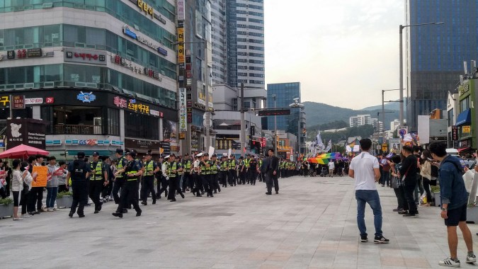 Frantically trying to IM another friend in the parade to figure out which way to go, we walked up and down the street lined with protesters holding signs about sin and Jesus and homosexuals out out out. When the marchers finally arrived, we found ourselves on the wrong side of the police line! We stood among the protesters who waved their fists and signs and chanted their message of opposition. From this vantage point we saw the giant rainbow flag at the head of the procession and we cheered as loud as we could to drown the voices of those around us and support the marchers we had been unable to join in time.
 As the parade moved closer to us, the police moved the line of protesters further and further back to prevent clashes. We pointed somewhat frantically at our own rainbow pins and flags as we asked the officers if we could cross the line and join the group inside. Finally, realizing we were not a threat, they let us through and we joined the group of hundreds (possibly thousands) dancing and singing along to the K-Pop blaring from the backs of the trucks that had lead them on the brief march around the block.
 I’m not sure what the actual parade route was, but I know it must have been short for it was scheduled to start at 4, and was more or less over by 4:30. By 4:45 everyone had dissipated and the plaza was being swiftly converted for whatever event had reserved the space for the evening hours. I also cannot report on the turn out at this time, as there has not been any English language media follow-up reporting on the numbers of attendees, counter-protesters, or police. If I get some information later, I’ll update it here.


 Skipping ahead to the first century CE, we get what is known as the Three Kingdoms Period. The three kingdoms were Goguryeo (purple) controlled huge swaths of the north including what is now North Korea and parts of China (it is also where we get the English word “Korea” from, since their word for their own country is hanguk) The south was divided between Baekje (yellow) on the west, and Silla (blue) on the east. Except, there were more than three. The Gaya confederacy wedged it’s way between Baekje and Silla for almost 500 years. And let’s not forget
  Between it’s mythic founding 42 CE and it’s surrender to Silla in 562 CE, the Gaya confederate existed in the south central area of the Korean peninsula, just barely missing Busan (where I live) but keeping it’s capital in the nearby Gimhae (where our airport lives). They did some fishing and agriculture, but were most famous for their ironwork. It was a rough confederation of 6-12 different Gayas. When they Japanese invaded Korea in 1910, they claimed that Gaya had been a Japanese military outpost from 300-710 to justify their “return”, but no scholars take this claim seriously today.
 As we entered the park, the first statue was of a giant golden egg with 5 smaller eggs around it’s base. I was taking pictures of absolutely everything, hoping to figure it out later, so I snapped a shot and kept walking with the group. My co-teacher saw me take the picture and told me that the egg was there because the founding king of Gaya was hatched from an egg that fell from the sky. She also referred to this as “history” although I’m hopeful the last part was just a linguistics flub and that no one here seriously thinks that kings really hatched from sky eggs in the good old days. I could not figure out how to ask this without sounding rude, tho, so I let it go.
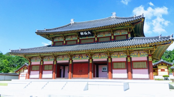 We made our way deeper into the park heading directly for the palace. It’s a replica palace. Very little archaeological evidence of Gaya has been found, although the tomb of Suro (first king of Gaya) is maintained in Gimhae as well. The palace grounds are reminiscent of Chinese palace architecture with familiar canted roofs and wide open courtyards between buildings. The colors and designs are quite unique to Korea, being less the scarlet and gold of China and more earth toned versions of dusty rose, pink, taupe yellow and pea green.


 One room had a huge map along a wall showing the queen’s “romance road of Asia”, paths from India to Korea picked out in red and blue. Another sign seemed to imply that the queen had brought Buddhism into Korea, however that is highly unlikely. I suppose she may have brought hers to Gaya (assuming that she was actually Indian) but the northern Kingdom of Goguryeo got it from their Chinese neighbors. I question her Indian origin story because the myth (written originally in the Samguk Yusa in the 13th century, it’s a kind of history/mythology mashup of the Three Kingdoms period) refers to her as being from Ayuta, a “distant kingdom across the sea”, but the name doesn’t correspond to the name of any country or city from that time period in India or any other country.
 We took our time around the palace complex, letting the kids run off some of their excitement after the long bus ride. There were plenty of historical things of interest, but no teachers tried to make the kids focus on learning, nor was there a guided tour where kids were shuffled from one room to another while someone explained things. They did separate out the grades so that no one building became too full, but on the whole, the kids were on their own to enjoy the space.
 After a while, we headed out of the palace complex and back toward the main entrance to the theater. Turtle imagery was everywhere. A large mountain with an artificial waterfall towered over the theater building. A gray stone turtle lurked in the pond below and another golden one perched precariously on an outcropping halfway up the mountain! I asked about the turtles, but my co-teacher didn’t know (don’t worry, there’s an answer later).
 The story began with two archaeologists stumbling onto a large cache of relics from the Gaya period. Their song explained with some lament how little was known of Gaya before this discovery. Then a cave in knocked our archaeologists unconscious and a hazy dream fantasy of the mythstory of King Suro began in earnest. Dancers dressed as the zodiac animals performed intricate dances on stage as some kind of high priest or shaman character sang of the strife, war and drought in the land, praying to the heavens for deliverance which arrived in the form of 6 eggs. (although all 6 eggs hatched out kings, 5 of them were elsewhere being kings of other parts of Gaya, so aren’t in this story)
 The glowing egg hatched to reveal the full grown form of Suro who is proclaimed king on the spot and is expected to wield the power to heal the land. Yay! But it’s not easy being king. The drought continues and his people begin to resent him for not living up to the promise of his celestial birth.
 Meanwhile in Ayuta (India?), the princess Heo has a dream that her destined love is in a land far away, and that she must set sail to reach him and fulfill her destiny (lots of destiny). The dancers costumes were reminiscent of saris and there were certainly hints of Indian Bollywood style music and dance moves that were obviously meant to place the princess and her handmaidens in India.
 But OH! The villain! Satal, a god of war and a gleefully over the top villain dressed in a skull mask and rough furs and accompanied by evil temptresses dressed in black and red gauzy costumes came on to sing his number about how he would defeat Suro and become the king of Gaya, keeping the kingdom forever in a state of greed, hate, and famine. His musical style was that of classic hard rock and the stage was lit by enormous flames as he and his minions sang and danced.
 The princess’s ship is caught in a deadly storm and she is washed ashore in the wreck. It seems the moon itself has saved her just in time to be found by king Suro and they sing a touching love duet in the style of popular Korean ballads. But their happiness cannot last. Satal and his minions kidnap the princess and beat Suro nearly to death in battle. He wants to give up. He didn’t expect this to be so difficult. Where are the heavenly powers he’s supposed to have, after all? But his loyal servant reminds him of the plight of his people and the love of his princess and his resolve is bolstered.
 During a rallying all cast dance number, new armor is forged for the king, turning him from a dandy to a warrior. He is told he can receive the remainder of his heavenly powers upon the mountaintop and so newly armored he ascends to greet the powers of heaven, represented on stage as a white dragon flying around Suro to strengthen him. However Suro fights, Satal holds his own and the soaring duet of hero and villain waxes lyrical about the evils of greed, selfishness and divisiveness being defeated by the power of love. In the end, it is not the armor or the power of heaven that gives Suro the strength to defeat Satal, it is the love of Heo, her voice joining the song to call back to their duet and the fact that their love was made in heaven.
 After the musical, we escorted the kids back over to the palace where they unpacked tiny picnic blankets and box lunches under the watchful eye of the staff while we enjoyed the cool, fresh mountain air. When the kids were all done eating, they were turned loose in the playground section of the park while the grownups had a lazy lunch of fried chicken next to the lake surrounded by heaps of purple pansies.
 On our way out of the park, I spotted a turtle garden with empty shells that kids could climb in and around, as well as a happy, smiling gray stone turtle overlooking the scene. The sign near the stone turtle informed us that the mountain where King Suro’s egg landed and hatched looked so much like a laying turtle that it was named Gujibong (gu meaning “turtle” in Korean). Which explained the mystery of why there were so many turtles around the park.

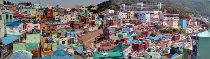
 During the war, Busan was the only city in Korea that was not taken over at some point by the invading northern army. While elsewhere all over the peninsula, whole towns were being leveled to the ground, Busan was becoming a haven for refugees as well as US and other foreign aid troops. The population crisis caused the unique housing style of Busan, which involves building houses and apartments right up the side of the mountains that weave in and out of the city.
 The houses are painted a cheerful array of bright colors that make for a stunning view from the ridge above. However, once you descend into the neighborhood, there is no end of quaint surprises in the form of beautiful murals, surprising statues, and wandering flower planters. The neighborhood is not only adorable, it’s become a hot spot for bohemian culture, local artists, musicians and other experimental creations.


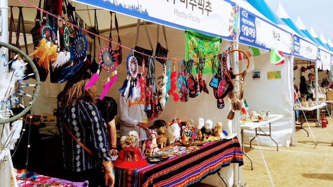
 I went to this festival last year when it was held at the citizen’s park, which a beautiful grassy park with trees, a beach, and a big fountain. I had a great time visiting all the booths from other countries and sampling goodies they brought. There was a large space in the middle of all the tents where we could flop down in the grass when we needed a rest and I ran into lots of fun people (most of whom have since returned to their own countries) and sat on the lawn drinking the German beer and Spanish sangria until the sun went down.


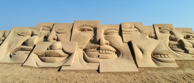

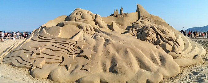
 This year… I’m not really sure what the theme was. Each mound only had art on one side, yet despite the fact that there was a temporary walkway between the two rows of mounds (because walking in sand is hard), the art all faced the shorefront buildings, leaving only half facing the walkway and the other half showing their backs. The backs of the mounds remained smooth but for a single word that was presumably the inspiration for the art on the front.


 of the festivals I go to are Korean, I’m still in the minority almost wherever I go. Almost. I don’t know what Haeundae looks like on a regular day because it’s so far from me that I usually go to Gwangan when I need a beach fix. On this day, it was like that scene from Lilo and Stitch where Lilo goes down to the beach to stare at pale tourists. Only most of them were fairly fit being recent college grads or military folks on leave. But so much white people!
 us the wait ahead of time, and we agreed. That should be enough, but part of me was still, “how did they not staff more people on a festival day, the restaurant should be doing something to make up for this inconvenience”… Woah, ‘Murica brain. You didn’t have to come here. They did everything reasonable to make sure you knew what was going on. Check your entitlement! PS. There’s no tipping here, so when waitstaff are nice to you it’s just their job and not because they’re livelihood depends on the whims of customer satisfaction.
 After dinner, we headed over to The Back Room, a secret speakeasy style bar that I visited last year and loved. I had an old favorite (real whiskey sour), and tried a brand new concoction tried an Aviation, which is gin based cocktail with creme de violet, lemon and cherry. Fancy and delicious. We stayed out way too late drinking and chatting, which only served to remind me that every event can be made special with friends.
 We set off from Busan (blue dot) in the morning to drive all the way across the southern end of the Korean peninsula to Jindo (red dot). Although Korea is small compared to, say, the US, it was still almost 5 hours of driving with the occasional pit stop. (By the way, in case you’re curious, you can see Daegu on this map as well). Fortunately, I went with a tour group (my stand by
  The Jindo festival had at least one feature I’ve never seen before: a traditional Korean wrestling ring. A pile of sand was placed in a large circle where two contestants could wrestle in the traditional style.
  Even more bizarrely, after the color throwing was over, the festival organizers gave each participant a “toga” to wear. The togas were long white robes with red sashes that could have evoked a Roman senate or Jesus. Considering we were about to “part the seas” it was hard not to see it with Judeo-Christian overtones, but the rather drunk person I asked about it just said “toga party!” The entire thing seemed like the festival organizers were trying to find a way to appeal to the expat crowd. I’m glad they had fun, but I would have preferred some more traditional activities, like someone to teach us about collecting clams and seaweed the way the locals were doing as the tide went out. It’s hard to go do local culture festivals when the locals are busy trying to white-wash everything for cash.
 Finally, the real “reason for the season” was upon us and we muddled our way down the road to the rainbow steps beneath the watchful eye of the grandmother and the tiger. We paused at a bench to don our thigh high rubber boots and got some advice from the locals on how to attach the rubber garters through belt loops to hold up the boots, or failing that, to wrap them tight around our thighs and snap them in place. Thus clad in bright orange and yellow wellies, we made our way down the steps and into the shallow tide pools to wait for the tide to recede.
 If you look at the area on Google Maps you will simply see the beach and the islands, but on Korea’s own Naver Maps, there is a thin line connecting the rainbow steps to the island of Modo. Although this path is only usable twice a year (at most), the Korean map makers consider it important enough to draw in.
 The history of tidal prediction starts with Kepler (total nobody) in 1609 to theorize that the moon’s gravity caused the ocean tides. He was followed by other such no-ones as Galileo and Newton. It was in 1776 that the first big complex equations came from a man called Laplace. Harmonic analysis was added in the 1860s and polished off by 1921 in the form that Navies all over the world still use today. Although the math hasn’t changed in almost a hundred years, computers make the math easier and the information more widespread so now instead of just ships in harbor– surfers, beachcombers, and clam hunters can
  On a more mystical note, the local legend of the tigers explains why there’s a statue of a grandmother and a tiger overlooking the sea. Long long ago, the villagers who lived on Jindo were plagued by man-eating tigers. The whole village packed up and sailed over to the neighboring island of Modo to escape the threat, but one woman was left behind. The woman was Grandmother Bbyong, and she prayed to the Dragon King, the god of the sea, to help her. Finally the Dragon King came to her in a dream and told her he would build a rainbow brigde across the sea for her. The next day when Bbyong went down to the sea, the waters parted to let her cross and her family came out from Modo to meet her. This also explains the rainbow stairs that lead down to the landbridge, but not why her family couldn’t have just sailed back for her in the first place.
 While math can now easily tell us the time of the lowest tides, it does not yet advance to tell us what the actual lowest level of the water will be. Not that it couldn’t, but there are more variables involved, so it’s not a thing now. While we can say with certainty, the lowest tide of the year on this beach will occur at 18:38 on April 29 (or whatever), we can’t say for sure if that will expose the land bridge or simply be lower than every other tide around it.
 We tromped along the path, watching parasailers overhead and rainbow colored lanterns being released in to the air from the beach behind us. It was clear the path was quite narrow because going too far from the group to one side or the other to get a picture resulted in a severe deepening of water level. At the time, my friends and I theorized it might be man-made, or at least man-maintained, however, I have since then found that the build up of rock and sand in this twisty line is a natural result of the currents around the islands.
 Before long the golden light of the sunset combined with the swish-swishing of hundreds of feet through water to create a trance-like state. I could not judge how far the island was, nor tell which way the path twisted. The rocks below us rose and fell, bringing the waves treacherously close to the top of my boots and then back down to barely splash over my toes. The whole path is nearly 3km long. I suspect a determined person could make it out to the island and back in the hour or so the path is clear to walk, but I wasn’t racing, and soon we were greeted by the sounds of Korean drums and the distant flags waving as the procession from Modo came out to greet us.
 The walk outward had been slow, trepedatious, as though we were nervous the land could drop away at any moment, but the trip back was much more celebratory as well as much more damp. The parade of drum bangers, cymbal crashers, gong ringers and flag bearers danced merrily in their traditional garb, urging us all back to the larger island of Jindo. Our pace quickened and our legs swung to the rhythm causing much larger splashes. Waves came in from both sides of the path making us nervous, but excited. The water finally breached the top of my boots and sent an icy chill down my shins, but I found I did not mind.
 Before heading to the fields, we walked up a long road past the area of the light festival where a few wire frames from reindeer and dragons could still be seen. The road up the hill was painted with fun perspective illustrations of a stream, complete with little camera icons to show the best places to stand to see the visual effect. Optical illusions are fun.
 At the top of the hill, far beyond the little pagoda that had marked the highest point of the lights, we finally came upon the green tea museum where we were treated to a special showing of the Korean green tea ceremony (complete with English translation by our awesome guide). The ceremony involves a process of several containers: a water pot, a cooling bowl, a tea pot, and the drinking cup. The hot water pot is filled with boiling water, which is then poured into the bowl, and from the bowl into the tea pot and finally into the cups. The instruments are warmed up in this way. Then more boiling water is poured into the cooling bowl. Tea leaves are scooped into the warm but empty tea pot and the ideal temperature water is poured from the bowl over the leaves. While the tea steeps, each cup is emptied of it’s hot water into another bowl on the floor and wiped dry on the outside. The tea is then poured into the pre-warmed cups by pouring only a half a portion into each and the other half in reverse order on the way back. The tea is then served, 4 cups to the guest and one to the host.
 The hostess tried to tell us a bit about green tea, red tea and black tea but her translated explainations seemed off to me, since she said it had to do with the age of the leaf when it was picked from the plant. I don’t know if this was her or the translation, but the real story follows: In any country with Chinese roots in it’s culture and language, the three colors of tea are a bit different in meaning that in the West. Red tea is not Rooibos, in fact all three come from the same plant. And it’s not the age of the leaf at picking that determines the difference, but rather the post picking, pre-drying process. (although especially young and tender tea leaves are sometimes referred to as “monkey picked” and do make a delightful tea).
 After we conducted our own tea ceremonies, I drifted lazily back down the hill, examining the spring flowers and the grounds that had been lit up beautifully last December. When I finally got back to the tea fields, I took off on the same route I’d walked before and was happily greeted by many blooming apple trees and a small army of busy bees who were so focused on the brief blossoms that they paid no mind to all the humans fussing around. In fact, I think it was the only time I’ve seen Koreans in the presence of a bee not totally freaking out. I guess the selfie with the tree is worth it.
 In addition to the blooming fruit trees, there were cascades of purple flowers covering the rocks wherever tea was not growing. It made the whole place feel like a still frame of a rushing river in shades of pink, purple and green. Besides the tourists, there were also tea pickers at work. Each ajuma looking lady had her sun guards on, gloves and a mesh basket to place the leaves. They were not picking the bushes bare, but selecting only some growth. It seemed to me to be the newer, brighter green leaves that they were after, but I couldn’t tell for sure. In the age of automation it was strange to see people picking by hand. I know that it’s still the way for many crops in the world, but sometimes it gets driven home that there’s a human on the other end of my tea or strawberries or carrots, and then I’m carried off by sociological musings on how we came to value people who sit at desks manipulating imaginary money so much more than people who make our food.


 The festivities were set to start around 6pm, so we left in the afternoon and had a lazy, but comfortable ride into Daegu where we had to relearn bus navigation. One wrong bus and two right ones later, we got off in the general vicinity of


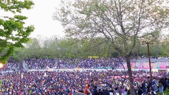
 For those who don’t know, these words used to be terms of respect for middle aged women and men, but have come to be less flattering terms used to describe a particularly rude class/age group of Koreans. Ajuma (women) tend to shove… a lot, and cut in line. Ajoshi (men) will join in on the shoving if their wives are around, but are perceived as perverts who peer into ladies bathrooms otherwise. I know that at least some of the younger Koreans use the words this way, and definitely all the expats I’ve met do. There is a culture of respect for age, so actually old frail people are often given seats and ushered to the front for views (and are usually super sweet about it, every one I’ve given a seat to has said thank you and offered to hold my bag in her lap), but these ajuma are just bitter middle agers who don’t want to stand in line like everyone else. Think of them like the entitled soccer moms of Korea. And yeah, they pretty much all look like that picture, too.
 Lanterns Aloft
 At long last, the moment we had waited for, the lanterns were released in earnest. They did not rise swiftly like balloons, but in a slow and drifting manner as the tiny flames inside each one warmed the air contained by the colorful paper dome. 1,000 globes of light ascended into the blue and black night sky, and I knew no matter how hard I tried, my camera could never capture that moment. It was what we were all here for. People from many cities and even many countries, gathered in the soft night air to witness the magic of fire in the night, lanterns becoming stars, and wishes rising to the heavens.
 Shortly after the main release was over, people around us began filtering back out of the park. They had seen what they’d come for and were eager to move on to the next attraction or to beat the traffic. This meant that we suddenly found ourselves at the fence with an unobstructed view of the field below, and enough elbow room to turn around and attempt selfies (which were less impressive due to the low light).
 Finally the last twinkling lights above became no bigger than pinpricks of stars and we joined the crowd shuffling out of the park. We had 3 hours left before our return train and sat down for a moment to check the internet for a restaurant serving anything Daegu local. While we were seated, a family carrying armloads of paper lotus lanterns came by, and the young boy gave us each one, nervously testing out his English with as few words as possible.
 With our gifts in tow, we set off toward our restaurant of choice, but quickly became sidetracked by the parade. The floats we’d seen before were now all lit up, but the parade itself was stopped again. We dodged in and out, taking more pictures and pausing to watch a monk’s drum performance. Back in front of E-World once more, we spotted a street vendor selling flying lanterns as fast as he could light them up, and we were able to get a closer look at the lights that had filled the sky less than an hour before.


 Moments later, I had a humongous bowl of seafood and spicy broth in front of me. Mussels, clams, shrimp, crab and octopus crowded the bowl and heaped up atop a generous portion of noodles. (octopus is not something I order knowingly, but I didn’t want to waste it’s life once it was on the table) The broth was rich and spicy, causing me to reach for the ice water more than once and leaving my lips pleasantly tingly by the end of the meal. I think 2 hungry people would have had trouble eating the whole thing, and my day companion was not a seafood fan, so it was all me.
 The weather was once more gray and drizzly, hot and humid, but with some sleep, breakfast and coffee behind us, we were enthusiastic to hit the road. I had done a bit of research on the crater that morning because of how the walk around the waterfalls turned out. I found some bloggers who claimed it was a 20 min walk if you just went straight up and about 40 minutes if you were a slow hiker. (it still took me about 45 that day). I felt better prepared for the hike ahead, but then we arrived late due to heavy traffic.


 According to the legend told at the temple, the first inhabitants of Jeju Island were three demi-gods who came to earth in a great flash of light and energy, and emerged from three holes in the ground. The temple is built on the site of these three holes, and no matter how much it rains, the holes never fill up with water. The demi-gods were named Go (
 After watching an informative film about the history and mythology of the shrine and the island, we wandered through the paths in the quiet woods. There are almost 1000 trees in Samseolhyeong. The other buildings included the museum where dioramas of the myth were displayed along with some of the original writings and ceremonial clothing from the earliest rituals performed starting in 1562. Additional alters, shrines, dormitories and halls were added over the years, but most were destroyed during Japanese occupation. Although the site of teh three holes is the same, the modern temple complex was rebuilt here in 1970. The walk through the trees was a refreshing break from the hot and humid weather. We admired many bangsatap (small stone towers built for luck) and more than a few dol hareubang (the stone grandfather statues that are the iconic image of Jeju).


 There were 3 special rooms along one wall of the second floor: the red clay room, the amythest room, and the gardenia room. The rooms had little doorways and were quiet and dark inside. Places where people sat on mats or lay with their heads on wooden blocks to relax or nap while enjoying the atmosphere. The red clay room was warm, but not quite sauna warm. The walls were red clay and it resembled the inside of a clay oven. I don’t think I could have stayed for long in the heat anyway, but we were driven out by one man’s snores before that. The gardenia room was a truly sauna level of hot. There was a stong floral (presumably gardenia) smell in the air, but the heat was too oppressive. My bare feet singed on the floor as I hopped to a reed mat for protection. There were many women sitting on the mats but the air was too hard for me to breath for long and I hopped back out without even sitting down.
 This park in the Nampo neighborhood is up on a bit of a mountain, but there’s no need to climb up exhausting stairs because there’s an outdoor escalator installed to let you ride up in comfort! When we got to the top, we were already blown away by the great views of the city below and we hadn’t even gotten to the highest points yet. As we passed by the stage area, it was clear that a performance was about to get underway. There were plenty of people dressed in the standard white garb trimmed with bright colors and fun hats and the parents hadn’t gotten to see any traditional dances, so we pulled up a seat. I have since found out that cultural performances happen here every Saturday at 3pm between March and November.
  The MC for the day was excited to see so many foreigners (not just us) in the audience and brought out a poor young Korean lady who was nervous and not particularly fluent to try and translate for us. Representatives from each visiting country in the audience were invited to come up on the stage and play a traditional Korean game of trying to toss a stick through one of 5 rings attached to a jar. My friend’s mom went up and they let her stand extra close because she was over 60 and she brought us honor by scoring the center ring! We didn’t sit for the whole performance, but it was a kind of musical story. From what I could follow, some performers arrived at a lord’s house and were invited in to party, but there were some rascals around who may have been trying to steal away or marry off the lord’s daughter? The language barrier was a bit of an obstacle to the plot, but it was fun to watch and clap along with.
 We snuck out during a lull and headed to the main attraction of the Park, Busan Tower. The tower stands 118m high, but it’s also on a mountain so, it seems to be rather higher than that when you look down. For 5,000won you can get a ticket to ride up to the top of the tower where you can enjoy a stunning 360 degree view of Busan. There are helpful decals on the windows that identify major landmarks and there;s a little cafe where you can enjoy a snack with your view.

 Sky Tree (left) where the small fountain lights are coordinated with the tower lights high above. These shows are fun, awesome, wonderful, and sparkly, so when my friend told me he wanted to take his parents down to Busan’s own choreographed fountain show, I was all in favor.
 There are some permanent concrete bleacher type seats along one side, but the rest of the area around the fountain had been filled up with plastic chairs to accommodate the higher number of spectators on the warm weekend nights. We arrived early and laid claim to seats in the front row, hoping that we wouldn’t have to worry about the crowd standing in front of us when the show started. Refreshingly, the Korean audience stayed in their seats during the show and we had a first class view. In both China and Dubai, the spectators jostled for the best standing spots and to get my video, I had to start standing in my spot almost 30 minutes before the show started to get an unobstructed view.
  This is 2,519 sq m fountain is listed as the largest fountain in the world by Guinness. I suppose that the show at Dubai is not considered a single fountain and is therefore only the largest fountain
  I’m not a food blogger, but sometimes food is just too good not to write about. I’ve done some basic coverage of these things elsewhere, but it doesn’t get old. Dala 100% Chocolate is this tiny hole in the wall chocolate cafe in my neighborhood in Seomyeon. The first time I went there, I had to try their signature dish, the dinosaur egg. This was an amazing concoction of shaved milk ice topped with crushed chocolate cookies and chocolate shavings with a giant egg made of cookies and cream candy. When smashed with the provided hammer, the egg reveals a scoop of truly decadent chocolate ice cream and a tiny chocolate dinosaur. If that’s not enough chocolate, you can pour chocolate sauce over it too. It takes at least two people to eat this dessert. Since that time, we’ve also tried the chocolate pizza (nutella spread, banana slices and toasted marshmallows for toppings, scoop of vanilla ice cream and chocolate sauce again), and for the two separate parental visits this summer, I also managed to try the fruit fondue (kiwi, grape, orange, grapefruit and banana… turns out grapefruit in chocolate is awesome), the “special brownie” (molten chocolate inside!), and the chocolate churros (churros you dip in chocolate). Let us not forget the milkshakes, which come in a variety of chocolate compliment flavors and can be made white, milk or dark. I don’t just love this place for it’s chocolate, but because it’s good chocolate. It’s not too sweet and they do a good balance of flavors in each dish so you don’t get tired (as if that were possible) of a single chocolate flavor. I think we’re about halfway through the menu now, and if the weather keeps cooling off, I’ll get to try their hot drinks soon!
 The melon special was not just using frozen milk, but frozen yogurt… and not the kind you’re thinking. Imagine you mix some yogurt with milk or water until it’s all liquidy, then freeze it solid, then shave it off into teeny tiny snowflakes. Ok. Now, take a honeydew melon (the green ones) and cut it in half. Hollow it out and freeze the shell. That frozen melon rind is now our bowl, filled with the snowflake texture frozen yogurt and topped with some cubes of what I can only describe as cheesecake filling.
  Now, over the whole thing, put the melon you removed from the rind, the hemisphere of melon, all of it. The dish was served with a big plastic knife so we could cut up the melon for ourselves. It was the perfect combination of sweet, tart and creamy to refresh us in the summer heat.
 When we arrived, a very nice older Korean lady offered to explain a little bit about the main gate to us in English and we got to hear a little history of the naming of the temple and the unique four pillar style that makes this era of architecture distinctive. As we ascended the stairs and passed through several gates decorated with bright lanterns and beautiful paintings we moved through a hall of fearsome statues and finally emerged into the main courtyard. The temple was originally built about 1,300 years ago, but was destroyed during a Japanese invasion in 1592 and later rebuilt in 1713, but a few stone remnants and one stone pagoda left from the original still stand in the wide open square. The temple is dedicated to the practice of Seon Buddhism, which is the Korean descendant of Chan Buddhism the same way Zen in Japan is.


 Also called the Jinju Namgang Yudeong Festival, it is held in honor of the fallen during the seiges by Japanese soldiers in the Imjin War in 1592-3 (the same time frame the orginal Beomeosa Temple was destroyed). During the war, lanterns were used as military signals, a means of communicating with reserve forces, and as a way to keep in touch with family members outside of Jinjuseong Fortress. Even after the war, people continued the tradition of floating lanterns down the river to pay tribute to the brave souls that had been lost during battle. Today, the festival is far more than a few lanterns on the river and instead is a whole palisade of life size and larger than life lanterns floating on the river and filling the riverside park where the fortress once stood.
 When we entered the display area, we were given arm stamps so we could come and go as many times as we liked, then we began our stroll down the riverside. The water was covered in giant lanterns in shapes of mythical animals and heroes as well as famous landmarks like Stonehenge, the leaning tower of Pisa, and the Statue of Liberty. There were floating restaurants, boat rides, and yet more tents offering delicious snacks.There were giant tunnels of red lanterns where couples walked hand in hand in the twilight.
 Two floating bridges at either end of the display allowed visitors to pass from side to side without returning to the street level. The day had been rainy, but as the rain dried up, the sunset lit the clouds in shades of brilliant gold and scarlet.We crossed the river and ascended into the wooded area to be greeted with the most amazing forest of light. Unlike the


